Service Navigation
Search
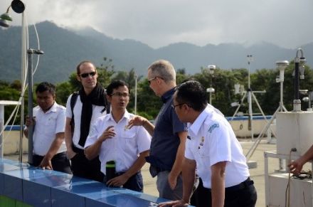
All activities in the framework of GAW and GCOS Switzerland (GAW-CH and GCOS-CH), which are currently supported by MeteoSwiss as well as completed projects and information on the recurring Call for Proposals can be found below.
Call for Proposals
Within the framework of GAW-CH and GCOS-CH, MeteoSwiss provides targeted support to projects of national partner institutions that contribute to the implementation of the GAW Scientific Implementation Plan and/or the GCOS Implementation Plan and the GCOS Switzerland Strategy 2017-2026. For that purpose, MeteoSwiss regularly issues calls for proposals. Detailed information on the open call for proposals is provided below.
In case of any questions: please contact the Swiss GAW/GCOS Office gaw-gcos@meteoswiss.ch.
What is the thematic focus of the call for proposals?
The thematic focus of the proposals is based on the GAW Scientific Implementation Plan and/or the GCOS Implementation Plan and the GCOS Switzerland Strategy 2017-2026. Depending on the strategic objective being pursued, a thematic focus of a call for proposals may address 1) both programmes or 2) only GAW or 3) only GCOS. The thematic focus is communicated when a call for proposals is open.
How can I apply?
Please fill-in the application form (Word template) and submit it including all annexes in a single pdf file using the link above.
Who is eligible?
The call for proposals is open to all individuals and consortia with a principal investigator affiliated to a Swiss institution in Switzerland.
How is the proposal evaluated?
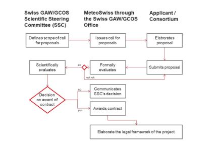
The Swiss GAW/GCOS Office conducts the formal evaluation of the proposals. If all formal criteria are met, the Swiss GAW/GCOS Scientific Steering Committee (SSC) evaluates the content of the proposals according to predefined evaluation criteria.
What is the maximum duration of a project?
The indicative duration of projects addressing the objectives described in Sect. 4.1 of the Call for Proposals Document is 2-4 years.
How will the SSC monitor the progress of the project?
The partner institution is required to provide yearly update reports to the attention of the SSC. In addition, it has to submit a final report to the attention of the SSC and a final report to be published on the GAW and GCOS-CH Website at the end of the project.
Monitoring
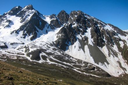
Aerosol monitoring at the Jungfraujoch research station
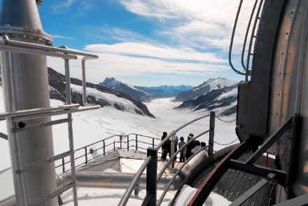
Aerosol monitoring is very important as it serves as a basis for studies investigating their impacts on climate and weather. The goal is to identify trends associated with changes in anthropogenic emissions, to improve process understanding, and to quantify impacts on the radiative balance of the Earth through aerosol-radiation and aerosol-cloud interactions. Observations performed by the Paul Scherrer Institute (PSI) are embedded in the Global Atmosphere Watch (GAW) programme on global scale and the Aerosol, Clouds, and Trace Gases Research Infrastructure (ACTRIS) on European scale. Financial support is provided by MeteoSwiss in the framework of GAW-CH and by the State Secretariat for Education, Research and Innovation (ACTRIS).
|
Period |
Partner Organisation |
Annual Volume |
Programme |
|---|---|---|---|
|
Since 2007 |
Paul Scherrer Institute |
CHF 117’500 |
GAW-CH |
Monitoring of the composition and circulation of the Earth’s atmosphere
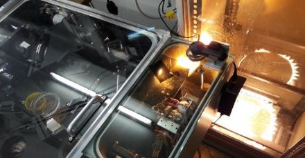
The Infrared Group of Atmospheric and Solar Physics (GIRPAS, University of Liège, Belgium) monitors the composition and circulation of the Earth’s atmosphere using infrared remote-sensing techniques. Over the last 40 years, the GIRPAS team has recorded at the Jungfraujoch station more than 60000 high-resolution infrared solar spectra, gathering a unique observational database, worldwide, in terms of measurement density, quality and time coverage. Careful analysis of these observations allows us to determine the abundance of more than 30 key constituents of the Earth’s atmosphere, involved in stratospheric ozone depletion, contributing to the greenhouse effect and global warming, or atmospheric pollutants leading to air quality degradation. Financial support is provided by MeteoSwiss in the framework of GAW-CH.
|
Period |
Partner Organisation |
Annual Volume (Current Financial Period) |
Programme |
|---|---|---|---|
|
Since 2007 |
University of Liège |
EUR 36’000 |
GAW-CH |
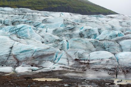
Glacier monitoring
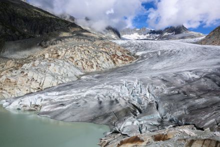
Glacier monitoring is very important for Switzerland as it serves as the basis for studies on the effects of climate change, the water balance and protection against natural hazards. The Glacier Monitoring in Switzerland (GLAMOS) network pursues the goal of long-term and regional monitoring of Switzerland's glaciers. GLAMOS receives financial support from the Federal Office for the Environment, the Federal Office of Meteorology and Climatology (MeteoSwiss) in the framework of GCOS-CH, and the Swiss Academy of Sciences and is operated by ETH Zurich, the University of Fribourg and the University of Zurich.
|
Period |
Partner Organisation |
Annual Volume (Current Financial Period) |
Programme |
|---|---|---|---|
|
Since 2016 |
ETH Zurich |
CHF 70’000 |
GCOS-CH |
Permafrost monitoring
The systematic documentation and monitoring of mountain permafrost is increasingly important as an indicator of climate change and a natural-hazard trigger. The aim of the Swiss Permafrost Monitoring Network (PERMOS) is to systematically monitor mountain permafrost in Switzerland. PERMOS receives financial support from the Federal Office for the Environment, MeteoSwiss in the framework of GCOS-CH, and the Swiss Academy of Sciences. It is operated by the PERMOS partner organisations, the universities of Fribourg, Zurich and Lausanne, ETH Zurich, the University of Applied Sciences and Arts of Southern Switzerland (SUPSI) and the WSL Institute for Snow and Avalanche Research (SLF).
|
Period |
Partner Organisation |
Annual Volume (Current Financial Period) |
Programme |
|---|---|---|---|
|
Since 2011 |
University of Fribourg |
CHF 110’000 |
GCOS-CH |
Monitoring of snow water equivalent
As well as playing a crucial role as a climate factor, snow cover is a key economic parameter for tourism, water management, hydropower, agriculture and transport. Snow water equivalent (SWE) refers to the amount of water (in millimetres) contained in a snowpack, which also corresponds to the weight of the snowpack (in kg/m²).
SWE measurements in the Wägital
The SWE time series in the Wägital valley is the world's longest-standing for any catchment area, dating back to 1943. Furthermore, totaliser measurements have been taken in this area since 1925/1926. With a view to ensuring that these time series continue to be collected, MeteoSwiss has been supporting the gathering of these data since 2010 in the framework of GCOS-CH. The monitoring network, originally managed by ETH Zurich, has been operated by the company Meteodat GmbH since 1998.
|
Period |
Partner Organisation |
Annual Volume (Current Financial Period) |
Programme |
|---|---|---|---|
|
Since 2010 |
Meteodat GmbH |
CHF 20’450 |
GCOS-CH |
Snow water equivalent measurements in the Swiss Alps
The snow stations in the Swiss Alps provide a data source unique in its quality, length and coverage regarding the spatio-temporal variability of the snowpack in the Alpine region. The WSL Institute for Snow and Avalanche Research (SLF) is maintaining long-term snow water equivalent (SWE) time series, which among others are used for snow load codes and hydrological forecasting. As there was some doubt surrounding the future of these measurements, MeteoSwiss decided to provide financial support in the framework of GCOS-CH for 11 of these stations.
|
Period |
Partner Organisation |
Annual Volume (Current Financial Period) |
Programme |
|---|---|---|---|
|
Since 2016 |
WSL SLF |
CHF 70’560 |
GCOS-CH |
Central Facilities
Central Calibration Laboratory METAS
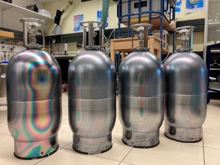
Monitoring halogenated volatile organic compounds (VOCs) in the atmosphere is important because of their impact on our climate and environment. The Federal Institute of Metrology METAS in Berne, hosts the WMO-GAW Central Calibration Laboratory (CCL) for ten halogenated compounds since 2023. To fulfil this long-term role, reference gas mixtures for halogenated compounds were produced and validated. METAS supports the measuring stations with any issues relating to dissemination of the reference values, instrument calibration and uncertainty estimation. CCL METAS is co-funded by METAS and MeteoSwiss in the framework of GAW-CH.
|
Period |
Partner Organisation |
Annual Volume (Current Financial Period) |
Programme |
|---|---|---|---|
|
Since 2023 |
Federal Institute of Metrology |
CHF 30’000 |
GAW-CH |
World Calibration Centre WCC-Empa (Swiss Federal Laboratories for Material Science and Technology)
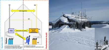
Globally harmonised data for greenhouse and reactive gases are essential for understanding the Earth's atmosphere. Since 1996, the World Calibration Centre for Surface Ozone, Carbon Monoxide, Methane and Carbon Dioxide (WCC-Empa) has contributed to the Global Atmosphere Watch (GAW) programme. Main tasks of WCC-Empa are to conduct system and performance audits at GAW stations to ensure traceability to internationally recognised standards within the network, and to provide general technical and scientific support. These regular independent assessments lead to improved data quality and data availability. WCC-Empa is co-funded by Empa and MeteoSwiss in the framework of GAW-CH.
|
Period |
Partner Organisation |
Annual Volume (Current Financial Period) |
Programme |
|---|---|---|---|
|
Since 1996 |
Swiss Federal Laboratories for Material Science and Technology |
CHF 292’700 |
GAW-CH |
WMO/GAW Quality Assurance/Science Activity Centre Switzerland (QA/SAC-CH) Empa
QA/SAC-CH is a Central Facility of WMO's Global Atmosphere Watch (GAW) programme. It is committed to secure and improve the availability and quality of atmospheric composition data measured at GAW stations worldwide. The centre's activities include (i) capacity building and station support in setup, operation and maintenance of long-term observations, (ii) research activities, such as the evaluation of new measurement techniques and scientific data analysis, (iii) contribution to GAW committees (advisory groups and expert teams) and GAW outreach material, and (iv) cooperation and networking with other programmes and projects to maximize synergies and to ensure consistency across all activities. The QA/SAC-CH Central Facility is co-funded by Empa and MeteoSwiss in the framework of GAW-CH.
|
Period |
Partner Organisation |
Annual Volume (Current Financial Period) |
Programme |
|---|---|---|---|
|
Since 2000 |
Swiss Federal Laboratories for Material Science and Technology |
CHF 153’700 |
GAW-CH |
Euro-Climhist
The data that historical documents provide about past weather and climate observations are a key resource for climate research. In the Euro-Climhist database, daily weather recordings (observations and instrumental measurements), news on natural disasters and extreme weather events and phenological data from the Middle Ages to the present day are logged, stored, analysed and made available to researchers. In a bid to ensure the long-term operation, development and expansion of Euro-Climhist at the University of Bern's Institute of History, MeteoSwiss has been providing support for this database since 2010 in the framework of GCOS-CH.
|
Period |
Partner Organisation |
Annual Volume (Current Financial Period) |
Programme |
|---|---|---|---|
|
Since 2010 |
University of Bern |
CHF 77’000 |
GCOS-CH |
World Glacier Monitoring Service (WGMS)
Global glacier monitoring is of crucial importance for climate observation. Glaciers are key climate indicators and play a central role in the regional water balance and changes in global sea levels. As an international data centre, the World Glacier Monitoring Service (WGMS), based at the University of Zurich's Department of Geography, collects standardised observations on glacier fluctuations and inventories and makes them available to researchers. MeteoSwiss has been providing financial support for the operation of the WGMS since 2010, in the framework of GCOS-CH.
|
Period |
Partner Organisation |
Annual Volume (Current Financial Period) |
Programme |
|---|---|---|---|
|
Since 2010 |
University of Zurich |
CHF 361’375 |
GCOS-CH |
Global Energy Balance Archive (GEBA)
The Global Energy Balance Archive (GEBA) is a database providing a central repository of information from around the world about energy fluxes measured at the Earth's surface. GEBA data are used in many studies, for example to quantify the global energy balance, validate climate models and satellite datasets and analyse changes in energy fluxes in the context of global climate change. They are also used in the solar power, agriculture and water management sectors. The operation of GEBA at ETH Zurich has been supported since 2019 by MeteoSwiss in the framework of GCOS-CH.
|
Period |
Partner Organisation |
Annual Volume (Current Financial Period) |
Programme |
|---|---|---|---|
|
Since 2009 |
ETH Zurich |
CHF 62’000 |
GCOS-CH |
Information regarding Projects
Projects following regular Call for Proposals have to contribute to the implementation of the GCOS Implementation Plan and the GCOS Switzerland Strategy 2017-2026 and/or the GAW Scientific Implementation.
Current Projects
Establishing the uncertainty budget of the Arosa/Davos total column ozone timeseries to support its application for trend analyses and model validation.
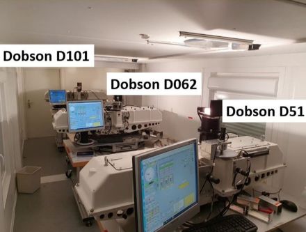
Monitoring total column ozone is critical to understanding the dynamics of the Earth's ozone layer and protecting humans and the biosphere from the sun's ultraviolet radiation. Scientists use total column ozone data to study atmospheric changes and assess the impact of human activities on the destruction or recovery of the ozone layer. This wide interest accounts for the current priority 3.1 of the GCOS-CH Strategy (2017-2026) requirements. The project focuses on the almost century-old Swiss ozone monitoring system of MeteoSwiss and the Swiss ozone climate modelling group at PMOD/WRC. The first part of the project aims to determine the individual uncertainty contributions of the Dobson instruments and to quantify the overall uncertainty of the ozone measurements. The second part will focus on the application of the uncertainty analysis, in particular the validation of the ozone model outputs and the generation of a data set combining the Dobson and Brewer measurements. These applications are addressing Pillar 3 of the GCOS-CH strategy (2017-2026).
| Period | Partner Organisation | Total volume | Programme |
|---|---|---|---|
| 2024-2028 | Physikalisch Meteorologisches Observatorium Davos and World Radiation Center (PMOD/WRC) | CHF 133’897 | GCOS-CH |
MAGIC-CH: Machine-learning based Advancement and usability assessment of GNSS Interferometric Reflectometry for Climatological studies in Switzerland
Snow, soil moisture and atmospheric water vapor are all key parameters of the global climate system and the hydrological cycle. GNSS-Interferometric Reflectometry (GNSS-IR) is an innovative technique, which allows sensing these parameters using ground-reflected signals from Global Navigation Satellite Systems (GNSS). The envisaged project, carried out at ETH Zurich, examines the potential of the current Swiss GNSS infrastructure and provides several advancements to the current GNSS-IR algorithm such as its adaptation to stations situated in complex topography or improved modelling of vegetation effects, using machine learning techniques.
| Period | Partner Organisation | Total volume | Programme |
|---|---|---|---|
| 2024-2027 | Chair of Space Geodesy, ETH Zurich (Lead) Federal Office of Meteorology and Climatology MeteoSwiss Institute for Geodesy and Geoinformation, University of Bonn | CHF 294'120 | GCOS-CH |
SI-haloVOCs - Standardizing long-term remote sensing and in situ measurements of atmospheric halogenated VOCs based on SI-traceability
Understanding Earth's climate requires continuous monitoring of halogenated volatile organic compounds (VOCs) in the atmosphere on the long-term. Combining long-term in situ and remote sensing measurements enhances the currently low the global coverage. To ensure comparability across different measurement techniques in both time and location, traceability to the International System of Units (SI) is essential. The overall goal of this project is to support the needs of the atmospheric measurement community and policy makers by providing fit-for-purpose SI-traceable long-term data of halogenated VOCs in the atmosphere. Within the framework of this project, we will develop new primary reference material and a retrieval tool, allowing quantification of emerging halogenated VOCs in the atmosphere, and, because of SI traceability, enabling for the first-time full comparability of in situ and remote sensing records.
| Period | Partner Organisation | Total volume | Programme |
|---|---|---|---|
| 2024-2028 | METAS (Eidgenössisches Institut für Metrologie) and Empa | CHF 325'000 | GCOS-CH |
SMURF: Soil Moisture Upscaling beyond Vegetational Boundaries using Radiative transFer modelling
The SMURF project aims to improve soil moisture monitoring, which is crucial for understanding climate and ecosystem dynamics in Swiss forests. It will fill gaps in existing climate grids by integrating in-situ observations, vegetation structure, and novel radiative transfer modeling. SMURF will focus on grassland-forest transitions and develop microclimatic soil moisture patterns. Two main work packages will guide the project: The In-situ WP will measure soil moisture across vegetation gradients, and the Upscale WP will predict soil moisture patterns using derived predictor variables. The project aims to provide comprehensive monthly soil moisture maps at a 5-meter resolution to improve drought monitoring and inform climate resilience strategies and as such contributes to Priority 3.1 of the GCOS-CH Strategy (2017-2026): “Ensure that requirements of the Swiss science community, policymakers, and the public are taken into account.”
| Period | Partner Organisation | Total volume | Programme |
|---|---|---|---|
| 2025-2027 | Swiss Federal Research Institute WSL SLF | CHF 320’639 | GCOS-CH |
Upscaling Low-cost Urban Climate networks with Stakeholder Needs (ULUC)
The project Upscaling Low-cost Urban Climate networks with Stakeholder Needs (ULUC) supports the build-up of urban temperature networks. It assists in planning networks including incorporating stakeholder needs from several groups (cities’ authorities, population, private sector and organisations) and it produces Best Practice Guidelines to ensure that these networks achieve common standards in terms of station set-up, sensor characteristics, metadata formats, quality control, formatting and data structure such that a certain degree of comparability is achieved. Comparability to professional weather stations (including the MeteoSwiss network) will be achieved by comparing different low-cost sensors to each other and performing parallel measurements with professional stations at four locations in urban and rural environments. Field campaigns with surface temperature measurements, a mobile 3 m tower and drone flights will be performed to determine the representativity of urban air temperature measurements.
| Period | Partner Organisation | Total volume | Programme |
|---|---|---|---|
| 2024-2027 | University of Bern (UniBE), MeteoSwiss (MCH), Schweizerischer Verband Kommunale Infrastruktur (SVKI) | CHF 323'500 | GCOS-CH |
Feedbacks between vegetation, carbon, energy, and water cycles in the urban environment (Acronym: UrbaNature)
Urban landscapes create unique meteorological and climatological environments that are particularly vulnerable to weather extremes such as heatwaves and storms. Moreover, cities are responsible for approximately 70% of the global greenhouse gas emissions. Thus, transforming cities to become sustainable, resilient and climate-neutral requires a better understanding of the urban system. Using Basel and Zurich as pilot cities, the project UrbaNature investigates how vegetation affects energy, water and carbon dynamics in the urban environment by combining in-situ plant ecophysiological measurements, urban micrometeorological observations, remote sensing and advanced process modelling. The project will create new knowledge on how plants respond and adapt to the urban environment and on the dynamics of ecophysiological processes that affect urban climate. Furthermore, the project will develop new methods and tools for remote sensing of urban biotic and abiotic characteristics and for urban climate modelling with an advanced representation of the interactions between urban vegetation and the built environment.
| Period | Partner Organisation | Total volume | Programme |
|---|---|---|---|
| 2023-2027 | University of Basel Empa ETH Zurich University of Zurich | CHF 1'100’750 | GAW-CH and GCOS-CH |
SwissPhenocam: country-scale automated phenology tracking from imagery
The SwissPhenocam project is designed to close a critical observational gap of Essential Climate Variables of GCOS with a truly transdisciplinary approach, using in situ, webcam and remote sensing data. Its objective is to develop and implement an automated phenology monitoring tool that will deliver added-value climate services regarding plant phenological responses to ongoing climate change and the carbon and water cycles. At the core of our method will be modern deep learning methodology, to automate data analysis and provide an easy-to-use interface for expert analysis, which will also allow for a web-based, effective climate communication tool to society. Based on multi-modal data sets with Roundshot and satellite imagery as well as observations and growth information, we will improve phenology models for Switzerland, map and define phenoregions, use phenological data to predict changes in ecosystem states and services and develop real time indicators for ecosystem stress and stress recovery.
| Period | Partner Organisation | Total volume | Programme |
|---|---|---|---|
| 2022-2027 | University of Zurich *Note that MeteoSwiss receives no project funding. | CHF 1'060’190 | GCOS-CH |
The Swiss H2O Hub: High-quality water vapor measurements from ground to space
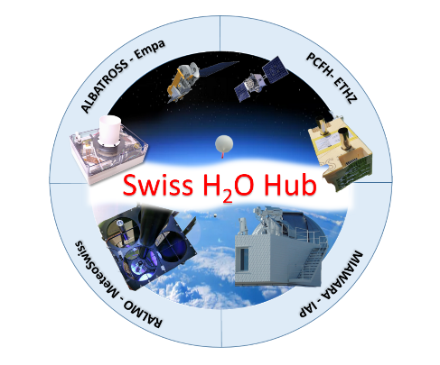
Water vapor (H2O) is an essential climate variable, and it plays a key role in many atmospheric processes in the troposphere, stratosphere, and mesosphere. Tropospheric H2O has the strongest greenhouse effect, and, although it is largely self-regulated by cloud formation and precipitation, it increases steadily due to the warming of tropospheric air. In addition, an increase of stratospheric H2O, caused by methane oxidation or a warming tropopause, is a major driver of the global surface temperature on decadal time scales. Measurement campaigns in Switzerland will be conducted to derive H2O profiles from ground to space by combining the lidar and the two balloon-borne instruments PCFH and ALBATROSS, complemented by RS41 radiosondes in Payerne and the microwave radiometer in Zimmerwald. We will establish harmonized time series to investigate trends and interannual differences in upper tropospheric and stratospheric H2O, including a study of a possible signature of the Hunga-Tonga eruption in the middle atmosphere.
| Period | Partner Organisation | Total volume | Programme |
|---|---|---|---|
| 2022-2027 | University of Bern *Note that MeteoSwiss receives no project funding. | CHF 1'059’070 | GAW-CH and GCOS-CH |
Completed in 2024
Tapping the potential of one decade of annual repeat altimetry to study glacial and periglacial processes (TapRep)
The project focused on a data set of very high-resolution aerial photographs and digital elevation models available at yearly intervals since 2012. This worldwide unique data set covers about 100 Swiss glaciers and proglacial areas. The project developed around four main strands, related to topics encompassing glaciological and periglacial research, as well as data visualization for public outreach. We (1) advanced the extrapolation of glacier mass balance from local measurements to the regional scale, (2) assessed the abundance and formation of surface-collapse features on Alpine glacier tongues, (3) quantified periglacial sediment dynamics at the multi-catchment scale, and (4) performed 3D visualization of annual aerial imagery and terrain models. These interdisciplinary pathways established new links within the academic community, thus ultimately contributing to strengthening environmental monitoring in Switzerland.
Completed in 2023
Rock Glacier Inventories and Kinematics (RGIK)
The project Rock Glacier Inventories and Kinematics (RGIK) laid the foundation for an international service dedicated to the long-term observation of rock glaciers on a global scale. In collaboration with an Action Group of the International Permafrost Association, this project contributed to the development of widely accepted standard guidelines for inventorying rock glaciers and generating kinematic time series in a climate-oriented perspective. This project further led to the adoption of rock glacier velocity as a new associated parameter to Essential Climate Variable (ECV) Permafrost within the Global Climate Observing System (GCOS).
Archiving and publication of Specola Solar Ticinese sunspot activity recordings (ASST)
In climatology, sunspot activity recordings are used for the long-term reconstruction of solar radiation, as the number of sunspots correlates closely with total solar radiation. The Specola Solare Ticinese solar observatory has systematically monitored sunspots since its establishment by ETH Zurich in 1957. Since 1981, its operations have been supported by a local association set up for this purpose called the Associazione Specola Solare Ticinese (ASST). In the context of this project, financial support was provided for collaboration between the ETH Zurich Library and ASST to ensure the long-term archiving, digitisation and publication of historical sunspot images and data.
Discovering forgotten glacier images in a new glance (DEFOGGING)
Glacier retreat is one of the most visible signs of ongoing climate change, and repeated glacier photography is possibly one of the most immediate ways to visualize and communicate the alarming rate of this change. This project set out to guarantee long-term accessibility to a unique record of glacier photographs that have been collected over the years. Starting from a pool of over 50,000 images available at the project’s host institution, the aim was to integrate these historic documents in the Image Archive of the ETH Library. The images were indexed, digitised and georeferenced with the help of volunteers, and made accessible through ETH’s E-Pics platform. This ensures long-term accessibility to a unique set of observations, thus creating added value for both researchers and the general public.
Aerosol Optical Depth data Web Interface for data communication to scientists and the public (GAWaodIDC)
The GAW PFR network is an aerosol optical depth network operated by PMOD/WRC and supported by WMO-GAW and MeteoSwiss. The project GAWaodIDC reported information on the processing chain and metadata for all GAWPFR Aerosol Optical Depth (AOD) measuring stations. This was achieved and is demonstrated through the development of a website that provides new and complete AOD information, at one place (one-stop-shop), together with the full processing chain and meta-data, in accordance with the GCOS-CH strategic priorities 1.5 and 1.6. The interface is also a web tool, including aerosol related applications for different users (scientists, local operators, public).
Enhance existing Swiss precipitation products with particular regards to snowfall
Snow is an important component of the water cycle in Switzerland, contributing approximately 40% of the runoff in Swiss rivers. Measuring snowfall is associated with considerable uncertainties, in particular in mountainous terrain, where undercatch of snowfall can cause biases of several 10%. Unlike other countries, Switzerland does not have monitoring networks to automatically measure snow water equivalent (SWE). However, there are hundreds of stations to measure snow depth, many of which are co-located with precipitation gauges. In the absence of sufficient SWE data, the combination of precipitation and snow depth data along with snow modelling and data assimilation methods enable determining biases in existing precipitation products. The project advanced datasets for one of the most important Essential Climate Variables (ECV) of the country, integrating existing monitoring and modelling systems for the benefit of any project or service that requires national-wide precipitation data as input.
Completed in 2022
Monitoring of Middle Atmospheric Water Vapor
The Institute of Applied Physics at the University of Bern develops and operates ground-based microwave radiometers for continuous monitoring of essential climate variables. This includes the “Middle Atmospheric Water Vapour Radiometer” (MIAWARA) at the Zimmerwald Observatory, which provides data to the international Network for the Detection of Atmospheric Composition Change (NDACC) since 2002. With this project in the framework of GCOS-CH, we ensured the continuity of this unique data record with an upgrade of the instrument hardware and data analysis software.
Fractional snow cover time series (1981 – 2021) – a novel dataset from space to support climate studies in Switzerland
This project generated a 40-year fractional snow cover time series for Switzerland based on Advanced Very High Resolution Radiometer (AVHRR) satellite data, archived at the University of Bern. By doing so, it overcame missing spatial information in Switzerland's dense measurement network of stationary in-situ instruments. Spatial and temporal analysis of the novel snow cover time series for the time period 1981 until 2021 improves our understanding of the variability and changes of Alpine snow cover. Further analysis of the new data set were made in close cooperation with Climate Evolution, MeteoSwiss and serve as improved basis for climate services to enhance our process understanding in the field of snow cover dynamics and its impact on local society. The new data set is publicly available and supports climate studies as an independent data source on snow cover dynamics.
Permafrost monitoring through reprocessing and repetition of geophysical measurements (REP-ERT)
Measurements using electrical resistivity tomography (ERT) make it possible to detect permafrost, i.e. continuously frozen ground, thanks to the very different electrical properties of frozen and unfrozen subsoil. However, the cost of this technique means that there is little continuous ERT monitoring of permafrost worldwide. One of the exceptions are six permafrost sites in the Swiss Alps that have been constantly monitored with ERT in the context of the Swiss Permafrost Monitoring Network (PERMOS) since 2005, enabling analysis of the long-term change in the soil's ice content and associated degradation or freezing processes. In addition, though, there are many permafrost sites (estimated at more than 500) where one-off ERT measurements have been performed in the past. The REP-ERT project demonstrated the potential of these datasets for the climatological analysis of permafrost areas and preserved them for future repeat measurements by incorporating them into a shared database.
Updating the SwissSMEX soil moisture monitoring network infrastructure to secure the continuity of the long-term data series and ensure the data quality
Soil moisture is an essential climate variable (ECV) defined by GCOS. It affects the exchange of moisture and energy between land and atmosphere and plays a crucial role in the development of summer droughts and heatwaves that are a feature of our current climate. Soil moisture is being monitored in Switzerland since 2008 within the SwissSMEX project in 19 soil profiles at 17 stations. These measurements constitute the most important long-term data series of soil moisture in Switzerland. Analyses of these data in the GCOS SMiLE-ECV-CH project with regard to their availability and quality indicated a degradation of the network due to an increasing number of sensor failures over time leading to substantial data gaps. The project secured the continuity and quality of the network in the mid- to long-term by updating the SwissSMEX grassland stations with modern sensors. Their design made for a more consistent network set-up and will facilitate the replacement of failing stations.
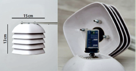
Balloon-borne laser spectrometer for UTLS water research (ALBATROSS)
Water vapor in the UTLS (Upper Troposphere and Lower Stratosphere) is a prominent Essential Climate Variable (ECV) that critically contributes to characterizing Earth’s climate and plays an important role in stratospheric dehydration, troposphere-stratosphere exchange processes, and the formation of cirrus clouds. However, in situ humidity measurements in the UTLS are still very challenging and carry significant uncertainties. The Albatross project is based on our recently developed QCL spectrometer for the measurement of water vapor in the UTLS. This spectrometer showed excellent performance in laboratory experiments and during two demonstration flights. Albatross complemented these results with the following activities: (i) further improvement of the mechanical and optical design, (ii) validation of the instrument with SI-traceable methods, and (iii) improving the spectral retrieval algorithm using more sophisticated line profiles, (iv) participating at the international intercomparison campaign for hygrometers, AquaVIT4, and (v) repeated water vapor measurements in the UTLS. This work was carried out in close cooperation with METAS, MeteoSwiss, and the GRUAN Lead Centre in Lindenberg (Germany).
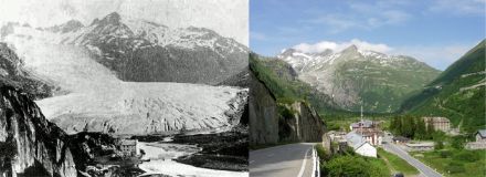
Hundred years of Swiss glacier changes from historical terrestrial images
Switzerland stands out as one of the countries with the longest records of glacier changes, and long-term observations are crucial in order to understand the impact of glacier retreat on water resources or hydropower production. Despite this importance, only a few dozen of glaciers have observations extending further back than three decades. This project exploited a unique archive of 58,000 terrestrial images (TerrA) acquired by swisstopo from 1916 until 1947 for mapping purposes. An automated workflow based on modern photogrammetry techniques was developed in order to document glacier volume changes at a near centennial scale. The methodology was applied to about 20,000 images to provide glacier surface elevation for 45% of all Swiss glaciers for circa 1931. A Swiss-wide glacier volume loss of 0.73 ± 0.08 km3 a−1 and an area reduction of 5.9 ± 0.8 km2 a−1 between 1931 and 2016 was estimated. This translates to a halving of glacier volume compared to 2016, and a third’s reduction in areal cover. The results indicate a strong spatial variability in glacier thinning, with glaciers in the north east losing mass twice as rapidly as in the south west of Switzerland.
Alpine Water Extent and Lake Level Monitoring in Switzerland (AlpineWELLS)
By 2100, due to global warming, the volume of Swiss glaciers will decrease by about 90% since 1985. This represents a massive change in the Alpine region, leading to the formation of several hundred new mountain lakes in previously glaciated areas. In the framework of the AlpineWELLS project, Eawag generated an inventory of glacial lakes for Switzerland and reconstructed the genesis of these lakes back to the 19th century. This inventory incorporates an analysis of glacier lake evolution stages since the Little Ice Age using historical glacier boundaries. The project also proposed a monitoring strategy for glacial lakes, including ground and remote measurements of temperature, turbidity and water-leaving reflectance. Furthermore, bathymetry measurements were carried out to estimate water volume as key natural hazard aspect. These activities are continued beyond the end of AlpineWELLS in the scope of projects supported by the Swiss Federal Office of the Environment (FOEN) and the European Space Agency (ESA).
Improving our understanding and scientific use of two essential climate variables (soil moisture and evaporation) – SMiLE-ECV-CH project
Soil moisture and evaporation from land are two essential climate variables (ECVs) defined by GCOS. They affect the exchange of moisture and energy with the atmosphere and play a crucial role in the development of the summer droughts and heatwaves that are a feature of our current climate and are likely to become more pronounced in future. The SMiLE-ECV-CH project produced an assessment of the potential provided by soil moisture and evaporation observations in Switzerland, focusing on four main topics: performing quality control; determining the land-water balance in Switzerland; investigating the suitability of satellite measurements of the variables; and examining land-atmosphere interactions in dry and wet periods.
Extending the Calibration Traceability of Longwave Radiation Time-Series (ExTrac)
The Baseline Surface Radiation Network (BSRN) is one of several international networks to coordinate the measurement and archiving of radiation data. On a national level, MeteoSwiss conducts radiation measurements at four stations following similar BSRN guidelines. Longwave radiation measurements are conducted with pyrgeometers traceable to the World Infrared Standard Group (WISG) at PMOD/WRC, Davos. The following project developed methods for the traceability of long-wave radiation measurements to all data stored in the BSRN archive. The project activities form the basis for a comprehensive traceability of the long-wave radiation data of the worldwide BSRN network to the International System of Units (SI).
Long Swiss Meteorological Series
The project “Long Swiss Meteorological Series” provided revised as well as new long Swiss meteorological time series that reach back beyond the start of the official Swiss network in 1863.The two only previously available long series, Geneva and Basel, were complemented by digitising additional past segments. Long gaps that were hitherto filled with data from stations that are relatively far away could now partly be filled with data from the cities. Moreover, both series rely largely on few, long segments, whereas there are many further segments in both cases, which help to improve or confirm the quality of the records and support a better homogenisation. In addition to Geneva and Basel, the existing record from the Gr. St. Bernard was back-extended by two years. In addition, the project also provided new, long series. The two most important ones are those from Zurich and Bern, providing temperature records back to 1756 and 1760, respectively (the Zurich series reaches even back to 1708 for pressure and precipitation, though with long gaps). Both are composed of a larger number (17 and 19, respectively) of segments. Finally, the project also contributed to the digitisation and documentation of long meteorological series from Marschlins (1782-1863), Schaffhausen (1794-1845), Aarau (1807-1865), Delémont (1801-1832), Vevey (1805-1840), and St. Gallen (1812-1853) as well as many shorter records. All data have been submitted to the in-situ database of the Copernicus Climate Change Service, MeteoSwiss, and EURO-CLIMHIST. Homogenisation was undertaken for the temperature records from Zurich, Bern, Basel, and Geneva, yielding new and revised, long Swiss records.
Completed in 2021
Harnessing the Power of Crowdsourcing to tackle 21st century mountain observation challenges (POC21)
The project addressed high-mountain challenges requiring the provision of actionable information on Alpine changes. Swiss national monitoring programmes for glaciers and permafrost, GLAMOS and PERMOS, play a fundamental role in the provision of this information, however often lack sufficient real-time in-situ information to develop timely monitoring products. In the framework of the project, MountaiNow – a collaborative platform for sharing mountain observations in real-time - explored the potential of modern observation methods to fill this information gap, and in particular evaluating the power of crowdsourcing for long-term mountain monitoring.
The Global Atmosphere Watch (GAW) Precision Filter Radiometer Network
Aerosol optical depth (AOD) is an essential climate variable of great importance to climate and atmospheric research, as it is one of the main parameters determining the Earth's radiative forcing. AOD is measured using precision filter radiometers (PFRs), thereby contributing to the Global Atmosphere Watch (GAW) programme. The World Aerosol Optical Depth Research and Calibration Centre (WORCC) of the Physical Meteorological Observatory in Davos (PMOD) maintains the PFR standard for measuring AOD. Therefore, this project run by the PMOD/WRC (World Radiation Centre) concluded on harmonization, re-evaluation and improvement of the GAW-PFR AOD time series.
Operational Monitoring of the Rain Rate by Ground-based Microwave Radiometry in Switzerland
The project applied a new method for estimating the rain rate, which can be derived from observations of microwave radiometers in Bern, Payerne and Schaffhausen. The project worked in close cooperation with MeteoSwiss, which runs the operation of the HATPRO radiometers in Payerne and Schaffhausen. The time series of the rain rate for the TROWARA radiometer are established in Bern (since 2004) and for the HATPRO radiometers in Payerne and Schaffhausen (since 2007) and were compared with coinciding measurements of conventional rain gauges. The time series were harmonized to detect possible trends in the rainfall rate. The algorithm for the rain rate was implemented for the operational data processing of the rain rate for the three microwave radiometers, thus enabling a monitoring of the rain rate in near real-time. Furthermore, a HATPRO radiometer at the University of Bern was set up to perform further comparisons between different measurement techniques.
Operational near-real-time glacier monitoring
The 'Operational near-real-time glacier monitoring' project by WSL and in collaboration with GLAMOS aimed to provide observation- and model-based information on the state of Swiss glaciers, with a particular focus on the glaciological mass balance. By providing near-real-time information, the project sought to satisfy the need for knowledge expressed by the media and public each year, especially in the summer months. The project brought together the key aspects of observation, modelling and communication.
Completed in 2020
Compiling historical glacier data
Glaciological measurements in Switzerland go back a long way. Some of the time series were started in the 19th century and are among the world's longest glaciological series. To ensure the quality and interpretability of long data series, it is indispensable that historical glacier data are stored and documented appropriately. While today the collected information contains detailed metadata, for 20th century measurements these are only available to a limited extent, if at all. Accurate documentation is essential to ensure a consistent re-evaluation of the time series with proper quality control as well as to estimate uncertainties. This project processed all direct measurements of the mass balance of Swiss glaciers since the start of the 20th century in full detail. The original observations were tracked down in the archives and the various types of information, such as measurement techniques, underlying assumptions, and the exact time and date of field surveys, were compiled in a detailed dataset. These new data and metadata are stored in an extensive database, which enables a more detailed and carefully documented re-evaluation of long-term time series on glacier mass balance, making them of greater use for global climate monitoring.
Providing Data Provision for a Sensitivity Analysis of Snow Time Series
Like all climate series, snow time series covering many years are affected by changes in measuring locations, observers and measurements techniques. Such non-climate changes may have an influence on any trends that are identified. The project Providing data provision for a sensitivity analysis of snow time series collected data for a sensitivity analysis of snow measurements with respect to non-climate effects. Moreover, thorough metadata compilation allowed WSL SLF to collect information on the history of snow fall and snow depth measurement practices in Switzerland and other countries.
GNSS sensors’ suitability for the automated operational measurement of snow water equivalent in the Swiss Alps
Snow is an essential climate variable that is characterised not only by its depth but also by snow water equivalent (SWE). This is traditionally determined by weighing a snow sample. Recent studies have shown that the SWE can also be worked out using signals from the Global Navigation Satellite System (GNSS). The SWE can be deduced from the difference in signal characteristics that GNSS receivers record above and below the snowpack. In the framework of this project, the SLF in collaboration with its partners assessed the suitability of the automated operational measurement of SWE within the Swiss observational network for SWE.
Integrated Lake Ice Monitoring and Generation of Sustainable, Reliable, Long Time Series
Freezing and thawing data recordings for lakes provide valuable insights into the regional climate. However, a lake's size and geographic location may mean that not all observation methods are equally suited to the task. Based on a previous feasibility study on lake ice, this project run by the ETH Zurich integrated various sensors and methodologies to operationally obtain systematic and reliable observations of lake ice.
Completed in 2019
Development of a communications strategy for the Swiss cryospheric monitoring networks
The Swiss cryospheric observation network covers glaciers, snow and permafrost and is an integral part of long-term climate monitoring in the Swiss Alps. Promoting public awareness of the importance of climate observation is a key factor that will help to safeguard the climate time series over the long term. Therefore, this project run by the University of Fribourg brought together all the partners involved in cryospheric monitoring networks to work out the basic components of a joint communications strategy.
Completed in 2018
Securing long-term permafrost monitoring at the Tsaté site in the framework of PERMOS
The systematic documentation and monitoring of mountain permafrost in the Swiss Alps is handled by the Swiss Permafrost Monitoring Network (PERMOS). The extreme conditions in a high Alpine environment mean that the measuring systems have to be regularly overhauled or even completely replaced. An example of this was the 2004 borehole at Tsaté, where there were increasing inconsistencies in the temperature time series. It was not feasible to calibrate or replace the thermistor string, which was stuck in the borehole. Instead, in the framework of GCOS-CH, MeteoSwiss provided support to enable the University of Lausanne to replace the borehole.
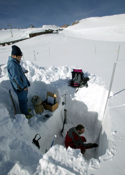
Quality assurance of long-term snow water equivalent measurements
Snow water equivalent (SWE) measurements play a key role in flood forecasting, snow load standards and the validation of remote sensing data. SWE data are currently collected manually. However, not only is this very time-consuming but it is becoming increasingly difficult to find staff to consistently conduct measurements throughout the season. Therefore, as part of this SLF project, several automated monitoring techniques were compared with conventional measurement instrumentation.
Comparison of spatially high-resolution measurements of snow distribution using manual and laser- and drone-based measurements in the Wägital
The time series covering snow density, snow water equivalent and snow depth for a catchment area in the Wägital valley is longer than any other in the world. However, manually recording snow depth is fraught with considerable uncertainties. One alternative is drone-based monitoring, enabling cost-effective, high-resolution estimates of snow depths. The aim of this joint SLF/Meteodat GmbH project was to evaluate the potential of this drone-based method.
Processing and standardising historical time series documenting length variation in Swiss glaciers
In the context of glacier observation since the 1880s, the change in the glacier tongue position was systematically documented, and the length variation was worked out from this. However, the length variation data were not georeferenced and were often incomplete. Therefore, this project run by ETH Zurich systematically processed and standardised the historical length variation time series.