Service Navigation
Search
The Federal Office of Meteorology and Climatology, MeteoSwiss runs a quality-controlled Climate Observation Network, which has been expanding continuously since 1864 and will continue to do so into the future. This network is the cornerstone of all the observations and analysis of climate and climate change undertaken in Switzerland. MeteoSwiss provides monthly and annual reports that give information on the latest climate status. The Swiss Weather Archive contains all annual reports since measurements began. MeteoSwiss describes the current climate in line with the specifications of the World Meteorological Organisation (WMO), using measurement data from the period 1991-2020. The main characteristics of the Swiss climate are depicted and described in detail below.
Temperature
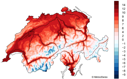
The average temperature across Switzerland for the years 1991-2020 is 5.8°C. The annual mean in the Swiss lowlands is 8-12°C. The highest temperatures north of the Alps are reached in Western Switzerland along Lake Geneva and at the southern Jura foothills, in the Basel region and in the Foehn valleys along the Rhine and Reuss rivers. The annual averages in the lower-lying areas around the large Ticino lakes and Lower Valais are somewhat higher. In the pre-Alps and Alps, the annual mean temperature is decreasing with height. In the highest regions of Switzerland, the average temperatures are significantly below freezing.
Where and when heatwaves occur
The highest temperatures are recorded in July and August in the lower-lying regions of the country. Average maximum temperatures of around 25°C and more are possible in the lower-lying areas on the south side of the Alps and in central Switzerland. June, July and August are typically the months in which the longest and most intense heatwaves occur, with maximum daily temperatures of more than 30°C. In settled weather conditions, the maximum temperature can increase on a daily basis, reaching above 35°C in some locations. Heatwaves present a health risk to humans, and cause stress for animals and plants. On the south side of the Alps, in the period 1991-2020 there are around 10-20 days per year on average where the temperature reaches 30°C or more. Central Switzerland has somewhat fewer hot days. There are very few hot days at altitudes above 1,200 MASL. Heatwaves have become substantially more frequent and intense since about 1980 because of climate change.
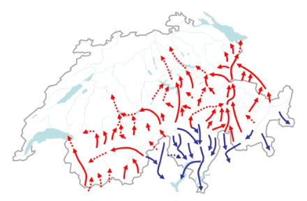
The climate of Switzerland is primarily the result of the country’s geographical location in the mid-northern latitudes of central Europe, along with its complex topography of high Alpine peaks and deep valleys. The geographical positioning determines the solar radiation over the year, and thus the seasons and the day lengths. The local weather conditions, on the other hand, are dependent on both the geographical location and the season. The varied topography of the Alpine region makes for regional differences in weather. There are also regular features of the climate that are peculiar to Switzerland (Regularly occurring weather conditions), such as the cold spell in June known as the “Schafskälte” or the spate of frost days which occurs in May, known as “Eisheiligen”.
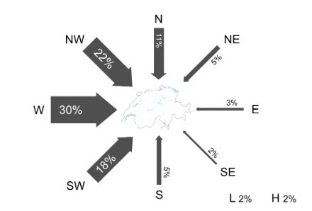
The climate of central and northern Europe, including Switzerland, is heavily influenced by the Atlantic Ocean. Switzerland is located in the West Wind Zone, which is why for most of the year air masses arrive in Switzerland from the west, whereas air currents from easterly, northerly and southerly directions are comparatively rare. High or low pressure systems centred directly over Switzerland are also comparatively rare (2% of the direction of the air currents, which amounts to around one week per year).
On prevailing currents from westerly and northwesterly directions, mild, humid sea air travels across Switzerland. These have a cooling effect in the summer, and a warming effect in winter. In the summer, when the strong, westerly high-altitude winds (the jetstream) move further north, as they normally do, Switzerland is dominated by a continental climate with a distinct diurnal cycle in temperature and precipitation. During this season precipitation often falls in the form of thunderstorms in the latter half of the day. Over the course of a year, most areas in Switzerland receive sufficient precipitation to meet the needs of industry and the population. The Alps act as a prominent climatic barrier between northern and southern Switzerland.
Southern Switzerland is mainly affected by the Mediterranean Sea, where the climate differs from that of the north, most notably in its significantly milder winters. The south side of the Alps is also known for its heavy precipitation in conjunction with low-pressure systems in the Gulf of Genoa, and when moist air masses move up over the southern Alps during southwesterly flow or southerly Foehn conditions..
Where cold is the order of the day
In Switzerland’s higher-altitude regions, the cold is a prominent feature of the climate. In the lowlands, frost and ice resulting from cold snaps are a problem for agriculture, the human population and infrastructure alike. The coldest temperatures are recorded in January and February. The most severe cold waves are often associated with the inflow of cold air from a northerly to easterly direction. In the north part of central Switzerland the average minimum daily temperature is only slightly below 0°C between December and February, whereas it is somewhat higher in the lower-lying areas of Ticino. Cold air can accumulate in valleys and hollows, which, after several days’ build-up, can lead to temperatures far below freezing.
The CH2025 climate scenarios show that Switzerland is a hotspot of climate change. In Switzerland, temperatures have risen by 3.0 °C since the beginning of measurements up to 2025, significantly more than the global average (1.4 °C). This trend will also continue in the future. The altitude of the zero-degree isotherm is climbing. The result of this is that winter precipitation in lower-lying areas falls more often in the form of rain rather than snow. Heavy precipitation events have increased in both intensity and frequency. This is another change that will become more pronounced in the future. Summers are becoming hotter and drier overall. If we are to curb the consequences of climate change in Switzerland as well as the rest of the world, global efforts are needed to reduce greenhouse gas emissions.
Precipitation
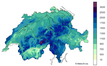
The highest annual precipitation amounts are observed in the Alps, the Alpine foothills, on the south side of the Alps and across the western peaks of the Jura. These regions normally have annual totals of around 2,000 mm of precipitation. In the northern plateau, the average amount is around 1000 to 1500 mm per year. The annual precipitation sum falling over the whole of Switzerland is roughly equal to the capacity of Lake Constance. Nearly everywhere in Switzerland, more precipitation falls in the summer than in the winter. The reason for this is the greater availability of water in the atmosphere due to higher temperatures and heavy thunderstorms. In the other months, it is mainly the low-pressure systems and associated cold and warm fronts that cause precipitation.
Climate diagrams can be helpful when planning travel, for example. They provide useful information for holidaymakers in Switzerland, and for anyone wishing to know what kind of climate to expect in a given locality.
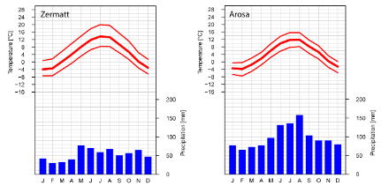
The Alps act as a climatic divider between north and south, and thus create an additional climatic region, namely the inner-Alpine valleys. These valleys are well-protected against moist air masses from the north and the south, and so have very dry conditions. Typical examples of these dry valleys are the Rhone Valley in the Canton of Valais in the south-west and the Engadine in the south-east of Switzerland. In the Rhone Valley, the average precipitation is between 550 and 700 mm per year, depending on the particular area, while in the Engadine it is between 700 and 1000 mm per year.
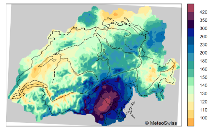
Heavy precipitation are normally associated with rare precipitation events that last anywhere between a few minutes to several days and can cause flooding and/or landslides or mudslides. Heavy precipitation is defined with different thresholds depending on the specific application. The heaviest precipitation events occur in Ticino. The long-term average hourly maximum precipitation reaches 30 mm or more at some measurement stations in Ticino. This corresponds to a heavy daily precipitation amount in central Switzerland. The greatest amounts of one-day precipitation are often recorded in autumn on the south side of the Alps with southerly currents. To the north of the Alps, large volumes of precipitation are often associated with thunderstorms and so they often occur in summer.
Extreme precipitation events
In extreme value analyses, the greatest amount of precipitation within a year is used to determine how often (with which return period) certain precipitation amounts (return values) are exceeded for different duration stages and over the entire measurement period. This information can be used for flood risk assessments, among other things.
In the northern Central Plateau, a daily precipitation of 100 mm is exceeded approximately every 100 years. In the western Ticino, especially in the Centovalli, a 100-year event corresponds to more than 300 mm in daily precipitation totals. In the Central Plateau, daily totals of 60-70 mm are exceeded about every ten years. In Ticino, a 10-year precipitation event provides 200 mm or more of precipitation per day.
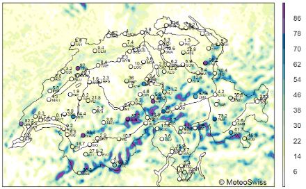
Hail causes damage into the millions
When thunderstorm clouds get tall enough, graupel or hailstones can form. Hailstones cause millions of francs’ worth of damage every year in Switzerland, mostly occurring in the summer months. Depending on the size of the hailstorm and the distance it travels, hail can be very localised or occur over wider regions. The Napf, Ticino and Jura regions all tend to be hotspots for hailstorms. These areas normally have around two to four days of hail a year in the summer months. Very large hailstones with a diameter of up to 4 to 5.5 cm occur about once every 10 years. The extent of the damage that hailstones can cause depends not only on the size but also on the amount of hail falling in a particular area. Hail rarely occurs in the Alps.
Drought affects agriculture and other industry sectors
Depending on its duration, drought affects agriculture, forestry, water and energy supplies and shipping to varying degrees. For this reason, there are different definitions for drought. Meteorological drought is defined as a lack of precipitation that continues over several months or years.
Longer periods without precipitation are more common on the south side of the Alps than in the north of Switzerland. In the south, periods with no precipitation for over a month occur every few years. The longest period without precipitation to date was in Lugano from December 1988 to February 1989, lasting a total of 77 days.
Sunshine
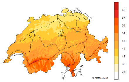
The sunniest locations in Switzerland see an average of 2,000 hours or more of sunshine per year. This includes regions within Ticino and the Valais. The amount of solar radiation that a place can receive depends on the position of the sun and the amount and duration of shadow from surrounding mountains, as well as the direction that the slope is facing.
The term “relative sunshine duration” refers to the amount of actual sunshine in relation to the maximum possible sunshine duration. Relative sunshine duration is dependent on the weather, and specifically, cloud cover. The highest relative sunshine duration is recorded in the dry valleys of the inner Alps, for instance in the Rhone valley and the Engadine, as well as on the south side of the Alps. In the northern part of central Switzerland, where low-lying stratus cloud is a regular occurrence in the colder half of the year, the relative sunshine duration is accordingly low.
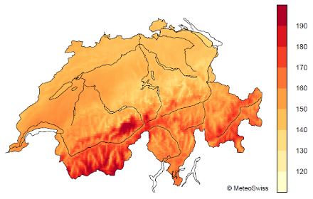
The term global radiation is used to denote the total solar radiation received by a measuring device. It represents the sum of direct solar radiation and shortwave diffuse radiation that reaches the surface of the measuring device after diffusion via clouds and soot or other particles. The information thereby ascertained is useful for planning the installation of photovoltaics and solar heating panels. The highest levels of global radiation in Switzerland occur in the higher-altitude Alpine regions.
Sonnendach.ch is a website that shows how much electricity or heat the roof or facade of a building can produce at every address in Switzerland.
Fog and low stratus
Fog commonly occurs in the cold months of the year. From late autumn through to spring, low-lying fog regularly forms, predominantly in high pressure areas. This tends to occur mostly along rivers and lakes as the air above these is very damp.
Low-lying stratus cloud is often created in connection with cool, dry easterly or northeasterly winds. The dry air of the “Bise”, as the northeasterlies are known, causes low-lying fog to rise, and the stronger the Bise, the higher the top of the cloud layer will be. Strong, persistent Bise wind can mean that the low cloud cover does not lift for several days or even weeks. The northern part of central Switzerland and the southern foot of the Jura are particularly affected by this phenomenon. Inversions occur as a result of the low stratus: meaning that the sun shines above the stratus, e.g. in the Alps, and the air is warmer above than below it.
Weather is the term used to describe the state of the atmosphere at a given point in time. On the other hand, the climate is described using long-term statistical properties (norm values, deviations from the norm, extreme values and record occurrences) for various meteorological parameters including temperature, precipitation and sunshine duration. The characteristics are calculated according to global standards which use the same 30-year period. This enables the comparison of the climate of different regions. Average values from these so-called normal periods are also known as climate normals. Because the climate is currently undergoing change, the normal periods are updated every ten years.
Wind
The predominant wind directions at surface weather stations are dependent partly on the geographical situation, and partly on the location of the weather station and the nature of the surrounding land (e.g. altitude, valley direction, exposure). Close to the surface, the wind therefore often blows in from a westerly to southwesterly or northwesterly to northeasterly direction in many parts of Switzerland.
The wind direction heavily influenced by the prevailing weather situation and the exposure of the measurement station. For many days of the year there is only a very light breeze in the lower-lying areas, so the annual average wind speed is below 10 km/h almost everywhere in central Switzerland. Higher wind speeds are recorded at weather stations located on the mountain peaks.
Strong winds can cause damage, with a greater likelihood of damage at wind speeds of over 75 km/h. This threshold is exceeded on an average of fewer than 14 days per year in most places in central Switzerland. In some parts of the Alpine foothills, the figure is more than 30 days per year, and on the Alpine peaks, wind speeds reach over 75 km/h about once every six days or fewer, on average.
During a thunderstorm, the top wind speeds are often very localised and shortlived, and are therefore difficult to record. In the context of strong areas low-pressure systems, wind speeds reaching 100 km/h and more can occur over the whole of Switzerland and last several hours or days. Such storms occur mainly in the winter months in Switzerland, and can be extremely destructive to infrastructure, forests or agricultural land over wide areas. The most severe storms in recent history have been Lothar (in December 1999), Vivian (February 1990) and Burglind (January 2018).
Foehn wind is a special feature of the Swiss climate. This wind that crosses the Alps creates distinctly mild and dry conditions on the leeward, downwind side, often blowing at high speeds. There is a southern foehn and a northern foehn. The southern foehn gives rise to warm conditions on the north side of the Alps, and occurs primarily between autumn and spring. The most significant effects of the foehn are seen in the north-south aligned foehn valleys, e.g. in the Reuss and Rhine valleys. The northern foehn is a major climatic factor in southern Switzerland, particularly in the six months around winter, and often brings good weather and mild conditions lasting a few days.
Snow
Starting at an altitude of 1,200-1,500 MASL, precipitation during winter predominantly falls as snow, such that a solid layer of snow often covers this area for weeks, and even months at higher altitudes. Snowfall is relatively rare in the low-lying areas of western Switzerland (greater Geneva area) and northern Switzerland (greater Basel area) as well as in the lowland in the southern tip of Switzerland. In these warmer regions - mainly because of their low elevation - completely snow-free winters are not uncommon. Due to climate change, the altitude of the zero-degree isotherm is climbing, and with it the snow line, which means that precipitation is now falling as rain at higher altitudes more often than before, and winters with little snow are more frequent.
Phenology and pollen
The distribution of plants and their life cycles during the year are directly related to the climate and the weather in a given region. The large regional differences in temperature, precipitation and sunshine in Switzerland have meant that different plant species have established themselves and spread in different regions over the past decades and centuries. This is why certain plants are found at certain altitudes in Switzerland.
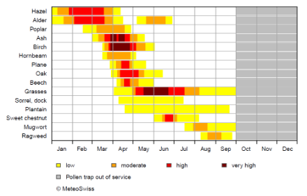
For those suffering from pollen allergies, this means that there are varying levels of risk for hay fever depending on the particular area. The start and end points for the pollen season and the different phenological phases during the year vary according to the annual cycle of temperature and precipitation. Moreover, there are significant differences from year to year and from region to region.
In lower-lying areas, the vegetation period starts earlier and ends later than in the Alpine foothills and the Alps. In central and eastern parts of central Switzerland, the pollen season generally begins with hazel and alder in January. From March, the presence of birch pollen, among others, can be detected. Grass pollens are typically present from April, and can be problematic for many sufferers until the end of August or September.
One effect of climate change is that the vegetation period is starting earlier and lasting longer, which means that plants that are found in lower-lying areas are also becoming more abundant at higher altitudes.
Pollen calendars provide a handy overview of which types of pollen are present at which times of the year.
Recurrent idiosyncracies of the Swiss climate
The climate of Switzerland has many idiosyncratic features that occur regularly – including snowfall in spring, the cold snap in June known as the “Schafskälte”, the frost days in May known as “Eisheiligen”, the Indian (or “old wives”) summer in autumn, and the first fresh snow of the year. These weather features are described and analysed in more detail in the weather and climate glossary.