Service Navigation
Search
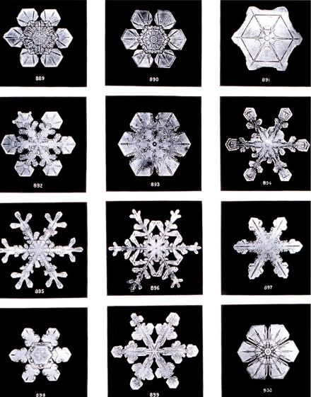
Snowflakes and ice crystals
Snow is a solid form of precipitation. A snowflake consists of several hexagonal ice crystals. The shape it takes depends on the particular weather conditions. How the different ice crystals form depends mainly on the humidity and the temperature. Depending on the combinations of these two parameters, ice crystals take the shape of rods, platelets, flakes with six arms resembling small roof tiles, or dendritic shapes/stars.
Generally speaking, we talk about snow when the snowflakes are at least one millimetre in diameter.
Soft hail or snow pellets
Occasionally we see small, white pellets falling from the sky that look something like polystyrene balls. This type of precipitation is known as soft hail or snow pellets, which, in contrast to hailstones, can be pressed together. It can occasionally occur in winter and spring in convective weather conditions with a warm, unstable air mass that has high humidity. Snow pellets are formed when large snowflakes collide with each other. The outermost “branches” of the snowflakes melt, leaving a compact nucleus of snow.
Influence of atmospheric conditions on the ice crystals
Besides water vapour, the atmosphere (at around 10 km up) also contains aerosols [Link Wetterlexikon Aerosols], which serve as condensation nuclei. The water vapour condenses around these nuclei when the air temperature drops. Small droplets form, which are much smaller than raindrops. If the temperature is below zero, a tiny ice crystal (known as a freezing nucleus) forms in place of a droplet. Ice crystals that join together become larger and heavier. Once they have reached a certain weight, the snowflakes begin to fall towards the Earth’s surface as “hydrometeorites”.
To begin with, the ice crystal falls at the speed of a few centimetres per second. On its long journey towards the ground, it encounters various temperature and humidity conditions. This causes the crystal to undergo a series of changes.
Snow cover
The temperature of both the air and the surface of the ground, as well as the intensity of precipitation, influence how long snow stays on the ground (temperature below or slightly above zero) and how high the snow cover becomes. The lower the temperature, the lighter the snow and the higher the air content of the snow cover. Conversely, the higher the temperature, the more compact the snow and the higher the water content of the snow cover.
If the air that the snow falls through is above zero, the snow begins to melt. Since snowflakes don’t all melt at the same rate, there is a transition zone between snow and rain. The elevation at which precipitation is 50 percent rain and 50 percent snow is called the snowfall limit in weather forecasts.
Why is snow white?
Snow consists of millions of different, transparent ice crystals that are chaotically arranged and do not absorb any colours. They reflect and refract the rays of the sun in a random way, resulting in a diffuse reflection that consists of all colours in the spectrum. The human eye perceives this reflection as perfect white.
Types of snow
From a physical perspective, snowflakes are frozen water in the form of tiny, often intricately detailed ice crystals (see above). When these ice crystals accumulate on the ground, they form a blanket of snow known as snow cover. Snow cover consists of countless snowflakes.
Depending on the altitude, temperature, moisture content and other environmental factors, snow cover can have widely varying properties. It can be soft, icy, wet or hard. When we examine snow through a microscope, it opens up a whole new world.
- Dusting: Dusting is a sparse covering of snow on the ground. We may think of dusting as powder snow, but in the meteorological context, the term is also used when just a few centimetres of wet snow have accumulated on the ground.
- Powder snow: Powder snow falls onto cold ground at zero degrees or sub-zero temperatures. This soft type of snow is so light that it flies into the air when you blow on it.
- Heavy snow: Heavy snow occurs in two ways: either when snowflakes melt as they fall through a mild air mass and become wet, or when temperatures rise and powder snow on the ground begins to melt (the melting process makes the snow cover moist).
- Ice snow: Ice snow forms when moist or wet snow on the ground freezes due to a drop in temperature (e.g. during the night). New ice crystals form in the snow cover. At the end of the process, the snow is known as metamorphosed snow, which is a class in its own right. The constant day-and-night cycle and temperature fluctuations continue to exert their influence and transform the snow from day to day.
- Hard-packed snow: Wind and moisture change snow constantly, which results in a hard crust on the surface.
- Corn snow: When temperatures rise, a type of snow known as “corn snow” forms on many a ski slope and in the general landscape. This snow is relatively moist snow that is thawed on the surface and is soft but somewhat heavy. It forms when the sun warms up the snow during the daytime. Soft corn snow can be fun to ski on if it has not yet become too wet and heavy. Ski resorts often have corn snow in the spring, although this year it was present even at the beginning of January because of the very high temperatures for that time of year.
- Wet snow: Wet snow can result when rain falls onto existing snow cover. It can also form when snow thaws due to rising temperatures. This type of transformed snow has a high water content and is heavy.
- Firn snow: Firn snow is a type of snow that is at least one year old and has therefore gone through at least one summer. Firn therefore only occurs in high mountainous areas. It is snow that has lasted for several years and has not yet metamorphosed into glacier ice. Firn forms when fresh snow falls repeatedly onto an existing layer of snow and exerts pressure on the old snow. When the weather warms up and the snow thaws, large, granular ice crystals form in a process known as “firning”. So why do skiers actively seek out firn snow? Because firn snow is also popularly associated with the buttery, soft surface on hard ground that forms during the day in spring when the sun softens the hard snow cover. This thin layer of snow – which is actually corn snow (see above) – is particularly good for skiing on.
- Old snow: In contrast to fresh snow, old snow has lain on the ground for weeks, months or even years. Old snow has been substantially metamorphosed and its structure and density have undergone significant transformation. For example, the snow crystals are no longer clearly visible and are less branched.
Snow cover measurements
At some weather stations in the MeteoSwiss monitoring network, measurements of snow depth are carried out manually. These take place in the morning at 6 a.m. UTC (7 a.m. local time in winter, and 8 a.m. local time in summer). The overall height of the snow cover is measured, as well as the depth of new snow that has fallen in the past 24 hours (from 6 a.m. to 6 a.m. UTC).
Further information on manual snow measurements: MeteoSwiss’s monitoring handbook (german) from page 195.The evening monitoring described in the text was discontinued several years ago.
The Alps often act as an obstruction to precipitation. For instance, with a northerly upper air flow, heavy snowfall, sometimes record amounts, can be seen in the mountains on the northern side of the Alps during the winter or at the beginning of spring. The deepest snow cover is usually seen between March and May, depending on the year and elevation.
Influence of global warming
Even though periods of heavy snowfall still occur, the increase in Switzerland’s average temperature is having a noticeable impact on snowfall, especially at low elevations. This is demonstrated by the climate indices [interner Link Klima] for days with fresh snow [interner Link Wetterlexikon] and the number of days with snow cover.
Warnings of heavy snowfall
If snow is forecast, warnings of between Level 2 and Level 5 are issued, depending on the amount of snow expected. Higher warning thresholds apply for the mountains (above 800 m on the northern side of the Alps and above 1,600 m on the southern side), as snowfall there is more frequent and heavier than in the lowlands. As far as lower elevations are concerned, the threshold values for German-speaking Switzerland and the Fribourg region are somewhat higher, as snowfall down to the lowlands occurs more frequently in those areas than in other low-lying parts of the country. If the expected snow amounts are below the Level 2 warning threshold for snowfall, Level 2 warnings of slippery roads are issued. When warnings are issued for heavy snowfall or slippery roads, it is important to follow the recommendations for action.