Service Navigation
Search
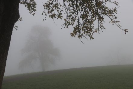
Fog is formed when water vapour condenses in the layer of air closest to the ground. In terms of its physical properties, fog is no different to low stratus or cloud. They all consist of minute water droplets that float in the air and reduce visibility.
When visibility is less than 1 km, this is referred to as fog. Fog layers can be a few metres to several hundred metres thick.
Fog can form and dissipate as a result of fluctuations in air temperature and/or the amount of water vapour in the air (absolute air humidity). From a physical perspective as regards temperature fluctuations, the cooler the air, the more water vapour it can contain. When a “packet” of air cools, it is saturated with water vapour, which condenses into droplets and thus into fog. In this case, the relative humidity is 100%. On the other hand, when the relative humidity is already 100% and there is fog, if the air temperature rises, then this air will suddenly be able to hold more water vapour. The droplets thus start to evaporate, and the fog dissipates.
This phenomenon can also happen in connection with a rise or drop in air humidity. When we consider a “packet” of air in a particular location with a specific air humidity and temperature, we can see, for example, that the wind can bring in air that is much more humid, which will then increase the relative humidity. When this relative humidity reaches 100%, fog begins to form. On the other hand, fog can disperse if it meets the foehn, a very dry wind, which causes the water droplets in the fog to evaporate.
Low stratus – when the fog is not at ground level
The term “low stratus” is used when the fog layer is resting a little way above the Earth’s surface. There is no reduction in visibility at ground level with low stratus. In regions characterised by low stratus clouds, typically situated between altitudes of 100 meters and 500 meters, elevated locales within this stratus layer often experience fog formation. The weather forecast reports the altitude of the top of the fog layer.
When the stratus top is around 2,000 m.a.s.l. or higher, meteorologists usually refer to low stratus-like cloud and do not give the height of the stratus top.
Fog days – days with poor visibility
A fog day is when fog has been present at one of the three daily observation times (morning, noon, evening). This means that days on which fog dissipates in the early morning, followed by sunshine, are also counted as fog days for statistical purposes. In contrast, days with low stratus clouds are usually not counted as fog days, as the visibility tends to be greater than 1 km. In the low-lying areas on the northern side of the Alps, fog occurs particularly frequently in the autumn months.
Types of fog
In addition to its altitude, which sets it apart from low stratus clouds, fog is also categorised based on its formation process. There are several different types of fog.
Radiation fog
Radiation fog usually forms after sunset, on a day when the ground has radiated its warmth to the surrounding atmosphere. This process mostly occurs in autumn and winter, when the long nights lead to a significant cooling of the lower layers of the atmosphere. As the air cools, its relative humidity increases, and when it reaches 100%, a very shallow and low-density layer of fog begins to form near the Earth’s surface, sometimes only a few dozen centimetres thick. When this layer reaches a thickness of at least two meters as it continues to rise, it is sometimes referred to as “ground fog”. If it continues to expand vertically, a fog layer can grow to several hundred meters. Throughout the day, the incoming sunlight warms the upper surface of the fog. The resulting mixing of the fog layer then promotes the dissipation of the fog layer during the daytime, often around midday.
Advection fog
Advection fog forms when milder air arrives that has a higher moisture content than the existing air at a particular location. This incoming air cools upon contact with the existing colder air, leading to an increase in relative humidity. When the relative humidity reaches 100%, the condensation process begins, forming banks of fog.
Lake or sea fog
Localised lake fog forms when cold air flows over the surface of a much warmer body of water, such as a lake. In Switzerland, this type of fog occurs only very rarely in the vicinity of larger lakes. This fog phenomenon is more common in Northern Europe in particular and is often associated with the passage of Arctic air over the sea, especially in autumn when the sea is still warm. As in the other cases, the air cools near the water’s surface, causing it to hold less water vapour and thus rapidly triggering the condensation process and fog formation.
Frontal fog
Frontal fog forms when precipitation falls into relatively dry, cold air at the layer closest to the ground. The droplets then evaporate into water vapour, and once the air is saturated, fog banks form. This phenomenon often occurs with warm fronts, especially when there is no wind, and rain from the warm air mass falls into the cooler and stable air mass below.
Freezing fog
Freezing fog occurs when the droplets within the fog are in liquid form but are located in an area with sub-zero temperatures. These droplets freeze immediately when they come into contact with the ground or with objects, forming ice deposits known as frost.
Ice fog
Ice fog is a very rare type of fog. It occurs more frequently in mountainous regions, where the droplets in the air are frozen. For it to form, temperatures typically need to be below -30/-40°C, which is why it is primarily seen in the Arctic, although it can also occur in Alpine areas during winter in very specific conditions. It is a form of precipitation composed of ice needles, which means it can significantly reduce visibility.
Fog: a detailed explanation
The phenomenon of fog gives rise to many questions. Why is there often fog or low stratus on the Swiss Plateau in autumn and winter? Why is it so difficult to forecast fog? You will find the answers to these questions and more on the pages below, which relate to fog and associated phenomena.