Service Navigation
Search
MeteoSwiss has been observing Switzerland’s climate systematically since 1864. It analyses the current weather in the context of long-term climate change using the parameters of temperature, precipitation and sunshine duration. The Climate Monitor makes it possible to see how these three parameters deviate from the mean value for the period of 1991–2020.
MeteoSwiss provides this information in various formats: as a map of the current monthly deviations for the whole of Switzerland, as a time series of the monthly deviations over the last two years for the various forecasting regions, and under the local forecasts for all locations and postcodes in Switzerland.

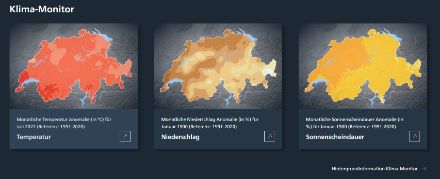
The monthly deviations of temperature, precipitation and sunshine duration can be displayed for the whole of Switzerland. All values shown are for the previous month.
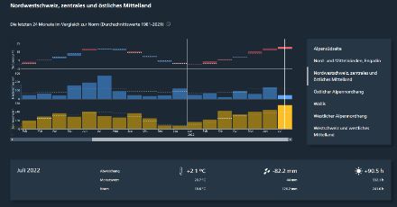
The change in temperature, precipitation and sunshine duration over the course of the last 24 months can be displayed graphically. Information is available for different forecasting regions. In addition, the values for each locality in Switzerland can be seen under the local forecasts.
So-called climate normals are used to put the current weather into context. Climate normals are the averages for temperature, precipitation totals and sunshine duration over the 30-year period between 1991 and 2020 for the relevant month.
The Climate Monitor shows the annual cycle of temperature, precipitation and sunshine duration as deviations of monthly means from the average values over the period of 1991–2020 for individual postcodes. Because MeteoSwiss does not operate a monitoring station in every municipality, the values for the individual postcodes are derived from available measured data. To do this, the data from the monitoring stations are first transferred onto a country-wide map of Switzerland.
The deviations of the daily temperature, sunshine and precipitation graphs from the average values can also be displayed for the individual monitoring stations.
How has the climate changed since the start of systematic observations?
Long-term data series are key when it comes to understanding current climate events in the context of long-term change. In 1864, the Swiss Society for Natural Sciences established a climate monitoring network that operated according to standardised criteria. The monitoring network has been progressively expanded since 1864, and MeteoSwiss continues the observation work today using modern measuring instruments. One of the benefits of this network is that it has formed the basis for drawing up Switzerland’s Climate Change Scenarios. These make it possible to assess the climate change-related risks and opportunities for Switzerland and to decide on mitigation and adaptation measures.
It is generally getting warmer
Clear trends can be identified for some measured variables if we look into the distant past. The temperature in Switzerland has risen sharply since measurements began. The current climate mean is already 3.0 °C above the pre-industrial average of 1871-1900 (as of 2025). For the last ten years (2016-2025), the increase is 2.8 °C. Since the 1960s, each decade has been warmer than the last. This change can only be explained by taking into account the emissions of greenhouse gases by humans. The mean global temperature is expected to continue rising in the future. Just how much it does so depends on whether emissions continue to increase unchecked or are drastically reduced. In the scenario with consistent climate change mitigation, warming in Switzerland can be limited to less than 2°C compared to today’s levels.
More precipitation in winter and for isolated weather events
The precipitation amount varies considerably from year to year – much more so than the annual temperature. This means that long-term and systematic changes in precipitation are much more difficult to identify. As a country-wide average, winter precipitation has increased since measurements began in 1864. In the other seasons, no statistically significant changes in mean precipitation can be identified in Switzerland as a whole. However, heavy precipitation events have become more intense and more frequent. Snowfall is less frequent today, and snow lies for a shorter time in many places than it did in the 1960s.
More sunshine since the 1980s
The Swiss climate monitoring network has also been recording sunshine duration for many decades. Sunshine duration declined in the 20th century and reached its lowest point around 1980. Since then, an increase in sunshine duration has been observed at some locations.