Service Navigation
Search
In most areas, foehn only occurs on one side of the mountains because of the prevailing wind direction. However, Alpine foehn is a well-known phenomenon that occurs on both sides of the mountains. Named after the primary direction from which it originates, the southerly foehn blows on the north side of the Alps and the northerly foehn on the south side of the Alps.
Southerly foehn – origin and typical characteristics
With a typical southerly foehn, there is usually a strong area of low-pressure around the Bay of Biscay or over the British Isles. Generally speaking, the low-pressure system moves only slowly eastwards or north-eastwards. The cold front associated with the low lies over France and moves slowly eastwards. Ahead of the cold front is a southerly current that moves across the Alps.
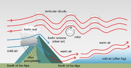
On the southern side of the Alps, the lower air layers are cold. The moist, mild air masses flowing in from a southerly direction in the upper layers of air accumulate at the Alps, resulting in moderate to heavy rain. A bank of clouds known as the foehn wall appears on the Alpine ridge from the northern side.
Precipitation on the southern side of the Alps spills over into the areas immediately north of the main Alpine ridge. Different areas are affected depending on the strength and, in particular, the direction of the wind: with south-easterly winds, it is mostly the Upper Valais up to the Central Valais and the Grimsel area that are affected; with southerly winds it is the Uri Oberland (Urseren) and the upper and southern Surselva, and with south-westerly winds, large parts of Central Grisons and the Upper Engadine.
North of the main Alpine ridge, the air masses sink and become warmer, and the clouds dissipate. This area of very clear air and almost blue skies is called a foehn window. As the air passes over the Alpine ridge, lee waves form in the atmosphere. In the area of the wave ridge, characteristic lenticular clouds (altocumulus lenticularis) often form, which are popularly known as "foehn fish".
In the foehn valleys on the north side of the Alps, foehn storms are not uncommon. At the typical foehn location of Altdorf in Uri, the strongest winds of the year can reach between 100 and 140 km/h.
Now and then, the southerly foehn is accompanied by very little to no precipitation on the south side of the Alps. When a typical southerly foehn occurs, the influencing low-pressure area and its associated cold front lie somewhat further away from the Alps.
Southerly foehn also occurs without any precipitation whatsoever when there is a high-pressure area over south-eastern Europe (anticyclonic foehn). Dry air flows over the Alps from the southeast, which means that on the south side of the Alps, conditions are often practically cloudless, with no precipitation. This results in extremely low relative humidity in the foehn valleys on the north side of the Alps. With typical foehn, humidity is usually in the range of 30-40%. During anticyclonic foehn, the relative humidity can drop to 10-20%, and in rare cases even lower.
Northerly foehn – origins and typical characteristics
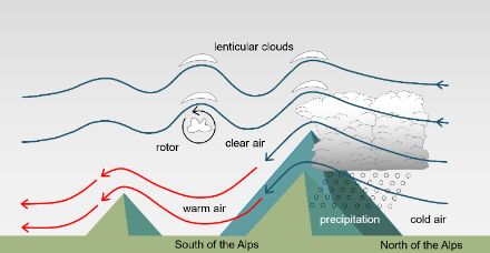
The typical northerly foehn is triggered by an area of high pressure over the Western Europe/Atlantic region. It brings cool, humid air from the North Sea area towards the Alps. The air masses cross the Alps from north to south, and the area of accumulation, with clouds and precipitation, lies over the northern slopes of the Alps. The thickness of the cloud layer decreases rapidly the further away it moves from the Alps. By the time it reaches the Jura, the cloud cover is usually already broken up.
With a northerly foehn, the largest amounts of precipitation are recorded on the central and eastern slopes on the north side of the Alps. The precipitation, however, is not as heavy as in the case of southern orographic lift on the south side of the Alps. Weather activity is lower in western Switzerland than in eastern Switzerland, as the high-pressure influence is more noticeable in the west. In Valais and Graubünden the sky is mostly cloudy, accompanied by the occasional shower, especially in Graubünden.
South of the main ridge of the Alps, the cool, heavy air from the north descends into the valleys. As it does so, it warms up and the clouds dissipate. The northerly foehn generally brings clear, fine weather and sometimes a considerable rise in temperature on the south side of the Alps.
Lee waves also form during a northerly foehn, with their familiar lenticular clouds and rotors. A strong northerly foehn can reach wind speeds of 80 km/h or more while still in southern Ticino, sometimes flowing out into the Po Valley. On rare occasions, the northerly foehn has reached as far as the Gulf of Genoa.
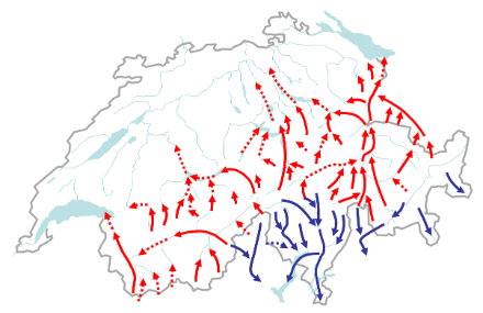
Foehn areas of Switzerland
Foehn occurs most frequently in the north-south or south-north facing Alpine valleys, behind which the mountain passes tend to be lowest. The higher the altitude of the station and the closer it is to the Alpine ridge, the more frequently foehn occurs. As we descend towards the foothills of the Alps to the south and north, the frequency of foehn decreases.
Alpine foehn does not occur everywhere or with the same frequency at all times of the year. The northerly foehn is most active on the southern side of the Alps. The southerly and northerly foehn both occur most commonly in springtime.
The main foehn areas on the north side of the Alps are:
- Lower Valais (foehn via Grand St-Bernard, 2,469 m.a.s.l.) )
- Upper Valais near Visp (foehn via the Simplon Pass, 2,009 m.a.s.l.)
- Haslital (foehn via the Grimsel Pass, 2,164 m.a.s.l.)
- Reuss Valley (foehn via the Gotthard Pass 2,106 m.a.s.l.)
- Glarnerland (Grosstal via the Kisten Pass, 2,640 m.a.s.l. and flowing around the Tödi; Sernftal via Panixerpass, 2,404 m.a.s.l.) ; due to the high "obstacles", foehn occurs somewhat less frequently in Glarus than in the other main foehn areas.
- Rhine Valley (various foehn branches from Graubünden, mainly via the Lukmanier Pass, 1,915 m.a.s.l. and San Bernardino, 2,065 m.a.s.l.).
The main foehn areas on the south side of the Alps are:
- Leventina (foehn via the Gotthard Pass, 2,106 m.a.s.l.)
- Blenio Valley (foehn via the Lukmanier Pass, 1,915 m.a.s.l.)
- Misox (foehn via San Bernardino, 2,065 m.a.s.l.)
- Maggia Valley
- Verzasca Valley
- Riviera
- Magadino Plain
- Valle del Vedeggio (south side of Mt. Ceneri)
- Bregaglia
- Val Poschiavo
- Val Müstair
- Upper Engadine
Long foehn periods
On rare occasions, on both sides of the Alps, the foehn has been known to blow constantly for four to five days. The longest recorded foehn, lasting more than five days, was recorded at the Poschiavo weather station on the southern side of the Alps.
Special forms of foehn winds
Since the foehn is often a very localised d has different effects depending on the region where it occurs, there are certain special variants. The most well-known of these in Switzerland are the gloomy Dimmerfoehn, and the intense Guggifoehn in the Jungfrau region.
Foehn in historic times
For the historic foehn town of Altdorf, we know the frequency of the foehn as far back as 1864. The long data series shows that foehn has always occurred with about the same frequency over the decades.
Foehn theories
Foehn research is already well over 100 years old. One of the central questions has always been how the warm light air can descend into the valleys at all and displace the cold heavy air.