Service Navigation
Search
Annual recurring damage amounting to millions to buildings, cars and agricultural crops impressively demonstrate the effects of severe hailstorms. The most important bases for reliably assessing the hail hazard are measurement methods with high spatial and temporal resolution, as well as long-term data series. The weather radars of MeteoSwiss provide such a data basis for the climatological evaluation of hail occurrence in Switzerland.
The product range consists on the one hand of the new spatial distributions for the mean number of hail days and information on hailstone sizes per year or month, and on the other hand of the maps of the return periods of hailstone sizes. For the creation of the return period maps, a user-oriented statistical resampling method was developed (HailStoRe). Based on the observed hail events, unobserved but climatologically plausible hail events are generated on a probability basis in order to best estimate the probability of occurrence.
For this climate service, the knowledge and needs of project participants from the insurance and construction industries, civil protection and agriculture and forestry flowed together to provide climate information in a user-friendly and application-oriented manner. "Hail Climate Switzerland" is a thematic focus in the National Centre for Climate Services (NCCS).
Hail Climatology
Monthly and annual maps
The occurrence of hail and hailstone sizes are described with the parameters number of hail days (days with hail) and hailstone size. They show the number of hail days for the months of the summer half-year, April to September, as well as the total sum of hail days over the six months.
The hail days are calculated using the POH radar hail algorithm: If the hail probability exceeds a threshold value of 80% on a day at a location for at least 5 minutes, i.e. during a radar measurement step, this day is counted as a hail day. Comparisons with damage data have shown that the 80% threshold value represents the spatial extent of hail as well as the occurrence of hail damage well (Nisi et al. 2016). If hail days are calculated for a larger region such as the whole of Switzerland, a spatial threshold value in square kilometres (e.g. 100 km2) is usually used. If at least this area was affected by hail, the day is counted as a hail day.
Information on hailstone size is calculated on the basis of the radar algorithm MESHS. They show monthly and yearly the largest hailstone size per square kilometre (1 km2) expected by radar.
All monthly and annual maps are calculated for the months of the convective season and are extended on a monthly basis. The annual maps are updated after the end of each convective season.
Maps of the long-term averages
For the parameters hailstone size and number of hail days, the long-term annual and monthly averages per km2 are calculated throughout Switzerland. The maps show how many hail days occur on average each year and how often events with large specific hailstone sizes, for example with diameters from 2 cm, or from 4 cm respectively, are expected.
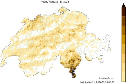
The hail frequency of hail days shows a distinct spatial pattern in Switzerland. Especially in southern Ticino, Emmental, Entlebuch and the Napf region, as well as along the Jura, there are regions where hail is to be expected frequently. In southern Ticino, hail occurs on average up to three times a year in some places. Hail occurs much less frequently in the mountainous regions - often a hail signal was only measured here in individual cases during the entire measurement series. The frequency of hail days is slightly higher in northern Graubünden, where in the past one hail day occurred every 2-3 years.
Due to the rare occurrence of hail, averaging of hailstone sizes over many years is not meaningful. The number of days where maximum hailstone sizes of at least 2 cm (or 4 cm) occur is provided as climatology. These allow for a robust statement about the frequency of events of certain hailstone sizes.
The evaluations take into account all available radar hail data since 2002. The long-term averages can be selected for the entire period (2002 to the present) and for the period of the latest weather radar generation (2013 to the present). In the years 2002 to 2012, which are based on an older radar generation, there are still isolated regions of increased uncertainties in the data, which show up in radar-typical patterns such as wave- or beam-shaped signatures around the La Dôle radar station. These have been almost completely eliminated with the latest measurement technology.
Evolution of hail days
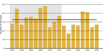
Hail occurs rarely at individual locations, but if Switzerland as a whole is considered, hail days are a very frequent occurrence. Since the start of our measurement series in 2002, an average of 33 days have been counted in each summer half-year (+/- 9 days), on which an area of at least 100 km2 was affected by hail throughout Switzerland.
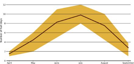
Hail days in Switzerland are most frequent in the summer half-year, from April to September. During the rest of the year, hail days are less frequent. These monthly differences follow an annual cycle, with the maximum number of hail days occurring in the summer months of June, July and August. On average over the period from 2002 to 2020, around 10 hail days occurred in July in Switzerland.

The temporal development of the number of hail days per year shows that there are large fluctuations between the individual years. In addition to the above-average hail years of 2003, 2008, 2009 and 2017/2018, the weather radars recorded very little hail in 2010 and 2014.

| Hail event: | A hail event summarizes the hail occurrence within Switzerland during 24 hours from 6 UTC to 6 UTC. The time period takes into account that a minimum of hail activity is recorded in the early morning hours. This allows the best possible separation of independent hail events. |
| Hail swath: | A hail swath is the trajectory of a single hail cell and its affected area, as detected by the MeteoSwiss thunderstorms radar tracking algorithm. |
| Hail day: | A hail day at a specific location or radar pixel is a day with probability of hail POH ≥ 80 %. If large regions are considered a threshold of the minimum number of radar pixels affected is applied. When considering the entire Swiss territory we apply an area threshold of 100 km2. |
| Hailstone size: | Hailstone size refers to the diameter of a hailstone. In the ideal case, it is measured with a ruler, often size determinations are however determined with the help of reference objects, such as a coin. Computational algorithms are used to determine the hailstone size by means of radar observation (see MESHS). |
| MESHS: | MESHS stands for "Maximum Expected Severe Hail Size" and refers to the maximum expected hailstone size on the ground within a radar pixel of 1 km2 (Treloar 1998 and Joe et al. 2004). |
| POH: | POH stands for "Probability of Hail" and denotes the hail probability with which hail is to be expected on the ground. The value refers to a radar pixel of 1 km2 (Waldvogel et al. 1979 and Foote et al. 2005). |
| LEHA: | LEHA stands for "Largest Expected Hail on a reference Area" and denotes the largest hailstone size to be expected on a smaller area than the square kilometer considered for MESHS. LEHA is a statistical derivation from the hailstone size MESHS. The maximum hailstone size expected for MESHS is expected to occur on only one or few LEHA reference areas withing the MESHS square kilometer. The probability thereof is very small. On the majority of LEHA reference areas LEHA-sizes are to be expected. |
| Footprint: | The footprint is the high-resolution spatial pattern of hailstone sizes MESHS within a single hail swath. |
| Stochastic event set: | A stochastic event set is based on a statistical multiplication of events. The aim of stochastic event sets is to map possible hazards even where no events have yet been observed due to short data series, but where they are plausible from a meteorological-climatological perspective. This makes it possible, for example, to estimate impending damage on a random basis. |
- Bloemendaal N., Haigh I. D., de Moel H., Muis S., Haarsma R. J., J. C. J. H. Aerts (2020). Generation of a global synthetic tropical cyclone hazard dataset using STORM, Scientific Data, 7, 40
- Foote G.A., Krauss T.W. and V. Makitov (2005). Hail metrics using convectional Radar, Proceedings of the 16th Conference on Planned and Inadvertent Weather Modification, San Diego, CA, USA
- Joe P., Burgess D., Potts R., Keenan T., Stumpf G., Treloar A.B.A. (2004). The S2K severe weather detection algorithms and their performance, Weather Forecast., 19, pp. 43-63
- Nisi L., Martius O., Hering A., Kunz M., Germann U. (2016). Spatial and temporal distribution of hailstorms in the Alpine region: a long-term, high resolution, radar-based analysis
Q. J. R. Meteorol. Soc., 142, pp. 1590-1604 - Schwierz, C., Köllner-Heck, P., Zenklusen Mutter, E., Bresch, D. N., Vidale, P.-L., Wild, M., Schär, C. (2010). Modelling European winter wind storm losses in current and future climate, Clim. Change, 101, pp. 485-514, 748
- Treloar A.B.A. (1998). Vertically integrated radar reflectivity as an indicator of hail size in the greater Sydney region of Australia, Proceedings of the 19th Conference on Severe Local Storms, Minneapolis, MN, USA, pp. 48-51
- Waldvogel A., Federer B., P. Grimm (1979). Criteria for the detection of hail cells, J. Appl. Meteorol., 18, pp. 1521-1525

