Service Navigation
Search
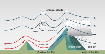
The prerequisite for a northern orographic effect is a dynamic situation with a flow that is almost perpendicular to the Alpine mountain range, combined with a considerable supply of moisture from one or more fronts.
Congestion on the northern slopes of the Alps leads to heavy cloud cover and precipitation.
The most active and precipitation-rich northern orographic effects are either associated with an active warm front or with a cold front associated with subsequent active trough. A succession of warm and cold fronts is also possible. When the air arrives at the Alps in a vertical direction, it is forced to rise. This upward movement expands and cools the air, causing the water vapour in the air to condense. The resulting clouds produce considerable precipitation on the exposed northern slopes of the Alps. The longer the moisture flow lasts, the more precipitation can fall on the northern slopes of the Alps. South of the Alps, the air sinks and dries out, creating a foehn flow. The weather is generally dry and overcast. The southern side of the Alps will therefore remain mostly dry in this situation, with, at most, isolated precipitation from the north.
There are two reasons why the total amount of precipitation varies in altitude according to the direction of inflow: Firstly, depending on the direction of the flow, not all regions of the northern slopes of the Alps are equally affected. Secondly, the direction of the flow determines where the air transported over the Alps comes from. A more westerly flow comes from the Atlantic and will be much wetter than a flow from the polar north. There are therefore three main types of northern orographic effect: Western orographic effect, north-western orographic effect and northern orographic effect
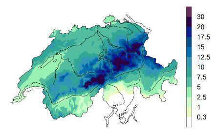
Orographic effect due to westerly flow
The flow often brings very humid and mild air to the Alps when it comes from the west off the Atlantic. The areas particularly exposed to this flow are the Lower Valais, the Chablais and the ridge of the Bernese Alps. The central and eastern foothills of the Alps can also be most affected by precipitation during active westerly weather.
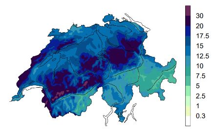
Orographic effect due to north-westerly flow
A north-westerly flow carries moist, cool air all the way to the Alps. Often, such orographic effects lead to the highest precipitation totals, as the flow is almost perpendicular to the Alps. The entire northern slope of the Alps is exposed to heavy precipitation, from the Vaud Alps through the Bernese and Central Alps to Toggenburg.
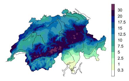
Orographic effects with northerly flow
With an inflow from the north, the air that reaches the Alps is significantly less humid and colder. As a result, the associated precipitation is lower and the orographic effect mainly affects the northern slopes of the Central and Eastern Alps - from the Jungfrau Massif through the Glarus Alps to Toggenburg.