Service Navigation
Search
The Atlantic Ocean determines the climate of Switzerland and of the whole of Central and Northern Europe. Switzerland is located in the westerly wind zone, which is why mild, humid air masses reach Switzerland from westerly directions for most of the year. In a westerly wind situation, moist air flows in a westerly high-altitude current from the Atlantic towards Europe. Within this westerly flow, polar-front waves associated with a low-pressure area pass over Central Europe at intervals of one to two days. Westerly wind conditions can last several days, and sometimes even over a week. They mainly arise from autumn to spring. Weather activity is considerably greater on the north side of the Alps than on the south side.

Changeable westerly winds
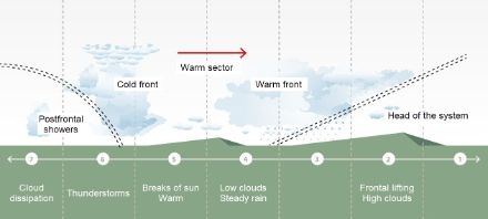
In a westerly wind situation, the passage of a frontal system with warm and cold fronts leads to changeable weather. At first clouds will gather before precipitation sets in with the passage of the warm front. In winter, this can lead to heavy snowfall on the Swiss Plateau. Later, when the warm sector (the zone between the warm front and the cold front) passes through, the clouds will gradually dissipate as they get further away from the low-pressure centre.
A cold front also announces itself with clouds, but the cloud band is significantly narrower than that of a warm front. In summer, thunderclouds usually form on a cold front; in winter, this is the exception rather than the rule. On the back side of a cold front, thunderclouds will form in the cold polar air, especially during the day, and a marked cooling may occur.
Winter storms
In a dynamic westerly flow, low-pressure areas, which form over Northern Europe can sometimes generate strong winds over Switzerland. This is called a winter storm. In such locations, warnings of gale force winds are issued.