Service Navigation
Search
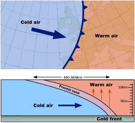
A cold front forms a boundary between warm and cold masses of air when cold air forces the warmer air downwards. As cold air is denser than warm air, it drives the warm air before it and forces it upwards. With the passage of a cold front the wind turns to the right and strengthens (usually from the south-west to the north-west), the air temperature suddenly decreases and the atmospheric pressure begins to rise. On surface weather maps cold fronts are illustrated using a blue line with triangles. They often also show a curve in the pressure field.
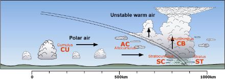
The rising air movements generated by a cold front create clouds that often give rise to rain. The instability will be more or less marked depending on the cold front’s activity and determined notably by the difference in temperature between the leading edge and the rear of the front. Typically, a cold front is made up of nimbostratus, altocumulus and stratocumulus clouds. In cold fronts cumulonimbus are often formed and can produce violent storms, mostly in summer.
Following the passage of a cold front, the weather is characterised by what is known as a “changeable sky” following a brief disappearance of cloud cover (post-frontal clearing). In this changeable period the high-altitude cold air renders the air unstable leading to the formation of cumulus that can cause showers. Thus, dry periods alternate with rain, sleet or snow showers and even hail. These are known as spring showers. When the air is unstable, cumulonimbus (leading to storms) may also form.
Various types of cold front
There are two main types of cold front: katabatic and anabatic cold fronts. A katabatic front is characterised by relatively dry air at high altitude. This prevents clouds from spreading far behind the front and rain therefore occurs on the front or just ahead of it. An anabatic front is composed of moist air that is unstable at high altitude. In this case rainfall occurs mainly behind the front and falls mainly in cold air.
Cold fronts are sometimes followed by a second, less active, front, called a secondary front. These fronts are generally associated with cold polar air. The secondary cold front thus marks the boundary between the cold air (of the first cold front) and the colder polar air.
Some so-called low layer (or surface) cold fronts only bring cold air into relatively lower altitudes. They are therefore less volatile and relatively inactive. The cold air behind the front rapidly stabilises the air mass and stops showers forming.
A masked cold front is the boundary between relatively mild marine air and a colder air mass. The air at low altitude behind a masked cold front is therefore milder than the air above it. This can mainly be observed in winter, as cold air frequently stagnates in the lower layers of the atmosphere while temperatures are higher above, this is called an inversion situation. When a cold front accompanied by relatively mild marine air encounters this cold inversion air, there may be an increase in ground level temperature after the front has passed through.