Service Navigation
Search
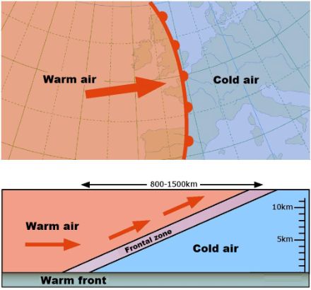
A warm front marks the boundary between cold and warm air masses, whereby the warm air pushes the relatively cool air towards the ground. Since the warm air is lighter than the cold air, it slides over the cold air in front of it and is forced to rise. As a warm front passes over, the wind from the southwest or west freshens and becomes stronger, while the temperature gradually rises and the air pressure falls. Weather maps depicting the weather close to the ground show a warm front as a red line with semicircles.
The upward movement created by the warm front forms clouds that often produce precipitation. Typically, a warm front consists of nimbostratus and altostratus clouds. The arrival of a warm front can be identified by a gradual increase in cloud cover with cirrus and then cirrostratus clouds. When subtropical warm air is unstable, cumulonimbus clouds can also form that can lead to thunderstorms. However, these are less common and less intense than thunderstorms that accompany a cold front.
After a warm front has passed, it quickly becomes dry again, as the incoming milder air at all altitude levels stabilises the air mass. This means that the difference in temperature between the air at ground level and the air at higher altitudes is relatively small, which limits the upward movement of air and, consequently, the formation of showers. It is therefore the opposite of a cold front, where the cold air at higher altitudes behind the front destabilises the air mass.

Special warm front circumstances
In wintertime, warm fronts can sometimes give rise to heavy snow down to the lowlands. This occurs when cold air builds in the lower layers of the atmosphere close to the ground. When the warm front is accompanied by winds that are not strong enough or which are not blowing in the right direction for them to reach the lowlands, the temperatures rise at higher altitudes but remain stable in the lowlands (below 0°C). If the temperatures in the entire air column do not rise above 0°C, then snow falls at all altitudes. This situation is also sometimes referred to as isothermal snowfall. On the other hand, if the temperatures remain below zero at ground level but above zero at higher altitudes, the snowflakes melt in the milder air layers and fall to the ground, where they freeze immediately due to the sub-zero temperatures. This is then referred to as ice rain.