Service Navigation
Search
Wind is defined as the movement of an airmass. It can move horizontally and/or vertically. In meteorology, wind normally relates to the horizontal movement of air. In order to describe (horizontal) wind, two parameters are measured, namely direction and speed. The direction is given either in degrees (1° to 360°) or with the cardinal direction, and indicates where the wind comes from. For example, a westerly wind (270°) blows from west to east. The wind speed is given in kilometres per hour (km/h), in knots (kn) or in Beaufort (Bf).
Wind measurements
The weather stations in the automatic monitoring network operated by MeteoSwiss record the average wind speed and gust speed. The average wind speed is calculated over a 10-minute period. During the 10-minute periods, the maximum gust-speed measured in one second is also recorded.
Hazard warnings

If wind gusts are forecast to exceed 70 km/h in the lowlands or 100 km/h in the mountains, hazard warnings from Level 2 to Level 5 are issued, depending on the intensity of the event.
The impact of wind
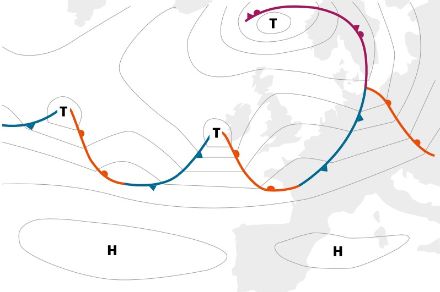
The direction and strength of winds depend primarily on the position of low- and high-pressure areas (synoptic circulation). In Switzerland, wind direction and strength are also heavily influenced by the topography, especially in the Alps. Three main types of wind occur in Switzerland: westerly wind, Bise and Foehn.
Westerly wind is the predominant wind here, appearing the most frequently. It arises in classic westerly wind conditions, with a westerly flow over the Atlantic Ocean between the high-pressure area of the Azores and the low of Iceland. Westerly wind carries mild, humid air from the Atlantic to Switzerland.

Joran and Scirocco
Depending on the position of the high- and low-pressure areas, the wind can turn more towards a northwesterly or northerly direction, in which case, the air will be colder and less humid. If a cold front passes through with a northwesterly flow, the cold air sinks along the southern foothills of the Jura, producing occasionally strong gusts. This northwesterly wind is called a Joran.
On the other hand, the flow may turn in a more southwesterly to southerly direction. In this case, the air is more humid and mild. If the current turns more towards the south, the Scirocco sometimes blows in Ticino. This warm wind is associated with heavy precipitation that builds from the Mediterranean Sea.
Southerly and northerly Foehn
If the flow turns in a southerly direction, this results in a southerly Foehn in the Alpine valleys on the northern side of the Alps. Conversely, the northern Foehn blows in the alpine valleys on the southern side of the Alps when the flow is directed towards the north. Foehn is a warm, dry wind.
Sometimes, the centres of high- and low-pressure areas move away from their usual locations and shift to other regions. When an area of high pressure forms over northern Europe and an area of low pressure forms over the Mediterranean Sea, the prevailing westerly flow is reversed and the wind turns to the east in Switzerland. It is referred as Bise, which is a dry and cold wind, especially in winter.