Service Navigation
Search
Bise occurs when there is an area of high pressure over the northern part of central or northern Europe in addition to an area of low pressure over the Mediterranean. The high-pressure area gives rise to an easterly to northeasterly flow on its southern side, thus affecting Switzerland. This flow is known as the Bise. It also prevents low-pressure systems from the Atlantic from circulating over Central Europe.
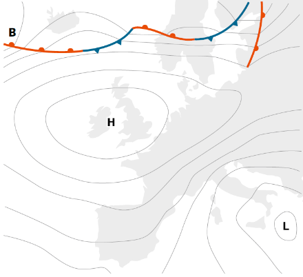
The Bise is mainly experienced in the Swiss plateau and especially in the area of Lake Geneva. The easterly wind is channelled between the Jura and the Alps and picks up speed towards the west as the distance between the two mountain ranges decreases.
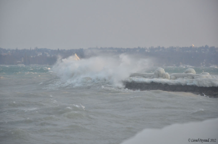
In the western part of Switzerland, a strong Bise can reach storm proportions, especially in conjunction with strong low-pressure activity in the Mediterranean region. One example of such a stormy Bise occurred on 12 November 2004. In the Lake Geneva region, wind speeds of around 90 km/h were recorded, while at the weather stations in Changin and La Dôle, speeds of up to 100.8 km/h and 154.1 km/h, respectively, were measured. This was in contrast to the German-speaking part of Switzerland, where wind gusts barely exceeded 50 km/h.
When the Bise is strong and temperatures are below zero, freezing spray can form on the shores of lakes. The Geneva region is particularly susceptible to such conditions.
Dry in summer; damp and cold in winter
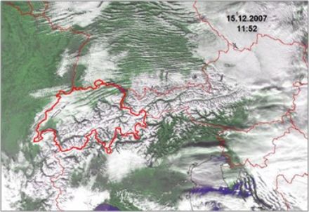
In summer, continental air flowing in from the east is relatively dry. Sunny weather prevails throughout the country, and temperatures are normal for the time of year. In winter, the temperature of the incoming air is often lower, and relative humidity much higher, when Bise is present. The vertical width of this layer of cool or cold air with its high moisture content is between 500 and 2,000 m. Above this layer, warm, dry air can be found, due to the subsidence of the cold air (sinking under the influence of a high-pressure area). These two air masses are separated by an inversion layer, which is thin, but nevertheless distinct. In an inversion layer, the temperature increases with height rather than decreasing, thus preventing vertical air exchange. Inversions occur in high-pressure areas where the air sinks and warms up over a wide area. This causes the air to become dryer and the clouds to dissipate. Underneath, the cold air condenses to fog.
In Bise conditions, the Bise flow causes mixing of the air mass below the inversion. This leads to a higher condensation level and the formation of low stratus clouds. The top of this layer of cloud is at the same height as the bottom of the inversion layer and is related to the strength of the Bise. This means that when the Bise is weak, the top of the cloud layer will be lower than when the Bise is strong. The height of the base of the cloud depends on the moisture content of the air. With a brisk Bise and low humidity, instead of solid cloud cover, broken bands of cloud bands known as cloud streets can form.
Black Bise
Even though the Bise is often associated with dry, stable weather conditions, it can sometimes occur with clouds and rain (or snow). In this case, it is known as the “black Bise”. This occurs when a low near the Alps carries moisture along with an easterly to southeasterly flow.