Service Navigation
Search
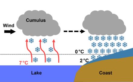
In order to understand the lake effect, the basics of how a shower forms must first be understood. The air must be humid but also unstable, meaning the temperature decreases with altitude. The warm air at the surface of the water (which is lighter than colder air) rises and cools down. The water vapour that is present in the air then condenses, and cumulus clouds form from which rain or snow showers can develop. Although showers can form at any time of year, they are at their heaviest and most frequent between late winter and summer. The layer of air that receives the most heat from the sun is the one closest to the Earth’s surface, so the largest temperature differences are found between that layer and the ones above it.
In autumn and (early) winter, the conditions are not generally conducive to the formation of frequent and intense rain showers, as the temperature differences within the air mass are smaller. However, intense rain showers can form over lakes at that time of year due to the higher temperature of the water compared to the air above it. The air above the water’s surface is warmed, which increases instability and in turn leads to showers. Under certain conditions, there can be more frequent and intense rain showers in lakeland areas.
This is especially the case in early winter when the water temperature is still relatively warm. After a cold front moves in, the temperature at higher altitudes drops considerably, resulting in significant atmospheric instability over the still mild lakes. When driven by the wind, several showers in succession can form, provided there is enough humidity in the air.
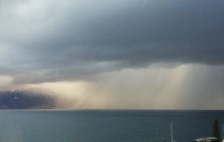
If the air is cold enough, heavy snowfall can also occur along the coastline of the lake.
The term “lake effect” actually originates from the Great Lakes region in North America, where the phenomenon is much more pronounced than in Switzerland (see below).
The lake effect in Switzerland
The lake effect can give rise to showers on any of Switzerland’s lakes, but the probability of it happening decreases with the size of the lake. The lake effect is therefore seen most often on Lake Geneva and Lake Constance.
The extent to which the regions around Lake Geneva are affected depends on the weather conditions. The Vaud Lavaux and the Riviera are affected during westerly winds, while the regions of Villeneuve, Chablais, Bouveret and the French coast are particularly impacted during northwesterly or north winds. On rare occasions, northeasterly wind conditions in the Geneva region can give rise to the lake effect.
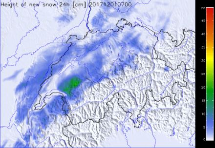
The map below shows the estimated snowfall amount in lake-effect conditions. Over Lake Geneva, existing showers have intensified, resulting in substantial snowfall between Lavaux and the Riviera. With a southwesterly flow, they have extended along the foothills of the Alps towards Gruyère.
By Lake Constance, the region around Rorschach and the St. Gallen Rhine Valley is particularly affected during northwesterly or northerly flows. In the presence of westerly winds, it is the Austrian and German coastal areas that are mainly impacted by the lake effect.
The lake effect in North America
In Switzerland, the lake effect is a phenomenon that is limited both spatially and temporally. However, where larger lakes such as those found in North America are concerned, the lake effect can be much stronger, leading to heavy snowfall. For instance, in the city of Buffalo on Lake Erie in New York State, almost two metres of snow fell within four days in November 2022, with precipitation rates ranging from 7 to 15 centimetres per hour. The Great Lakes not only increase the instability of the air but also serve as a source of moisture. In Switzerland, the lakes are too small to exert any significant influence on the moisture content of the air.
The same phenomenon occurs on the sea, contributing to the intense precipitation found in some parts of the world. This is one of the reasons why Japan experiences heavy snowfall in winter. In rare cases, the Apennines in Italy also have heavy snowfall due to a cold easterly flow over the mild Adriatic Sea.