Service Navigation
Search
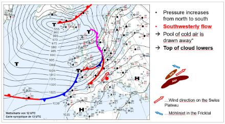
When a high pressure system is located directly over the Alps, or when the pressure distribution is even, the fog-top height varies between 800 and 900 In the event of southwesterly winds (often associated with the dissipation of the high pressure system and a subsequent frontal passage), the fog-top height drops to between 500 and 700 m.
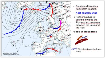
The situation is completely different with a northeasterly "Bise" wind. The stronger the Bise, the higher the fog rises. When a Bise tendency or a weak Bise features in a weather report, the fog-top height is usually in the range of 900 to 1,200 m.a.s.l. With a moderate Bise, the fog-top height rises to 1,500 m.a.s.l., and the fog then penetrates further and further into the Alpine foothills and valleys.
These indications are intended only as rough rules of thumb. For an accurate forecast of the fog-top height and fog dissipation, additional details have to be taken into account. These include the origin of the air masses, the humidity in the different air layers, the change in wind strength and direction, and the strength of the inversion.
Nevertheless, surprises are always possible, and the fog-top can be higher or lower than predicted, so it is worthwhile consulting the latest webcam images from the various providers on the morning of a planned trip.