Service Navigation
Search
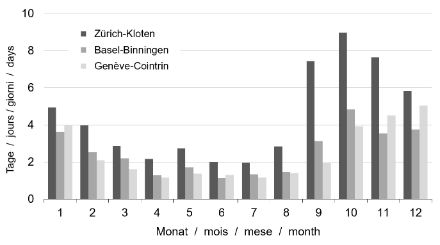
Fog consists of minute water droplets suspended in the air. Because these droplets distribute light evenly, fog appears white or grey. Fog occurs mainly in the cooler months in the low-lying areas on the northern side of the Alps. The weather-station location of Zurich-Kloten is a typical example from the region. Here, the autumn months top the charts when it comes to fog. It is not unusual to see fog every three to four days in October. In more elevated areas and on the south side of the Alps, days with fog are a much rarer occurrence, and are extremely rare in the summer months.
There’s fog and there’s fog
When visibility is less than 1 km, this is referred to as fog. A day with fog is when fog has been present at one of the three daily observation times (morning, noon, evening). Days on which fog dissipates in the early morning, followed by sunshine, are also counted as fog days for statistical purposes. On the other hand, days with low stratus (a layer of fog that does not lie close to the ground) are not usually counted as fog days, as the visibility is often greater than 1 km.
Slight decrease in autumn fog
There is limited availability of long-term observation series with good-quality data on fog. Fog data that have been collected using the same method consistently are available from 1971 onwards. A decrease in the frequency of autumn fog can be identified in the analysis periods from 1971 to 2020 at the Zurich-Kloten, Basel-Binningen, Geneva-Cointrin and Locarno-Monti weather stations. There was a brief increase in occurrences in Basel between 2011 and 2014.
Fewer days with fog overall
During the period from 1971 to 2020, days with fog not only became less common in the autumn but also in the whole fog period from September to February. The mean number of days with fog at Zurich-Kloten, a location renowned for being foggy, was over 50 in the period from 1971 to 1980, whereas between 2010 and 2020, the mean was just 38 days.
The decrease in fog frequency is not only seen for the period from 1971 onwards: A downward trend is also seen in records prior to 1971. Data before and after 1970 cannot be directly compared with one another, since the system was changed after that date.
Why is there less fog nowadays?
Experts cite a variety of possible reasons for the reduction in fog frequency. The MeteoSwiss Technical Report No. 266 highlights the fact that fluctuations in fog frequency generally coincide with the frequency of the weather situations associated with fog. This applies to the annual fog period as well as the long-term fluctuations in the frequency of fog. This suggests that the primary driver of fog’s variability is the weather situation, which creates the main preconditions for fog formation (i.e. high pressure, little westerly flow, cold-air accumulation in Swiss lowland basins, sufficient moisture). The extent to which continuing atmospheric warming affects the frequency of fog-related weather situations has not yet been adequately investigated.
Experts assume that the general improvements in air quality and, in particular, the reductions in sulphur dioxide emissions contributed to the decrease in the occurrence of fog. Sulphur dioxide promotes the condensation of water vapour and hence the development of fog. In addition, soil drainage due to urban development is also thought to be partly responsible. According to this explanation, urban expansion not only causes soils to dry out, but also the air, which impinges on the conditions required for fog formation.
Where does fog most commonly occur?
The regions on the northern side of the Alps where fog occurs most often are as follows:
- The Swiss plateau along the Aare river eastwards from around Biel, with a hotspot in the Aargau wetland area
- The Reuss Valley below Lucerne
- The Wigger, Suhre and Wyne Valleys, the region around the Hallwil and Baldegg Lakes, Freiamt, Limmat and Glatt Valleys
- The region around Lake Constance and along the Thur
These are also the regions that remain fog-bound when the top of the fog layer is as low as 500 to 600 m.a.s.l.
Negative impacts of fog
For many people living in the Swiss lowlands, fog is a considerable nuisance in the winter months, and impacts on their well-being. Fog also has implications for other aspects of daily life. The reduction in visibility is a major issue for traffic both on land and in the air. Many leisure and tourism services benefit if they are in an elevated and therefore less foggy position that has more hours of sunshine than the lowlands. Moreover, fog is closely associated with air-quality issues: In weather situations with fog, air exchange in the lower layers of the atmosphere is severely restricted. This means that pollutants such as fine particulate matter can accumulate and attain concentrations that pose a danger to health.
The development of fog conditions
Low stratus is a typical winter phenomenon that forms in high-pressure weather conditions, particularly when there is a Bise wind. This is when cold air blows into the “bathtub” of the Swiss plateau from the north-east underneath the light, warmer air, where it remains. This creates an inversion situation in which a grey, uniform layer of cloud known as stratus forms, underneath which it is cold and hazy, and above which the air is clear and less cold. Low stratus can also form when ground fog develops during high-pressure conditions after a cold, clear night, and gradually rises.
The top of the fog layer
When a slight pressure gradient from north to south is present in high-pressure conditions, as is typical with a Bise wind, the top of the fog is relatively high (generally above 1,000 meters), because the air builds up at the Alps. If there is no pressure difference, or if there is a gradient from south to north, the height of the fog top sinks to around 600 to 800 metres. The lower the fog top, the greater the likelihood of the fog dissipating during the day.
Inversion
An inversion is a layer of air in which the temperature increases with altitude rather than decreasing, which it would normally. This occurs in areas of high pressure, in which the air sinks over a large area and warms up in the process. As it warms, the air dries out and becomes clear. Conversely, under an inversion, the air cools and reaches saturation, i.e. it cannot hold any more water vapour. This excess water vapour condenses to form a fog cloud, which can cause drizzle or fine snow crystals. This horizontal inversion layer acts as a barrier preventing the exchange of air on the vertical axis. Underneath this layer, pollutants such as soot and fine particulate matter accumulate. The lower the altitude of the layer, the greater the concentration of the pollutants, as they are accumulating in a smaller volume of air.