Contents area

Flow and wave effects – phenomena at fog margins

While a sea of fog may appear static, it is actually in constant flux, as time-lapse photography shows. That is why the top of a band of fog hardly ever stays at the same altitude over the course of a day.

Footer

Top bar Navigation

Swiss federal authorities

Service Navigation

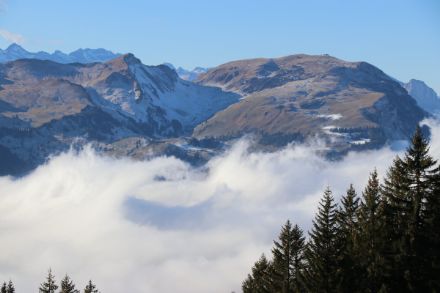
There are various reasons for these movements:

  • When the air warms up during the day, the fog-top height tends to rise somewhat and then sink again at night. This effect is more pronounced in the autumn months than in winter.
  • At the transition zones of the fog, temperature and thus pressure differences arise towards the fog-free regions. This is why the fog is often drawn into the initially fog-free Alpine foothills during the day.
  • Just as in the ocean, a sea of fog is subject to waves passing through it.
  • Changes in pressure distribution, changing wind conditions at the fog top and large-scale uplift effects all strongly influence the movements of the sea of fog.

The images and time-lapse videos below illustrate some of these processes.

Image showing pronounced waves in the sea of fog in the foreground.
When a foehn wind is blowing above a band of low stratus, wave effects can occur. Due to the varying temperatures of the air masses (cold at the bottom, warm at the top) and the large difference in wind speed, so-called Kelvin-Helmholtz waves have formed here. These are comparable to breaking waves on a seashore (view from Hudelschijen towards Stoos and Fronalpstock, 20 November 2018). (© MeteoSwiss)