Service Navigation
Search
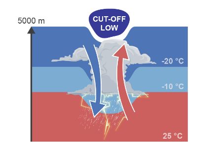
Formation of Cold Air Drops
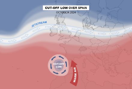
These isolated regions of colder air at higher altitudes are caused by the wave-like motion of the jet stream. When the jet stream dips southward, it forms a low-pressure trough containing colder air. If the wave motion is particularly pronounced, cold polar air can become detached and move southward, leading to the formation of a cold air drop or an upper-level low. This system rotates counterclockwise and is referred to in meteorology as a cut-off low.
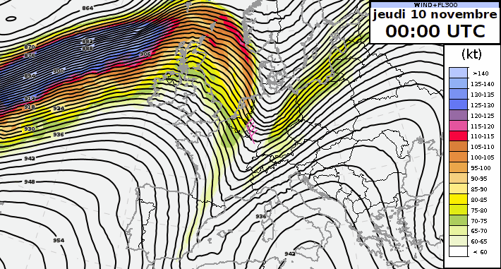
The following animation shows the development of pressure and wind at an altitude of 9 km and illustrates the formation of two cold air drops east of Switzerland. These systems then move westward along the periphery of a high-pressure area.
Impact of cut-off lows
The cold air at high altitude produces instability in the atmosphere. The greater the vertical temperature difference between surface and higher-altitude layers, the greater the instability and the resulting uplift. This uplift can initially lead to the formation of clouds, which then also produce precipitation. In summer, or even in early autumn in the Mediterranean region (as the Mediterranean Sea is still warm), this then leads to thunderstorms.
Cut-off lows are therefore often associated with cloudy weather and precipitation or thunderstorms. In terms of wind, the lack of a pronounced upper-level jet stream and a tight surface pressure gradient mean that strong winds are not a widespread occurrence. However, strong gusts of wind are by all means possible in the vicinity of thunderstorms.
Cut-off lows generally move very little or slowly, as they are isolated or blocked by strong areas of high pressure. They can remain in the same region for several days or even weeks. In these circumstances, the precipitation associated with the cut-off low accumulates in the same location and leads to flooding. One such incident occurred on the Spanish coast in October 2024, when the region of Valencia experienced exceptional flooding (German). Another, older example is the flooding experienced in Switzerland in July 2021 (German), which was caused by a cut-off low lingering north of the Alps.
Greater uncertainty in forecasts
The limited horizontal extension – the largest cut-off lows have a diameter of a few hundred kilometres – mean that these phenomena are generally hard to forecast. The smaller the spatial extension of a weather phenomenon, the harder it is for numerical weather forecast models to map them correctly.
Cut-off lows in forecasts
A cut-off low is defined by a high-altitude pocket of cold air and lower air pressure. In some cases, the upper-level low is strong enough to also generate a surface low, but that is by no means always the case.
It is therefore very difficult to recognise these phenomena on the surface weather map (with plotted isobars and fronts) or in forecast maps. In general, cut-off or upper-level lows are mentioned in the weather reports prepared by our forecasters.
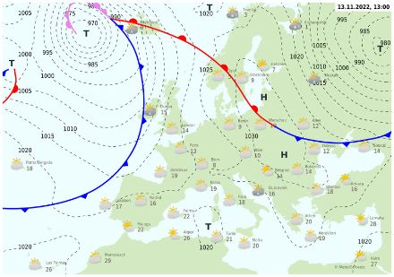
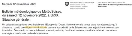
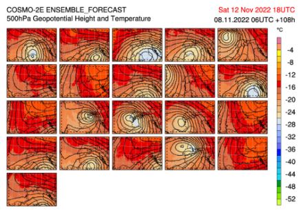
The following example, from 14 November 2022, can be analysed using the surface pressure chart (showing isobars and fronts), as well as the weather report, both of which were available in our mobile app or on our website. If you only consider the surface pressure chart, it is not clear whether the rain forecast in Bern is triggered by the distant cold front. The bulletin, which can always be found above the surface pressure chart (with its isobars and fronts), can reveal this secret: a cut-off low is predicted to pass through on 14 November 2022.
It is therefore clear that the weather will be changeable and rainy on Monday. Moreover, when a cut-off low is present, there is greater uncertainty in the weather forecast. Accordingly, automatic forecasts should be treated with a certain degree of caution.