Service Navigation
Search
In meteorology, the polar vortex is a large low-pressure area located over the North Pole. It is particularly pronounced during the cold season and covers a much larger region than typical low-pressure systems. In Europe, low-pressure systems can have diameters of between 1,000 and 2,000 km. The polar vortex, however, extends from the North Pole to the Arctic Circle and can expand into the mid-latitudes.
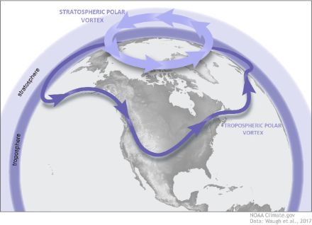
The polar vortex is a structure that mainly develops in the stratosphere at altitudes ranging from 12 to 50 km. The point of origin is situated above the troposphere, the layer in which the major meteorological processes occur. In the polar region, the atmosphere is thinner than it is in the equatorial region, and the stratosphere starts at an altitude of 8 km.
A similar circulatory system exists in the troposphere and can be partially linked with the stratosphere. We therefore make a distinction between the stratospheric and tropospheric vortex. Directly above the North Pole, when viewed from above, a circular, wavy movement of air masses can be observed flowing in a counterclockwise direction. The waves in this flow are known as Rossby waves in meteorology. A similar vortex exists above the South Pole, known as the Antarctic polar vortex.
The stratospheric polar vortex
The counterclockwise rotational movement (which happens clockwise at the South Pole) is caused by the Coriolis force, which is a consequence of the Earth’s rotation. The stratospheric polar vortex forms due to the strong westward flow that is generated in the mid-latitudes at higher altitudes. This flow, in turn, results from the differential warming of the northern and mid-latitudes and the resulting thermal imbalance. This imbalance is more pronounced during the cold season due to the more extreme cooling in the Arctic zones compared to the equatorial zones.
The stratospheric polar vortex becomes stronger and wider in the autumn and weakens in the spring. In the summer, it is completely absent. The polar vortex has a more uniform shape than the tropospheric polar vortex, but certain temporary events can disrupt it, causing it to break apart and disappear for a short period (lasting a few days to a few weeks). This can happen at any time, and not only when the polar vortex is at its weakest. The polar vortex can also be displaced due to the formation of a high-pressure area centred over the pole, which often occurs during the summer months. During the six months of summer, the polar vortex is replaced by the polar summer high, the circulation changes its direction, and the stratospheric winds blow in from the east.
The troposphere polar vortex
The tropospheric polar vortex is also a low-pressure area with its centre over the pole. It is located at an altitude of between 5,000 and 9,000 metres. The polar vortex typically extends to around the 40th or 50th latitude, making it more extensive than the stratospheric polar vortex. The tropospheric polar vortex is also constrained by the western flow of air, but it generally has a less compact structure than the stratospheric polar vortex.
On some days, the tropospheric polar vortex can have multiple centres, but typically the vortex will consist of just one or two centres. In the average boreal winter, there are two centres: one near Baffin Island (Canada) and the other over Northern Siberia.
The tropospheric polar vortex is weaker and less extensive in the summer, but unlike the stratospheric polar vortex, it does not disappear completely. As the polar vortex weakens, it tends to have stronger wave movements. This then leads to sudden changes in weather in the mid-latitudes. Although the tropopause separates the two polar vortexes, they can sometimes interact with each other and influence each other’s behaviour.
Governor of boreal cold
The tropospheric polar vortex interacts with subtropical high-pressure systems located in more southerly latitudes. The Earth’s rotation means that there is no direct exchange of air masses between the equator and the pole at higher altitudes. The jet streams in the mid-latitudes divert the air currents in an attempt to balance the energy imbalance between the equator and the poles. If the Earth did not rotate, a direct exchange between north and south could occur, and the dynamics of the Earth’s atmosphere would be much different.
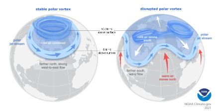
The greater the rotational speed of the polar vortex (i.e. the intensity of the high-altitude winds), the lower the likelihood that tropospheric polar air will intrude into the mid-latitudes (such as into Switzerland). In such cases, the jet stream is straight, with only a few waves. The exchange of energy between the equator and the pole then becomes more difficult, and only a few well-placed disturbances manage to penetrate into the mid-latitudes. Conversely, a weak polar vortex causes a wavy jet stream that promotes energy exchange between the equator and the pole. In this scenario, there is a greater likelihood that a low-pressure area and its fronts will move into the mid-latitudes.
In summary, an intense and well-developed tropospheric polar vortex centred over the pole leads to strong ocean currents and mild westerly winds over Europe. On the other hand, a weak polar vortex leads to greater variability in air currents over Europe, increasing the risk of cold air intrusions or cold waves.
Sudden stratospheric warming
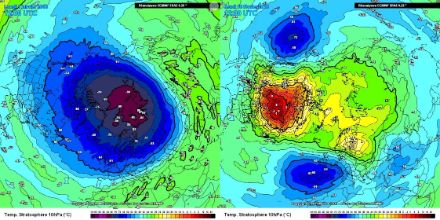
The stratosphere within the polar vortex area can sometimes warm suddenly (up to 50°C within a few days). This is referred to as a sudden stratospheric warming (SSW). Due to its potential impact (cold waves in the mid-latitudes), there is significant meteorological attention on this event. When such warming occurs, a high-pressure area forms in the stratosphere, which can split the polar vortex into several parts and shift it to more southerly latitudes. This displacement of the stratospheric polar vortex can extend into the troposphere, also disrupting and slowing down the prevailing westerly winds. The tropospheric polar vortex located at an altitude of around 5,000 metres can also break down into several separate parts (i.e. low-pressure centres).
The circulation in the troposphere is not necessarily coupled with the stratosphere, as it is possible to have a strong stratospheric polar vortex and a weak westerly flow. Conversely, a warming in the stratosphere does not always affect the troposphere.
Cold air intrusions
A weak polar vortex meanders in a more pronounced way (with larger waves) than a strong polar vortex. This leads to protrusions (troughs) of cold Arctic air that are channelled towards Europe, North America, or Asia. The positioning of these protrusions is somewhat random, and a climatological analysis of their position or frequency is difficult, as a sufficiently long and homogeneous observation record does not yet exist.
The position of these protrusions determines whether or not a cold wave occurs over Europe. For that to happen, the protrusions need to establish themselves between Eastern Europe and Siberia. In the event of a disrupted tropospheric polar vortex and a weak westerly flow, a high-pressure ridge can extend towards the North Sea and the Atlantic. This sets up favourable conditions for an eastern flow that can bring cold air from Siberia to Europe.
The most recent significant event of stratospheric warming that led to a cold-air incursion over Europe occurred in February 2018. In mid-February, there was a marked warming of the stratosphere and a split of the stratospheric polar vortex into two parts – one over Western Europe and another over the North Pacific.
This stratospheric warming spread into the lower atmospheric layers and disrupted the tropospheric polar vortex. It began to meander strongly, resulting in an influx of very cold air into Europe. Siberian cold air reached Western Europe in an easterly flow.
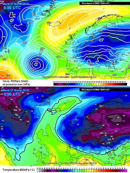
However, this phenomenon does remain limited in time. In 2018, the polar vortex regained strength about 10 days later and brought milder air masses from the west to Europe, thus ending the cold wave. Very cold winters in the past have not always been attributable to a sudden stratospheric warming, as this is both temporally and spatially restricted.
The Antarctic polar vortex
The dynamics of the vortex over the South Pole are similar to those of the Arctic polar vortex, but the flow happens clockwise, as is the case with all low-pressure systems in the Southern Hemisphere. Due to the opposite seasons in the Northern and Southern Hemispheres, it is very rare for both polar vortexes to be present and strong simultaneously. The Antarctic polar vortex (both tropospheric and stratospheric) generally has a more uniform shape. The circulation is more circular and less prone to meandering. This is primarily due to the land masses not extending as far into the mid-latitudes of the Southern Hemisphere, which can influence atmospheric dynamics. The Antarctic polar vortex tends to be less prone to strong disruptions. Sudden stratospheric warmings do exist, but they are still poorly understood, and there are many uncertainties surrounding this topic.