Service Navigation
Search
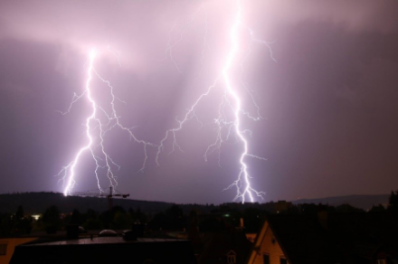
Lightning and the ensuing thunder are the hallmarks of a thunderstorm. They usually occur in summer, when solar radiation leads to the formation of powerful clouds known as cumulonimbus.
How thunderclouds form
Three conditions must be met in order for thunderclouds to form:
- Sufficient moisture for cloud particles to form as a result of condensation
- A potentially unstable stratification of air masses to allow sufficiently powerful air movements (an additional trigger may be needed for instability to occur)
- An uplift mechanism to trigger the formation of the thundercloud
But when and why do cumulonimbus clouds form? The answer lies in the vertical stratification of the air mass. The atmosphere is at its most unstable when very warm, moist air in the lower layers is overlaid with cooler air. This allows the warmer, lighter air to rise upwards due to the Archimedes effect. As it rises, the air cools and condenses, forming the first cloud droplets. If these continue to grow, they are then able to fall to the ground again as rain.
In summer, strong sunlight creates what are known as ‘thermal bubbles’, which rise from the ground, ascend into the atmosphere, and condense to form clouds. If the cloud grows tall enough, then a thunderstorm can develop. Another situation that leads to the formation of cumulonimbus clouds is an influx of colder air, such as when a cold front passes through, displacing and lifting the warm air.
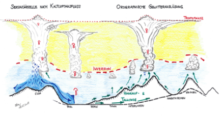
On days with thunderstorms, large amounts of water vapour will often accumulate in the layers of air near the ground. The cumulus clouds forming through convection are normally prevented by a temperature inversion from growing vertically upwards into the middle and upper levels of the troposphere (above 4 km). An additional mechanism is therefore required to supply the energy required for the cloud to overcome this barrier and expand into the upper air layers. In Switzerland, this is usually provided by upslope winds and valley winds in the mountains.
The first stage of thunderstorm development, known as cumulus humilis, is a simple cumulus cloud, the base of which is generally broader than its height. The second stage is cumulus mediocris, the vertical development of which is similar or slightly larger than the width of its base. This gives the cloud a distinctly vertical look. The third stage of development is called cumulus congestus, in which the precipitation begins to form, and weak showers are visible underneath the cloud.
The thunderstorm is born when the first lightning strikes, although to get to that point, not only is condensation needed, but also the phenomenon of icing. The cloud has now reached the cumulonimbus stage, which can take a number of different forms. The most predominant is cumulonimbus calvus, which has a rounded, cauliflower-like top and is typically seen in summer. There is also the better-known anvil cumulonimbus, which is formed by strong updrafts forcing the ice crystals up to the tropopause, where the updraft expands horizontally, sometimes for dozens of kilometres, forming the characteristic anvil shape.
In simplified form, the life cycle of a thunderstorm cell can be divided into three stages: the cumulus or development stage, the mature stage and the dissipation stage.
The role of orography in the formation of thunderstorms
In Switzerland, the uplift mechanism (trigger) required for thunderstorm formation is primarily provided by the mountains. The upslope and downslope winds pump the warmed air up over the mountain, causing a greater accumulation, or convergence, of air over the crests, ridges and peaks. The steadily burgeoning airmass gradually dissolves the inversion, and the thunderstorm clouds start to tower into the sky, which can cause a high electrical voltage to build in the cloud.
Once precipitation processes are already in progress, the spreading cold air often assumes the role of a trigger in a second stage. The cold air spreads horizontally just above the ground and causes the warm air to lift. Due to this additional push, cumulus clouds that were initially shallow succeed in breaking through the inversion and growing into a second thunderstorm cell (secondary cell).
Types of thunderstorm
Thunderstorms can be divided into three main categories, each of which is comprised of several different subgroups. The simplest type is the one described above to illustrate the stages of development, i.e. the single-cell thunderstorm. This is a cumulonimbus with its own internal dynamics, characterised by updrafts that carry warm, moist air upwards. This process can lead to a structured thunderstorm with rain, hail or sleet. Such thunderstorms, also known as heat thunderstorms, typically develop in the late afternoon, mainly over elevated terrain, and occur in the form of isolated, round cells. Their duration is fairly short (30-60 minutes), but they can produce heavy rainfall in a localised area.
The second main group consists of the multi-cell thunderstorms. These are a collection of individual cells that come together to form a more complex structure. They appear on a meteorological radar as a large ‘precipitation field’ with various intensity maxima within the field. Thunderstorms that consist of several interacting cells in this way are less structured but last longer than single-cell thunderstorms. The individual cells can regenerate each other and thus increase the storm’s intensity. They can last several hours and have numerous subtypes that differ in size and shape. For example, the so-called squall line is one type of multi-cell thunderstorm that can occur in Switzerland. It moves very swiftly over areas such as the Swiss plateau or Ticino and leads to heavy rainfall or hail, along with strong gusts.
The third category of thunderstorms is that of supercells, which are the most intense and violent type. They have a clearly defined structure similar to a single-cell thunderstorm, with the difference being that the updraft rotates in a horizontal fashion, thereby creating a self-regenerating system. The updrafts are intensified by the rotation, which makes supercells very long-lasting and violent. They can stretch for hundreds or even thousands of kilometres, and last for several hours. Supercells are the most destructive type of thunderstorm, and often involve large hailstones, severe lightning activity, and very strong gusts. In addition, tornadoes can occur, producing devastating consequences. Tornadoes are very rare in Switzerland, although they have been known to occur, albeit to a lesser extent than in the USA or certain other regions of Europe.
It should also be noted that thunderstorms can also be accompanied by snow. This is the case when the thunderstorm is primarily caused by a pronounced influx of cold air at high altitude. In these circumstances, snow can also fall in lower-lying areas. Snowstorms are seldom seen in the lowlands, although in the higher elevations they can occur in spring and early summer. They are most common in late winter and spring. In the northern Alps, they are more frequent at lower elevations than on the southern side of the Alps, where the phenomenon is extremely rare.
The challenges of thunderstorm forecasting
On days when thunderstorms form, all of the described ingredients and processes vary in intensity depending on the location and time of day, and they influence each other. Correctly evaluating these factors and accurately forecasting thunderstorm development is challenging. Often, it is only possible to make non-specific statements on a regional scale, and only a few hours to a few days in advance.