Service Navigation
Search
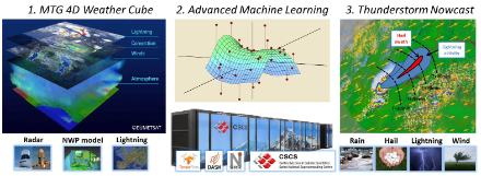
COALITION-4: Context and Scale Oriented Thunderstorm Satellite Predictors Development Version 4
During the warm season, strong thunderstorms regularly occur in the Alpine region. They are often accompanied by hail, heavy rainfall and gale-force gusts of wind. In addition, lightning and flash floods can cause severe damage to properties and infrastructure and lead to life-threatening situations. Accurate storm warnings are therefore essential to reduce damage and protect the population. The development of thunderstorms is determined by dynamic and physical processes ranging from microphysical to synoptic scales. These processes are well understood at a conceptual level, but when it comes to the specific prediction of a thunderstorm, the ability of weather forecasting models is limited for the following reasons: Firstly, the complexity of the microphysical processes goes beyond what can be explicitly represented in an operational weather forecast model due to computational time constraints. Secondly, there are still uncertainties in the simulation of turbulent and microphysical processes. Thirdly, the development of thunderstorms is a non-linear process. It is therefore very sensitive to small uncertainties in the initial state of the atmosphere, which limits its predictability (deterministic chaos). For these reasons, so-called nowcasting methods are used to generate precise, localised thunderstorm warnings with forecast times of a few minutes to a few hours.
Goals and input data sets
To create the COALITION-4 nowcasting products, ground-based radar and lightning data, satellite observations and weather model forecasts are analysed using machine learning (artificial intelligence) methods. These are able to represent multivariate non-linear processes of complex systems and take a large number of predictors into account. Predictors are information on which the prediction is based: The radar data provides information about the hydrometeors (rain, hail, ice crystals, etc.), while the imaging satellite sensors observe the clouds. And the weather model calculates for instance the water vapour content in the atmosphere. With the help of the predictors, the current state of the thunderstorm and the atmospheric environment can be characterised and its further development can be estimated. As there are numerous possible predictors, a selection must be made that incorporates our knowledge of the underlying dynamic and physical processes.
The following milestones have already been reached in this project:
- Preparation for the use of observations from the MTG imager satellite missions for thunderstorm nowcasting by using qualitatively similar observations from GOES ABI and GOES GLM as precursor data for MTG measurements in a development algorithm. The results were published in Leinonen et al, 2021a.
- Development of a deep learning architecture for nowcasting thunderstorm hazards. First, convolutional neural networks were implemented, which are able to analyse spatial structures in the input data (e.g. overhooting tops or hook echos) using convolutional layers. To test our model against other solutions, we took part in the "Weather4cast 2021" competition organised by the Institute of Advanced Research in Artificial Intelligence (IARAI) in collaboration with Nowcasting-SAF. Our model achieved first place in both the Core and Transfer Learning series of competition and in the IEEE Big Data competition. The results were published in Leinonen, 2021b and Leinonen, 2021c.
- Subsequently, the model architecture was extended. Recurrent connections were introduced to better capture the temporal evolution of the thunderstorms. The architecture thus became a recurrent-convolutional neural network (RCNN). Furthermore, it was made possible to analyse more predictors with different spatial resolution. This model was then trained to predict lightning in the short term. The results were published in Leinonen et al, 2022.
- The model was then extended to also predict hail and heavy precipitation. Furthermore, the significance of the different input variables (such as radar, satellite and weather model) for the different target variables (lightning, hail, and heavy precipitation) was analysed. The results were published in Leinonen et al, 2023.
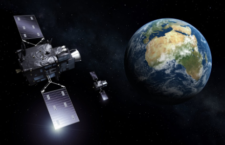
Utilisation of the latest weather satellites
The first satellite of the new generation of European geostationary weather satellites, Meteosat Third Generation Imager 1, was launched into space at the end of 2022. The first pre-operational data deliveries began at the end of 2023. MTG has greatly improved and completely newly developed sensors on board that offer unprecedented opportunities to observe thunderstorms. In COALITION-4, the utilisation of MTG data has already been prepared in previous years:
- The MTG Lightning Imager (LI) measures lightning activity from space. Lightning poses a direct threat to air traffic and outdoor events. Intense lightning activity is also a good predictor of hail formation and severe wind gusts. To quantify the benefits of the MTG LI, similar measurements from the Global Lightning Mapper on the American GOES satellite were used in this project, see Leinonen et al, 2021a.
- The MTG Flexible Combined Imager (FCI) is a follow-up of the SEVIRI instrument on the Meteosat Second Generation (MSG). Significant improvements are expected from the higher spatial, temporal and spectral resolution of FCI compared to SEVIRI. The higher temporal resolution will further improve the tracking of thunderstorms and enable to recognise additional characteristics such as overshooting tops and divergence in the upper cloud area. Additional spectral channels will provide more accurate information on cloud phase, microphysics, and multi-layered clouds. The use of the FCI was prepared with observations from the Advanced Baseline Imager (ABI) on the American GOES satellite, see Leinonen et al, 2021a.
- The Infrared Sounder (IRS) on MTG will measure temperature and humidity profiles that determine atmospheric instability (e.g. CAPE, CIN). The benefit of MTG IRS observations can be mimicked with measurements from hyperspectral sensors (IASI, CrIS and AIRS) on polar satellites.
For further information on the COALITION-4 project, please contact Ulrich Hamann.
- Leinonen, J., U. Hamann, U. Germann, & J. R. Mecikalski, 2021
Nowcasting thunderstorm hazards using machine learning: the impact of data sources on performance
Natural Hazards and Earth System Sciences 22.2 (2022): 577-597; https://nhess.copernicus.org/articles/22/577/2022/ - Leinonen, J., 2021b. Spatiotemporal weather data predictions with shortcut recurrent convolutional networks: A solution for the Weather4cast challenge. Proceedings of the CIKM 2021 Workshops, G. Cong, and M. Ramanath, Eds., URL http://ceur-ws.org/Vol-3052/short15.pdf
- Leinonen, J., 2021c. Improvements to short-term weather prediction with recurrent-convolutional networks. 2021 IEEE International Conference on Big Data, https://doi.org/10.1109/BigData52589.2021.9671869
- Leinonen, J., U. Hamann, U. Germann, & J. R. Mecikalski, 2022
Seamless lightning nowcasting with recurrent-convolutional deep learning
Artificial Intelligence for the Earth Systems https://doi.org/10.1175/AIES-D-22-0043.1 also as preprint here https://arxiv.org/abs/2203.10114 - Leinonen, J., Hamann, U., Sideris, I. V and Germann, U., 2023
Thunderstorm nowcasting with deep learning: a multi-hazard data fusion model.
Geophysical Research Letters, 50, e2022GL101626, https://doi.org/10.1029/2022GL101626 - Rombeek, N., J. Leinonen, and U. Hamann, 2024
Exploiting radar polarimetry for nowcasting thunderstorm hazards using deep learning
Natural Hazards and Earth System Sciences, 24.1 (2024): 133-144. DOI: 10.5194/nhess-24-133-2024