Service Navigation
Search
Context and Scale Oriented Thunderstorm Satellite Predictors Development - Phase 1
(EUMETSAT Fellowship)
During the warm season of the year, intense thunderstorms regularly affect the Alpine region. Such high impact convective phenomena can produce local flash floods causing considerable damages. The need to increase lead time in predicting severe convection is well acknowledged. Numerical weather prediction models provide good forecasts on regional to global scales, but have difficulties in predicting the exact time and location of small-scale phenomena like thunderstorms. Current heuristic methods such as satellite and radar imagery, model output post-processing, satellite nowcasting products, neuronal methods or other statistical methods focus on specific aspects. For example, existing radar-based solutions are well suitable for detecting and extrapolating already existing thunderstorms, when hydrometeors occur. The detection of convective features in early stage still remains a difficult task, especially in complex terrain. Information characterizing the storm environment, in particular retrieved by satellite data, can become very useful for detecting the early stages of a convective process and predict their development.
To this purpose, MeteoSwiss has initiated with the support of EUMETSAT a new research project aimed to develop an object-oriented model with the goal to increase the lead time in predicting severe convective events.
Objectives
The final goal of COALITION is to provide early assessments of potential thunderstorms in terms of severity and location, through the rapid modeling of the available predictors. Thunderstorms are governed by processes which range from the synoptic- to the microphysical scale. COALTION extracts and merges information provided by satellites (Meteosat Second Generation), Weather Radars (swiss radar network), Numerical Weather Prediction (COSMO model), Digital Elevation Models (DEM) and climatological parameters. The orographic forcing is very important in the alpine region, where mountain ridges and valleys affect thunderstorm processes through its whole life-cycle (triggering, reactivation and decaying). The challenge is to build up a methodology aimed to integrate physical and heuristic information into one dedicated model. The output is the probability for a detected object (i.e. a convective cell) to develop into a severe thunderstorm; the output is updated with a frequency of five minutes. This probabilistic product will support end-users (weather forecasters) in the decision process for issuing severe storm warnings.
Data and Methods
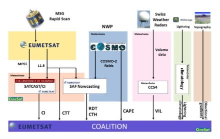
COALITION is a newly developed nowcasting approach to forecast severe convective storms by assimilating data provided by different sources and combining them by means of a conceptual model. The algorithm models severe convection predictors (parameters describing the environment) and evolving thunderstorm attributes as interacting elements.
The most promising parameters characterizing thunderstorm cells provided in realtime by different sources and tools have been included in the model:
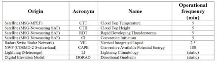
Depending on their context and scale some of the aforementioned data are used to identify objects, which are confined by dedicated rules (e.g. thresholds for cloud top, reflectivity threshold for convective radar cells). In order to describe the environment surrounding the objects that affects its evolution, a few parameters among the available gridded fields have been selected.
The COALITION methodology borrows the approach from the physics of general dynamic systems. The interaction of the environment on the object, e.g. forcing, is modelled as a particle-field interacting system. The dynamics of a particle moving within a potential field is commonly described using Hamilton equations, which are based on the principle of energy conservation.
The results are a probabilistic forecast of intensity evolution of the detected convective cells.
Scientific Results
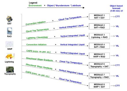
Eight modules, working with data provided by different sources, have been implemented, whereas a further one is being included into the algorithm. Three modules provide an ensemble forecast the evolution of Cloud Top Temperature, the remaining five modules provide an ensemble forecast of the Vertical Integrated Liquid content of thunderstorm cells. All forecasts are calculated in five minute steps for the next hour.
These are the implemented modules:
MOD1: evolution of the Cloud Top Temperature based on the environment defined in terms of the Convection Initiation product (Mecikalski et al 2010).
MOD2: evolution of the Vertical Integrated Liquid based on the environment defined in terms of Cloud Top Temperature.
MOD3: evolution of the Vertical Integrated Liquid based on the environment defined in terms of a lightning climatology.
MOD4: evolution of the Vertical Integrated Liquid based on the environment defined in terms of the Convection Initiation product (Mecikalski et al 2010).
MOD5: evolution of the Vertical Integrated Liquid based on the environment defined in terms of the Convective Available Potential Energy (CAPE).
MOD6: evolution of the Cloud Top Temperature based on the environment defined in terms of orographic information (slope gradients).
MOD7: evolution of the Vertical Integrated Liquid based on the environment defined in terms of orographic information (slope gradients).
MOD8: evolution of the Cloud Top Temperature based on the environment defined in terms of the Convective Available Potential Energy (CAPE).
The case depicted in fig. 3 shows a typical pre-frontal situation over the Swiss Alps. A south westerly flow precedes an approaching cold front and causes some prefrontal convective developments (visible on the infrared image provided by MSG), but, as confirmed by the COALITION and TRT, during the considered period just one convective cell has developed to a severe thunderstorm (see in the center of the images). This situation is usually very favorable for the development of well-structured and long lasting severe thunderstorms, crossing the northern part of Switzerland along the pre-alpine region. Such storms very often produce hail, strong wind gusts and, depending on their velocity and extension, large amounts of rain, increasing the danger of flash floods, especially in the valleys. Sometimes such cells show supercellar features.
The COALITION outputs probabilities in four different classes and colors (fig. 11). For the considered case, at 12:00 UTC COALITION indicates the detected cell to have a probability between 50% and 75% to become severe within the next 15 minutes. This information is confirmed even in the next forecast and therefore can be considered to be robust. As shown in the reference (TRT), the considered storm cell was firstly detected at 12:05 UTC and classified as a weak thunderstorm until 12:20 UTC. During this period, the thunderstorm cell did not show any significant increase of intensity. This is confirmed by the analysis of the surrounding environment included in COALITION: most of the environmental parameters did not show favorable conditions supporting further developments. At 12:25 UTC the cell started an intensification process and at 12:40 was classified as severe.
The analysis of 80 different thunderstorm cells with different intensities demonstrated that for the cases where COALITION provides a probability greater than 25% for more than three consecutive time steps, the probability to increase its intensity and to reach the severe stage is very high.
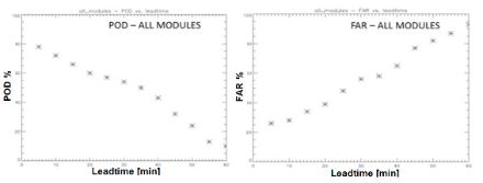
Diagrams in fig. 4 show a first global validation of the algorithm, where the module's results are merged by fuzzy logic system . During the first 20 minutes lead time, the POD decreases from 79% to 60%, whereas the FAR increases from 26% to 39%. These first results could already be considered as useful for automatic nowcasting of heavy thunderstorms. Forecasts for lead times longer than 20 minutes, however the skill decreases often rapidly.
For further information please contact Luca Nisi, Paolo Ambrosetti or Lorenzo Clementi.
- Nisi, L., Ambrosetti, P., & Clementi, L. (2014). Nowcasting severe convection in the Alpine region: The COALITION approach. Quarterly Journal of the Royal Meteorological Society, 140(682), 1684-1699.
- Nisi, L., Ambrosetti P., Clementi L.: 2012, Severe Convection nowcasting in the Alpine region: the COALITION approach, Arbeitsberichte der MeteoSchweiz, 240, 33 pp.
- Nisi, L., Ambrosetti P., Clementi L., 2012: COALITION: Severe Convection Nowcasting in the Alpine region. EUMETSAT Fellowship final report (available on demand: luca.nisi@meteoswiss.ch).
Between May 2009 and June 2012 the EUMETSAT Fellowship project has been presented in several conferences, workshops and seminars:
- EUMETSAT/CIMSS Remote Sensing Seminar (Sasso Di Castalda, 12-18th July 2009)
- 2nd Convection Working Group Workshop (Landshut, 08-10th October 2009)
- EUMETSAT Fellow Day 2009 (Darmstadt, 10th December 2009)
- MeteoSwiss Radar and Satellite Team Science Day 2010-1 (Locarno-Monti, 23th February 2010)
- University of Bern, Institute Applied Physics (IAP) Seminar (Bern, 23th April 2010)
- 10th EMS Annual Meeting (Zürich, 13th - 17th September 2010)
- EUMETSAT Meteorological Satellite Conference 2010 (Cordoba, 20th - 24th September 2010)
- EUMETSAT Fellow Day 2010 (Darmstadt, 8th December 2010)
- MeteoSwiss Radar and Satellite Team Science Day 2011-1 (Locarno-Monti, 22th February 2011)
- National Center of Atmospheric Research (NCAR), short term scientific mission (Boulder 19th Mai - 2nd June 2011)
- EUMETSAT Meteorological Satellite Conference 2011 (Oslo, 5th - 9th September 2011)
- Meeting "Amici della Meteorologia", (Bellinzona, 22th September 2011)
- MeteoSwiss Radar and Satellite Team Meeting (Locarno 30th September 2011)
- COALITION presentation at General Direction of MeteoSwiss (Zürich, 17th October 2011)
- ECSS2011, European Conference on severe Storms (Palma De Mallorca, 3th - 7th October 2011)
- EUMETSAT Fellow Day 2011 (Darmstadt, December 2011)
- University of Bern, Seminar at the Institute of Geography (Bern, 13th March 2012)
- 3rd Convection Working Group Workshop (Prague, 27th-30th March 2012)
- Embry-Riddle Aeronautical University (Arizona) Summer School in Mountain Meteorology (Locarno, 19th June 2012)
- ERAD2012, 7th European Conference on Radar in Meteorology and Hydrology (Toulouse, 25th-29th June 2012)