Service Navigation
Search
COALITION-3: Context and Scale Oriented Thunderstorm Satellite Predictors Development version 3
During the warm season of the year, intense thunderstorms regularly affect the Alpine region. They are often accompanied with hail, heavy rain and gale-force wind gusts. Furthermore, lightning and flash floods could cause severe damages at properties and infrastructure and may lead to live threatening situations. Accurate severe weather warnings are therefore an important mean to mitigate potential damages and to protect the general public. The development of thunderstorms is driven by dynamical and physical processes from microphysical to synoptic scales. The processes are fairly well understood at a conceptual level, but when it comes to the explicit prediction of a thunderstorm cell, the skills of our numerical weather models are limited. Therefore, the strategy of nowcasting is exploited using recent observations to intelligently extrapolate the current state into the near future for severe weather warnings.
Objectives and input datasets
In the recent years, COALITION-3 has been developed at MeteoSwiss that combines conceptual physical models of the evolution of thunderstorms, machine learning techniques, and a large number of predictors such as:
- Observations of MeteoSwiss’ dual-polarisation radar network
- MSG SEVIRI infrared channels and Nowcasting SAF products
- Ground based lightning observations
- Temperature, humidity, and wind observations from COSMO-CH
Methods
The workflow of this nowcasting algorithm is as follows:
- Observations from satellite, radar and lightning detection networks are used to identify and track thunderstorms and describe in detail each individual cell by means of a number of cell parameters (thunderstorm cell biographies) with particular focus on cell severity.
- The observational cell biographies are complemented with data from NWP models which characterize the environment influencing the development of convective storms.
- A machine-learning algorithm is trained on a large number of the cell biographies to find the optimum combination of predictors to make a nowcasts of the evolution of thunderstorms for the next 45 minutes.
The properties of the thunderstorm are monitored along the path of the thunderstorm and the area nearby. To construct the path of the thunderstorm, its motion is derived by an optical flow methods implemented in the open source library pysteps (https://pysteps.github.io/, Pulkkinen et al, 2019).
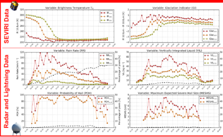
Figure 1 illustrates the history of a thunderstorm showing some satellite and radar parameters along the path of the thunderstorm.
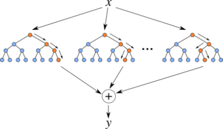
COALITION-3 uses this kind of histories to train a machine-learning algorithm to predict the severity of the thunderstorm. Machine learning techniques have the ability to represent multi-variate non-linear processes of complex systems and are ideally suited to incorporate a large number of predictors and find the optimum combination. The training requires a large number of thunderstorm histories with known thunderstorm development. Hence, we created a training dataset of intense thunderstorms over Switzerland in the convective season of 2018 reaching severities relevant for operational warnings, resulting in total in around 10’000 snapshots of single cells. COALITION-3 applies the extreme gradient boosting algorithm XGBoost (Chen and Guestrin, 2016) to generate the predictions. The algorithm uses a large number of decision trees, each of them performing a series of threshold tests, e.g. is the radar reflectivity is larger than a certain threshold. By randomization of the cases and the predictors, a variety of similar decision trees is generated. Due to this procedure, the results get more robust and accurate.
An illustration of the XGBoost algorithm is shown in Figure 2.
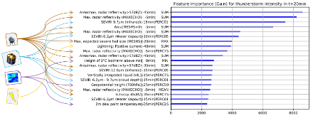
The XGBoost algorithm also has the ability to quantify the importance of the predictors for the thunderstorm severity. The predictor importance varies with forecast time, e.g. Figure 3 illustrates the predictor importance for a forecast time of 20 minutes. In this case, the two most important parameters are the area with a reflectity of at least 57dBZ, and the maximum radar reflectivity 5 minutes ago. The next important parameter is a satellite parameter, the 9.7 micro meter channel of MSG/SEVIRI.
Product Description
COALITION-3 predicts the severity of the thunderstorm expressed as TRT rank for the next 45 minutes and has an update cycle of 5 min. The result covers Switzerland and it’s surrounding, where all input measurements are available. The spatial resolution of the COALITION-3 products is 1 km x 1 km.
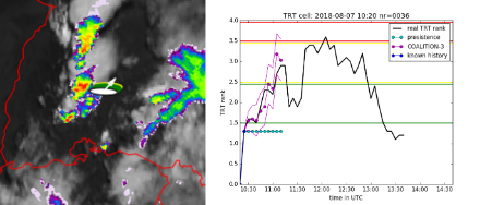
Figure 4 shows an example of a nowcast for a thunderstorm in Baden-Württemberg in Southern Germany at the 7th of August 2018. On the left hand site shows the radar image at 10:25 UTC. The white oval indicates that the current state of the thunderstorm is below the lowest warning level. The white arrow indicates the expected motion of the thunderstorm. The colors shown along the direction of movement indicate the expected severity of the thunderstorm within the next 30 minutes. On the right hand site, the same thunderstorm is shown as a temporal diagram. On the y-axis, the thunderstorm severity expressed as TRT rank is plotted. The thunderstorm warning levels used by MeteoSwiss are indicated as green (moderate thunderstorm), yellow (severe thunderstorm) and red (very severe) region on the y-axis. The black line shows the development of the TRT rank as it was observed on this day. The cyan line illustrate the assumption that the severity is constant. The purple line shows that COALITION-3 prediction of the thunderstorm severity. COALITION-3 correctly captures the intensification of the thunderstorm, including the exceedance of warning levels for moderate (green) and severe (yellow) thunderstorms within the next 30 minutes.
For further information, please contact Ulrich Hamann or Lorenzo Clementi.
Starting 2018 the results of the COALITION-3 project has been presented in different conferences, workshops and seminars:
- EUMETSAT's MTG / EPS-SG User Days, 2019, Darmstadt, Germany
(invited presentation) - 10th European Conference on Severe Storms, 2019, Krakow, Poland
(Best ECSS Poster Jury Award by Shruti Nath et al.) - 3rd European Nowcasting Conference, 2019, Madrid, Spain
- EUMETSAT conference 2018, Tallinn, Estonia
- Leinonen, J., Hamann, U., Germann, U., and Mecikalski, J. R., 2021. Nowcasting thunderstorm hazards using machine learning: the impact of data sources on performance, Nat. Hazards Earth Syst. Sci. 22, 577–597, 2022, doi:10.5194/nhess-22-577-2022