Service Navigation
Search
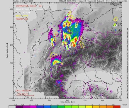
TRT (Thunderstorms Radar Tracking) is an automatic nowcasting tool for the identification, tracking and monitoring of intense thunderstorms. It uses the reflectivity data of the Swiss radar network and provides a real-time information to the forecasters for convection warning.
Thunderstorms in the Alps
In a mountainous region even relatively small but intense thunderstorms can produce local flash floods with severe consequences and damages. Strong convective cells can produce hail and dangerous wind gusts. A reliable prediction of such events must therefore have a high time and space resolution. At present this is only possible using nowcasting tools which combine remote sensing techniques like e.g. radar and satellites. Nowcasting corresponds to very short-range forecast in the time range from 0 to a few hours ahead. For such short-range forecasts numerical models are not yet sufficiently reliable and not updated often enough.
TRT
In this context MeteoSwiss has introduced an automated, radar based tool called TRT (Thunderstorms Radar Tracking), as a part of its thunderstorms nowcasting, warning and information system. TRT performs in real-time an automated detection, tracking and characterization of intense convective precipitation systems. It uses the data of the Swiss radar network (composite image of 3 volumetric C-band Doppler radars) with a time resolution of 5 minutes and a spatial resolution of 2 km.
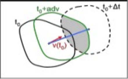
The radar data have already passed sophisticated clutter and quality check algorithms before the ingestion into the TRT-tool. The detection algorithm identifies convective cells in a precipitation system. A cell is defined as a connected zone of radar pixels whose reflectivity exceeds a detection threshold. The tracking of thunderstorms is based on the method of the geographical overlapping of cells (see figure). Trajectories are then created from a sequence of radar images, indicating the movement of the centres of the cells. TRT forecasts storm movement by extrapolating the motion of individual cells up to 1 h, and gives thus a tendency for the expected position.
TRT is developed by MeteoSwiss in collaboration with Météo-France. It is derived from the severe thunderstorms algorithms developed for the RDT product (Rapid Developing Thunderstorms), a tool for the detection of convection in the infrared satellite images.
Operational applications
Nowcasting and monitoring of severe thunderstorms, pre-alert for intense convective systems, decision-making aid for convection warning to civil protection authorities and to the general public.
Publication
Hering, A. M., Morel, C., Galli, G., Sénési, S., Ambrosetti, P., and Boscacci, M., 2004: Nowcasting thunderstorms in the Alpine Region using a radar based adaptive thresholding scheme, Proc. ERAD Conference 2004, Visby, Sweden, 206-211.