Service Navigation
Search
COALITION-2: Context and Scale Oriented Thunderstorm Satellite Predictors Development version 2
During the warm season of the year, intense thunderstorms regularly affect the Alpine region. They are often accompanied with hail, heavy rain and gale-force wind gusts. Furthermore, lightning and flash floods could cause severe damages at properties and infrastructure and may lead to live threatening situations. Numerical weather prediction models provide good forecasts on regional to global scales, but have difficulties in predicting the exact time and location of small-scale phenomena like thunderstorms. Therefore, nowcasting methods are applied using recent observations to intelligently extrapolate the current state into the near future. In contrast to the first version of COALITION, the second version is based on satellite observations only. Hence, it is possible to detect early signs of thunderstorms before the onset of rain. As an independent method, COALITION-2 serves as backup for radar observations, but can also be applied to regions beyond the radar range.
Objectives and input datasets
The overall goal of COALITION-2 is to identify, track and nowcast the position and intensification of convectively active regions in an accurate, continuous and robust manner by exploiting satellite observations. COALITION-2 uses the infrared channels of the MSG/SEVIRI instrument, wind speed and direction as predicted by the weather model COSMO-CH and some products of the Nowcasting SAF software, such as the cloud top height & pressure:
- MSG SEVIRI 3.9 µm channel (rapid scan each 5 min)
- MSG SEVIRI 6.2 µm channel (rapid scan each 5 min)
- MSG SEVIRI 7.3 µm channel (rapid scan each 5 min)
- MSG SEVIRI 8.7 µm channel (rapid scan each 5 min)
- MSG SEVIRI 9.7 µm channel (rapid scan each 5 min)
- MSG SEVIRI 10.8 µm channel (rapid scan each 5 min)
- MSG SEVIRI 12.0 µm channel (rapid scan each 5 min)
- MSG SEVIRI 13.4 µm channel (rapid scan each 5 min)
- COSMO wind (u,v) at 800, 500, 300 hPa (COSMO output every hour)
- Nowcasting SAF Cloud Top Height (rapid scan each 5 min)
- Nowcasting SAF Cloud Top Pressure (rapid scan each 5 min)
- Nowcasting SAF Cloud Type [Optional] (rapid scan each 5 min)
Methods
The SEVIRI instrument onboard of Meteosat Second Generation is sensitive to clouds (and not to precipitation). Therefore, COALITION-2 monitors changes of the cloud properties that are associated with thunderstorms. The algorithm observes how the cloud becomes thicker (increase of the cloud optical depth), how droplet at the upper part of the cloud freeze (cloud top glaciation), and how the cloud top is rising (updraft strength). During daytime one additional tests is performed for small ice crystals (indicating strong convection). For the updraft strength tests, temporal trends of the brightness temperatures are used. These temporal differences are calculated with a correction of the thunderstorms movement using the COSMO wind field as motion vectors. The following table show the threshold tests to monitor the development of the thunderstorm.
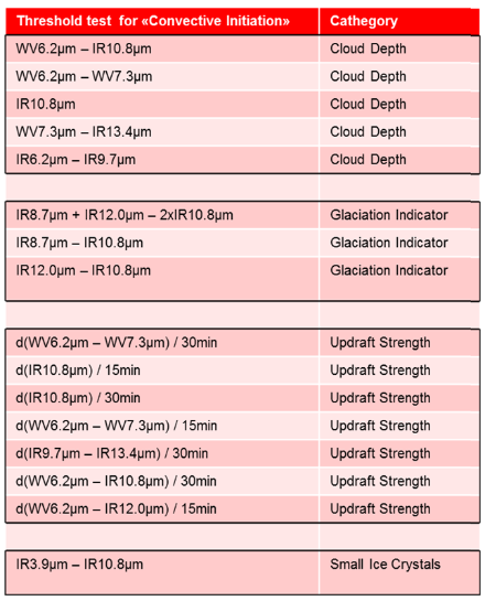
If sufficient tests on the updraft strength and the cloud top glaciation are positive, the thunderstorm is classified as developing thunderstorm. With sufficient positive tests on cloud depth and glaciation, the thunderstorm is classified as mature thunderstorm.
Product Description
Using the information of the cloud optical depth, glaciation and updraft, a false colour image is created, where early convection is shown in green. As soon as cloud top glaciation starts the colour turns into yellow; and mature thunderstorm are depicted in red. During day, the 3.9 µm test is used to locate the most active region of the thunderstorm, shown in purple. (During night, this test is not available, and all the mature clouds are red.) Two COALITION-2 product samples for Switzerland and for Europe are shown in Figure 2 and Figure 3.
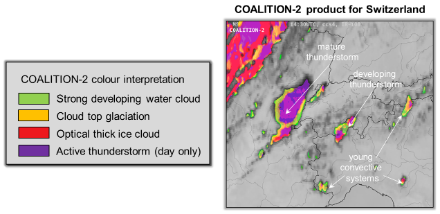
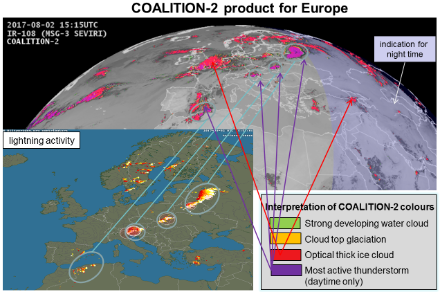
COALITION-2 has an update cycle of 5 min. The Swiss version has a spatial resolution of 1 km x 1 km, the European version has one of 3 km x 5 km. There are small differences in the processing of the different regions. In the Swiss version, the cloud movement is taken into account, improving the product quality, while in the European version this is neglected.
COALITION-2 is particularly useful for the early stages of the thunderstorm. As soon as the thunderstorm is mature, the ambos of the thunderstorm tends to mask the updraft region of the thunderstorm where the strongest hazards are expected. For mature thunderstorms, it is recommended to use COALITION-2 together with the radar product TRT.
For further information please contact Ulrich Hamann or Lorenzo Clementi.
Starting 2014 the results of the COALITION-2 project has been presented in different conferences, workshops and seminars:
- 9th European Conference on Severe Storms 2017, Pula, Croatia
- 2nd European Nowcasting Conference 2017, Offenbach, Germany
- EUMETSAT Conference 2016, Darmstadt, Germany
- CGMS International Cloud Working Group conference 2016, Lille, France
- EUMETSAT's Convection Working Group Workshop 2016, Florence, Italy
- European Conference on Severe Storms 2015, Wiener Neustadt, Austria
- Symposium EGU General Assembly 2015, Vienna, Austria
- EUMETSAT Conference 2014, Geneva, Switzerland