Service Navigation
Search
MeteoSwiss deploys various forecasting models that enable it to calculate the future state of the atmosphere and predict weather developments. The forecasts cover different time scales and sizes of geographical areas.

Nowcasting
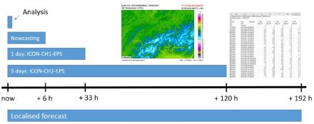
A short-range forecast is produced every 10 minutes with the help of the INCA-CH nowcasting model, which combines all available information in real time. The forecast covers Switzerland and adjacent regions with a grid size of 1 km. The forecasting period ranges from 0 to 6 hours, with data calculated at a temporal resolution of 10 or 60 minutes, depending on the parameter in question. The short-range forecast encompasses a continuous combination of observed and extrapolated data as well as predicted data from the numerical forecast model ICON-CH1-EPS. Long-range forecasts are available for some parameters. These combine the INCA-CH data with the ICON-CH1-EPS forecasts.
Nowcasting is frequently updated. This allows the latest available observations (monitoring stations, radar and satellites) to be taken into account, which improves the forecast quality.
Parameters and data format
The following parameters are currently available:
- 2 m temperature and ground temperature (°C)
- Relative humidity (%) and dew point (°C)
- Mean wind speed and gusts (m/s)
- Precipitation (mm/h), precipitation type (#) and snow proportion of precipitation (mm/h)
- New snow depth (cm)
- Total cloud cover (%), three cloud-cover levels (low, medium, high, in %), relative sunshine duration (%)
- Convective available potential energy (CAPE, analysis only, in J/kg)
- Convective inhibition (CIN, analysis only, in J/kg)
The INCA-CH data are available as grid data (710 x 640 grid points) in netCDF format.
Using the numerical weather forecast models ICON-CH1-EPS and ICON-CH2-EPS, MeteoSwiss offers direct model outputs for the entire Alpine region in the form of hourly analyses or forecasts for up to 8 days ahead. Forecasts for the whole of Switzerland or the entire Alpine region are available for a wide range of parameters.
Several times a day, the models calculate 11 and 21 different forecasts respectively (known as “members”), each with slightly different initial conditions. From this collection of forecasts, the “ensemble”, the probability of a certain weather event occurring can be calculated. The ensemble also provides a measure of the predictability of the expected weather situation and thus also an estimate for the forecast reliability. The data are available from these individual forecasts. In addition, derived values such as quantiles can also be ordered.
|
Forecast period |
Ensemble runs/day |
Member |
Grid size |
|
| ICON-CH1-EPS |
33 h |
8 |
11 |
1.0 km |
| ICON-CH2-EPS |
120 h |
4 |
21 |
2.1 km |
Parameters and data format
The MeteoSwiss forecast data (e.g. for parameters such as temperature, humidity, precipitation, wind, air pressure, geopotential, evaporation and radiation) can be obtained in numerous formats:
- Horizontal fields: Data and graphics for the whole model domain or for a section that covers the whole of Switzerland.
- Tables with all the main weather variables at any number of locations within the model domain. Supplied in CSV format, the data can be integrated into the customer’s own data processing systems.
- Meteograms with graphs of the main parameters for a particular location.
The full list of available parameters is available on request.
The local forecast offered by MeteoSwiss provides a seamless combination of the various advantages of the different products (“seamless forecast”): INCA-CH Nowcasting is used for the first few hours, followed by ICON-CH1-EPS, ICON-CH2-EPS and finally the ensemble model IFS-ENS from the European Centre for Medium-Range Weather Forecasts[interner. These forecasts are identical to the forecasts published on the MeteoSwiss website and in the app.
Further information about local forecasts.
Parameters and data format
In principle, all of the parameters used in the local forecast on the website and in the MeteoSwiss App are available. Supplied in CSV format, the data can be integrated into the customer’s own data processing systems.