Service Navigation
Search
An advanced system has been automatically producing such localised forecasting data for several years, and is responsible for the local forecasts displayed on the MeteoSwiss app and website. The graphics and numeric values are generated by seamlessly combining all available numeric models along with the best post-processing data sources (see the post-processing) and the Nowcasting system.
In order to convert forecasts from weather models operating at different spatial resolutions into a detailed localised forecast, the automatic system uses various sophisticated interpolation and correction techniques to take account of local effects. It also summarises the complex probability information from ensemble models by calculating statistics such as quantiles.
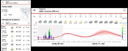
The local forecast data is produced for 6,000 locations in Switzerland and updated every 10 minutes. In total, around 1 billion forecast values are generated every day.
Continuous time series
The first challenge for the automatic system is to produce weather data from the start of the day in question for up to 10 days into the future without interruption, for each of the points for which a forecast is available. In order to cover the entire range of parameters as accurately as possible, we combine the highest-performing forecasting systems available.
The sources used in the production chain are as follows:
- From the start of the day in question for up to 6 hours into the future: the Nowcasting system
- For up to 5 days into the future: MeteoSwiss high-resolution weather models
- Then for up to 10 days into the future: the global ensemble model IFS-ENS from the ECMWF
For certain parameters such as for wind and temperature, forecast data from statistical post-processing is available. Where this adds value and improves the quality of the forecasts, it is also used . The complementary currently used data are:
- MOSMIX, from the German national meteorological service, used for adjusting the temperature data of the weather models close to measurement stations
- Data from our internal post-processing, for forecasts of wind, precipitation and cloud cover variables.
The task of the automatic local forecast system is to combine these different sources in the best possible way to ensure consistency and improve quality.
Local point data
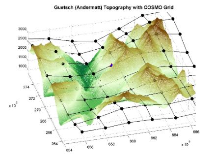
Even high-resolution weather models cannot reproduce the subtleties of spatial structures created by the complex topography of the Alps. In order to forecast local weather conditions as accurately and in as much detail as possible, the results obtained from models with a range of resolutions (between 1 km and 9 km) need to be corrected and harmonised. The use of interpolation and downscaling techniques makes it possible to transform a parameter calculated at the resolution of the model grid to a resolution more appropriate for the user.
The aim is to provide local forecasts that reflect the weather conditions as perceived by a user in a precise location.
Several approaches are deployed, such as the incorporation of very high-resolution (50 m) topographic indices, but also the spatial integration of certain parameters such as cloud cover (since the user can only see the sky as it appears right above their head).
Simple or combined parameters
To meet users’ needs as closely as possible, more than 40 parameters are calculated at each site, and the most important of these are available on the MeteoSwiss app and website. Certain parameters consist of hourly values relating to simple weather variables, such as temperature, wind speed or precipitation, while others represent combined variables in the form of graphics, or even aggregated variables relating to specific time periods ranging from 1 to 24 hours.
Continuously updated data
Since the most recent forecasts are more accurate, the latest updates available from the forecasting models (with an update frequency every 10 minutes for Nowcasting, every 3 or 6 hours for MeteoSwiss’ weather models, and every 12 hours for the global model IFS-ENS) are used. Each time a new update becomes available for a model, the automatic computation chain is triggered and the data is updated.
In this way, a total of around 1 billion forecast values are produced every day.
A statistical and probability-based future
The latest developments have also made it possible to provide new probability-based parameters, such as quantiles or threshold exceedance probabilities. These parameters will enable the range of graphical representations on the website and app to be improved in the near future.
While there will always be an element of uncertainty in the field of meteorological forecasting, one thing is certain: interest in local and personalised forecasts will continue to rise in the future. MeteoSwiss is therefore committed to responding to this growing need by further improving the quality, but also to realistically assess and present reliability.
The next important steps will be to progressively improve forecasts from statistical machine-learning point processing and introduce the new weather model ICON.