Service Navigation
Search
Temperatures decrease with increasing altitude. The altitude above which the temperature drops below 0°C varies depending on the season and weather conditions. The area known as the zero-degree isotherm is the threshold between air layers with temperatures above 0°C at lower altitudes and those with temperatures below freezing at higher altitudes. Among other things, the zero-degree isotherm affects vegetation, the snow fall limit and the water cycle, and so has a considerable impact on the habitats of humans, animals and plants alike. This also explains why the zero-degree isotherm is an integral part of weather forecasts in the Alpine region, and why it plays such an important role in everyday life.
Two different zero-degree isotherms
There are two different zero-degree isotherms. One is determined by means of weather balloons in the free atmosphere, and the other is derived from ground-level measurements at weather stations. In the weather forecasts, the zero-degree level in the free atmosphere is indicated. The zero-degree isotherm near ground level is used to analyse long-term changes, with the help of high-quality historic weather-station datasets dating back many years.
The temperature distribution near ground level, along with the zero-degree isotherm can fluctuate strongly over a very small area, especially in the six winter months. Fog or low stratus layers are an example of this: under the stratus the air is noticeably cold, while above the stratus in the sunshine, the temperatures are pleasant (see inversion). During such weather conditions, the zero-degree isotherm can actually be higher in the mountains than on the fog-covered Swiss Plateau.
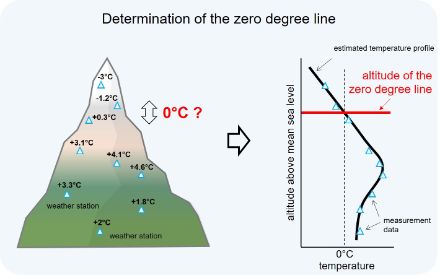
Determination of the zero-degree isotherm near ground level
It is rare for the zero-degree isotherm near ground level to be at exactly the same altitude as a ground-level weather station. On most days, the line is somewhere in between the weather stations. As a result, the zero-degree isotherm near ground level has to be deduced from measurements.
In some cases, datasets from MeteoSwiss ground-level weather stations include daily temperature records dating back to 1864. These enable meteorologists to accurately identify how the height of the zero-degree isotherm near ground level has changed since systematic record-keeping began for larger regions such as northern and southern Switzerland. To this end, the temperatures recorded at all available stations in the area in question on one day are plotted as a function of their station altitude. This produces a temperature profile for each day, from which the daily zero-degree isotherm for a region can be derived. The average of the daily zero-degree isotherm over a full year gives the annual mean of the zero-degree isotherm near ground level.
Significant increases in all months of the year
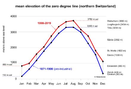
Analyses for the northern side of the Alps show that the altitude of the zero-degree isotherm has significantly increased in all months of the year from 1871 to 2019. The increase is mostly 300-400 metres. Smaller rises of 200 to 250 metres were recorded in April and September, and larger ones in October (around 500 metres), while the largest ones of 600 to 700 metres were in December and January. Between 1871 and 1900, the zero-degree isotherm in winter remained at the altitude of large cities such as Zurich or Geneva, whereas now it is at the altitude of Einsiedeln. Another example that illustrates the increase is that today, the average zero-degree isotherm in March is almost at the altitude it used to be at in April.
The zero-degree isotherm has been rising faster recently
The rise in the zero-degree isotherm has accelerated since 1970, and in some cases significantly. This is especially true in spring and summer, when the zero-degree isotherm has in some cases climbed by more than 100 m per decade. The reason for the rising zero-degree isotherm is human-induced climate change. The current climate mean is already 2.8 °C above the pre-industrial average of 1871-1900 (as of 2024).
Slightly lower increase on the southern side of the Alps
The zero-degree isotherm on the southern side of the Alps is several hundred metres higher than on the northern side of the Alps, especially in winter. However, the increase is somewhat smaller than in the north in most months.
Winters with little snow in the future
According to the CH2025 Swiss climate change scenarios the zero-degree line will rise by a further 200 metres with global warming of 1,5 °C compared to the pre-industrial reference period, slightly above the altitude of Gstaad (1,050 m a.s.l.). In a 3 °C world, it will rise by a further 500 metres, reaching approximately the altitude of Andermatt (1,450 m a.s.l.). The zero-degree line will also rise significantly in summer, accelerating the melting of snow and ice even on the highest Alpine peaks (Less snow and cold).