Service Navigation
Search
Shorter white winters
As the zero degree level rises, precipitation at the beginning and end of winter tends to fall more often as rain rather than snow. Furthermore, a higher zero degree level means that the snow melts more quickly in spring. Winter warming, along with the concomitant rise in the zero degree level, has resulted in the annual number of days with snow cover in the Swiss Alps reducing by between 20 and 30 days, depending on the location.
Winter is arriving later
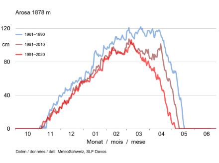
The impact of winter warming on snow cover is very apparent from observations made at the Arosa weather station. Situated at an altitude of 1,800 m in the eastern Alps, Arosa is a classic ski destination. In the winter-sports period from November to April, the total amount of new snow dropped from just under 7 m (1961‒1990 mean) to 6 m (1991‒2020 mean), and the mean snow depth fell from 80 cm to 60 cm. The accumulation of the winter snow cover now takes place half a month later than it used to (Fig. 2). On average, in the period of 1961–1990, the depth of snow cover was around 40 cm by the beginning of December. Nowadays, this depth is generally not attained until the middle of December.
Snow is melting earlier
In Arosa, the maximum snow depth has reduced by 20 percent. It decreased from an average of around 120 cm (1961‒1990) to approximately 100 cm (1991‒2020). Today, the winter snow cover begins to melt on average one month earlier than it did in the comparison period of 1961‒1990. Nowadays, there is an average of 40 cm of snow left around 20th April, whereas in the comparison period of 1961‒1990, Arosa still had an average of around 1 m of snow by the same date.
It is interesting to note that, while there was very little change in the accumulation of snow cover between the two comparison periods of 1981‒2010 and 1991‒2020, the snow melt has been starting noticeably earlier in the last 30 years.
Less snow
The delayed accumulation of snow cover and the earlier snow melt have a considerable impact on the duration of snow-cover periods.
In earlier times, we could expect the average depth of snow cover to be at least 40 cm from the beginning of December to 10th May. Today, the 40-cm minimum snow depth in Arosa is only seen from the middle of December to 20th April, on average. The period with at least 40 cm of snow cover has therefore shortened from just under five and a half months to just over four months.
Snow cover of at least 80 cm used to be present in Arosa from the middle of January until the end of April, on average. Now, however, this snow depth is only found in Arosa from the end of January to the end of March. This is a reduction from three and a half months down to two.
Mountain peaks less affected
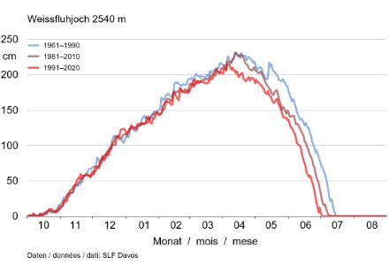
Winter warming and the consequent rise in the zero degree level has had a much smaller impact on the formation and melting of the snow cover at higher altitudes (Fig. 3). At the Weissfluhjoch weather station, slightly north of Arosa at 2,540 m above sea level, there has been no discernible change in the accumulation of the snow cover over the past 60 years. There was an insignificant reduction in the maximum snow depth from an average of 2.25 m (1961‒1990 mean) to an average of 2.1 m (1991‒2020 mean).
The melting of the winter snow cover on the Weissfluhjoch starts on average today around 10 days earlier than it did in the comparison period of 1961‒1990, which then has a noticeable impact on snow depth: Nowadays, in mid-June, the average snow depth on the Weissfluhjoch is 80 cm, whereas in the comparison period of 1961‒1990, it was 130 cm. Today, the winter snow cover disappears on the Weissfluhjoch by around the end of June, while during the comparison period of 1961‒1990, there was still almost 1 m of snow on average by that point in time.