Service Navigation
Search
An occlusion, or occluded front, marks the border between two polar air masses of differing temperatures. It arises when a cold front is moving faster than the warm front ahead of it and eventually catches up with it. As the cold and warm fronts converge, the warm sector becomes smaller, and the warm air mass is lifted by the cold front. The merging of the two fronts creates an occluded front.
The cloudiness associated with an occlusion is a mixture of warm- and cold-front clouds. Thunderstorms can also occur.
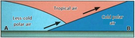
Two types of occlusion
There are two types of occlusion, which differ in terms of their weather characteristics. The cold front occlusion has the weather characteristics of a cold front, while the warm front occlusion has more of a warm-front character.
When the polar air mass of the cold front is colder than the polar air mass ahead of the warm front, this is a cold-front occlusion. The colder polar air is denser and therefore heavier, forcing the air masses ahead of it to rise.
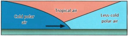
The situation is vice-versa for a warm-front occlusion. The air mass of the polar cold front is colder than the polar air mass that is in front of the warm front. This means that the polar air mass of the cold front slides over the cold polar air mass and forces the warm, tropical air to rise.