Service Navigation
Search
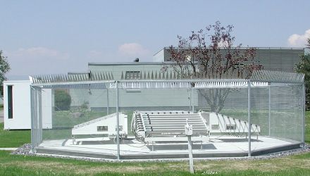
The windprofiler measures the radial velocities of turbulent structures, which travel with the wind, along the five antenna beams. The radial velocity is derived from the frequency difference in the emitted and the received electromagnetic wave according to the Doppler effect. The horizontal and vertical wind components are then derived from the five radial velocities.
Interpretation of windprofiler data
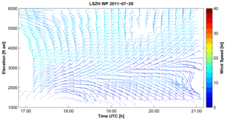
The windprofiler provides a wind profile every 10 minutes covering an altitude range from 150 to approximately 5000 m above ground. The maximum reached altitude depends on the atmospheric conditions. The windprofiler measurement provides wind speed and direction as a function of altitude and time. The windprofiler provides also information on the height of the planetary boundary layer and the height of the transition between snow and rainfall.
Weather prediction and surveillance of the nuclear power plants
MeteoSwiss operates a windprofiler at Payerne since 1994 for the continuous measurement of the wind conditions above Payerne. Since 2008, MeteoSwiss operates a network of three windprofilers which are located in Payerne, Grenchen and Schaffhausen. The wind data are used to drive the numerical weather prediction (NWP) model. In the frame of EMER-Met (Emergency-Response Meteorology) the combined system of windprofiler and NWP model is used for the meteorological surveillance of the nuclear power plants. The latest measurements of the Swiss windprofiler network can be accessed here.
The European Network
The Swiss windprofiler network is part of a European network called E-PROFILE which counts over 30 windprofiler stations. All these windprofilers are used to drive NWP models on different scales by different institutions. The European Centre for Medium-Range Weather Forecasts (ECMWF) uses these data to calculate the global forecasts that are used by MeteoSwiss to drive the regional weather model ICON.