Service Navigation
Search
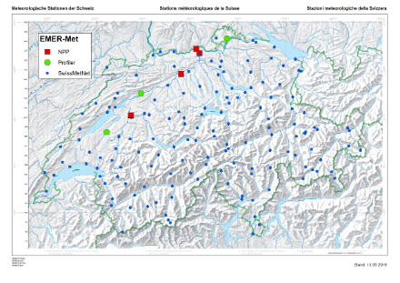
In close cooperation with the Federal Nuclear Safety Inspectorate (ENSI), MeteoSwiss has developed the EMER-Met (Emergency Response Meteorology) wind analysis and forecasting system, which began operating at the end of 2009. In 2019, the Federal Office for Civil Protection (FOCP) joined as an additional partner. MeteoSwiss is currently updating the system to the latest state of the art. The system includes a large number of special measuring instruments and the ICON-CH1-EPS weather forecast model. The combination of precise measurements and high-resolution model forecasts makes it possible to determine wind fields and weather developments around Switzerland’s nuclear power stations and those in neighbouring countries and thus to calculate the dispersion of contaminated air masses. Both the ENSI and the National Emergency Operations Centre (NAZ) of the FOCP use the information to assess situations in real time. On this basis, the NAZ is able to take measures to protect the population.
Special measuring instruments
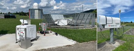
MeteoSwiss has set up its own monitoring network for EMER-Met, which was recently updated. It records the atmosphere above the Swiss plateau in detail, in particular in the direct vicinity of the Swiss nuclear power stations. It comprises three different monitoring systems:
- At the sites in Schaffhausen, Payerne and Grenchen, remote sensing instruments – wind profilers, radiometers and wind lidars – continually measure the wind, temperature and humidity from the ground up to several kilometres. The wind profiler is a radar that derives a vertical profile of wind speed and wind direction for all altitudes up to 8 km above ground from the reflections of the radar beam off air turbulence. The wind lidar is based on the same measuring principle, but uses an eye-safe laser beam instead of a radar beam and measures the wind up to 2 km above ground with higher accuracy. The microwave radiometers derive the humidity and temperature from the intensity of the atmosphere’s natural microwave radiation.
- High telecommunications towers reaching 100 to 250 metres above the ground and equipped with meteorological measuring devices are situated on the peaks of the Uetliberg, St. Chrischona, and Bantiger.
- At the nuclear power station sites, MeteoSwiss also measures turbulence in addition to the usual SwissMetNet parameters.
This special monitoring network is supplemented by the SwissMetNet ground-level monitoring network of MeteoSwiss, which comprehensively records the meteorological parameters close to ground level.
Dispersion calculations with the ICON-CH1-EPS forecasting model
The measurements taken by the three wind profilers and SwissMetNet are fed into the ICON-CH1-EPS local weather forecasting model of MeteoSwiss, which was developed to be used in the event of nuclear accidents and for other purposes. On a grid network with a horizontal grid box size of 1 km, the model calculates the weather developments for the coming 33 hours in the Alpine region every three hours (and for 45 hours at the 03:00 UTC forecast).
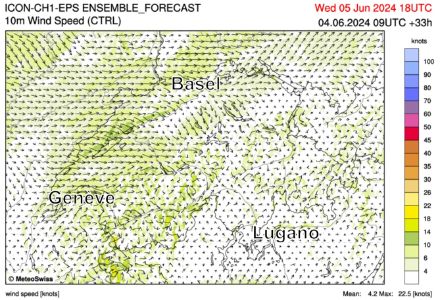
The high-resolution wind and precipitation fields of ICON-CH1-EPS enable the forecasting of the dispersion of contaminated air masses as well as the washing out and deposition of radioactive substances. MeteoSwiss provides delay-free forecasts for wind and precipitation as well as other meteorological parameters to the Federal Nuclear Safety Inspectorate (ENSI) and dispersion calculations to the National Emergency Operations Centre (NAZ). In parallel to this and working on the basis of the relevant measurements and dispersion calculations, the MeteoSwiss meteorologists are responsible for providing both institutions with advice regarding the current weather situation and further meteorological developments in the event of a nuclear accident.
NADAM: Automatic Dose Alarm and Monitoring Network
In addition to the EMER-Met system, MeteoSwiss also operates the NADAM monitoring network on behalf of the National Emergency Operations Centre (NAZ). More than 60 automatic weather stations are equipped with special probes which measure the level of radioactive radiation (local dose rate). Together with the precipitation data, the local snow depths and other meteorological parameters, MeteoSwiss transmits the data to the NAZ every ten minutes. If a specific threshold is exceeded (1 micro-Sv/h), an automatic alarm is triggered at the NAZ.