Service Navigation
Search
Water temperature matters for a wide variety of activities, including swimming and all kinds of other water sports, as well as fishing. The temperature of the water also has a significant impact on the currents in a lake, which in turn affect biological processes as well as water quality.
Measurement methods
Hydrologists use a number of different methods to measure and study the water temperatures and currents in lakes. One way they do so is by taking spot readings, both at the surface (as at Station Buchillon) and in the deeper layers of water using special submersion probes. Satellite data is also used to obtain information about surface temperatures.
However, these measurement methods are not sufficient on their own to allow the researchers to form a comprehensive, three-dimensional picture of the water temperatures. For this, hydrologists use numerical models – similar to those used by meteorologists and climatologists – which simulate the water circulation and temperatures in rivers and lakes with the help of observations and physical comparisons of fluid dynamics.
One of these models can be accessed via the Meteolakes platform. Developed by a scientist at ETH Lausanne, it provides temperature and flow observations and forecasts for several Swiss lakes. The graphic representations allow the relevant lake surface to be depicted with water temperatures (for the uppermost 60 cm) and surface currents simultaneously, as shown in the following animation.
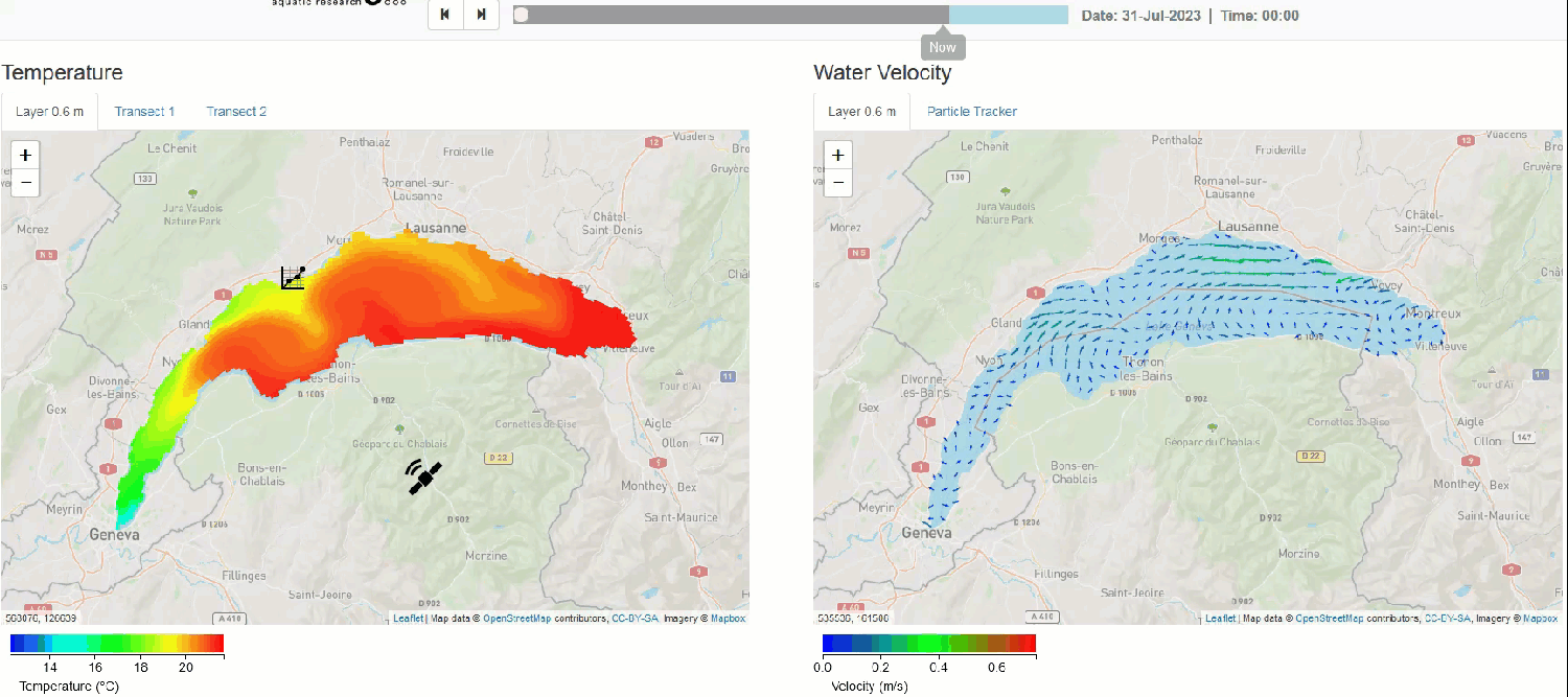
Abrupt cooling in August 2023 - Lake Geneva
From the animation, we can clearly see how cold the western part of Lake Geneva must have felt to swimmers at the beginning of August 2023. The water, which was already quite cool for the time of year at the end of July, cooled down even further.
We can consider a couple of different explanations for this:
- Sustained precipitation, resulting in a direct influx of cold water from the atmosphere.
- Heavy rainfall in the mountains, resulting in additional cold-water influx from the rivers.
However, neither of these were the case in western Switzerland at the time. There is a third plausible hypothesis,
- which is that cold water from the lower layers of the lake must have risen towards the surface in a process known as “upwelling”.
Upwelling – a peek into the depths
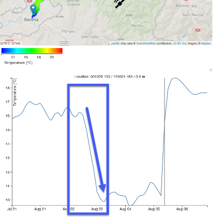
To test our upwelling hypothesis, let’s take a look at the modelling data with the help of a cross section of the lake from Geneva to Villeneuve. The timeframe is exactly the same as that of the animation above.
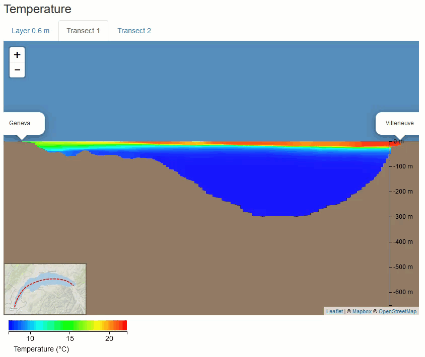
The water in the surface layer is much warmer than the deep water – which is to be expected. We can also see that the western part of Lake Geneva on the left-hand side of the cross section (known as “Petit Lac”) is cooler than the rest of the lake right at the start of the animation but cools down even further throughout the course of the day as the cold water from the depths rises to the surface. Our assumption that the cold bathing conditions were due to upwelling is therefore confirmed by the modelling animation.
But what was it that triggered these large volumes of cold water to rise in the middle of summer? And why is the upwelling seen only in the western part of Lake Geneva in particular?
The explanation is found by turning once again from hydrology to meteorology.
Wind is the driving force behind upwelling
The blame for the water in “Petit Lac” cooling down lay squarely with a chilly southwesterly wind: When wind blows over a lake, it causes friction, pushing the surface water in the same direction.
At the end of July and into early August, westerly and southwesterly wind patterns were prevalent, with winds blowing more often and more forcefully than is usual for the season. Let’s take a look at the measurements from our station at Geneva-Cointrin Airport during the timeframe of this significant drop in temperature:
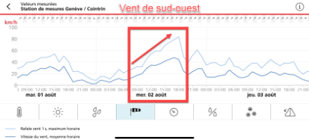
Throughout the entire period, the wind was blowing from the southwest, but on the afternoon of 2 August, it became much stronger, reaching average speeds of over 40 km/h and gusts of nearly 80 km/h.
As the strength of the wind intensified, the movement of surface water towards Lausanne also increased, pushing the colder, deep water in the western part of Lake Geneva closer to the surface. This led to the abrupt cooling of the water.
When strong winds blow across a lake (as with westerly wind patterns, Bise, foehn winds, etc.), we can use wind speed and wind direction forecasts to estimate where and when the upwelling phenomenon and thus the cooling of the water might occur.
Another significant temperature drop in Lake Constance’s Untersee
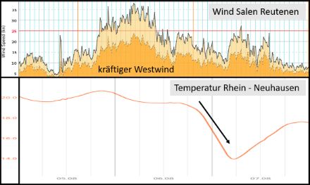
The same phenomenon observed in Lake Geneva was also observed in Lake Constance at the same time. On Sunday, 6 August 2023, strong west to southwest winds blew all day at the southern edge of a storm low. These winds “pushed” the surface water eastwards from the section of Lake Constance known as the “Untersee”. In the evening and during the night, cooler water from the deeper layers of the lake then flowed in, causing the temperature to drop from just under 20 degrees to below 15 degrees in a short period and for a short while. This process is clearly illustrated by the graph based on data from Salen-Reutenen (wind on Lake Constance) and the water temperature of the Rhine at Neuhausen.