Service Navigation
Search
Aircraft must always be separated by a certain distance to avoid mid-air collisions as they fly. Safe vertical separation is ensured by the use of so-called flight levels. This entails flying at predefined flight levels that are set according to an international standard. This ensures that the aircraft fly at different altitudes in order to avoid mid-air collisions. Meteorological conditions influence the true height of the flight levels above sea level, with consequences for their use. For this reason, MeteoSwiss regularly provides air traffic control with the true altitudes of the flight levels.
Air pressure and altimeters
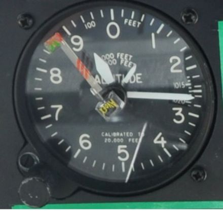
To navigate when flying and to ascertain their flight level, pilots use altimeters. These instruments gauge the atmospheric pressure using pressure sensors mounted on the side of the aircraft, then convert this information mechanically to provide the flight altitude of the aircraft.
Standard atmosphere with reference to aviation
All pilots, whether of hot air balloons, gliders, hang gliders or commercial aircraft, use the same references in flight. To avoid collisions, it is essential that they all use the same settings for their altimeters. With this in mind, an internationally applicable standard atmosphere has been defined, called the International Standard Atmosphere (ISA). The following reference values apply to the ISA:
- A reference pressure at sea level of 1,013.25 hPa;
- A pressure decrease with increasing altitude per hPa of 28 ft corresponding to 8.5 m per 1 hPa (1 ft = 0.3 m).
Pressure fluctuations at ground level
In reality, the pressure field on the ground and at altitude very much depends on the current meteorological conditions. Low-pressure areas tend to be associated with low air pressure (below 1013.25 hPa), while high-pressure areas tend to have high air pressure (above 1013.25 hPa). The air pressure can fluctuate widely along the flight path of a commercial aircraft, which usually extends over hundreds or even thousands of kilometres. Pilots therefore use a common reference pressure to ensure their vertical separation during cruise flight. Otherwise, the values displayed by their altimeters would not be comparable: Two aircraft with different pressure settings might fly much closer together on a vertical plane than the readings from their altimeters would suggest.
The flight levels
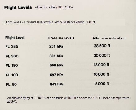
In order to separate air traffic and prevent collisions, aircraft in cruise flight fly at common pressure levels known as flight levels (abbreviated to FL). The flight levels correspond to the altitude in 100-ft increments (hectofeet) above the pressure surface of 1,013.25 hPa calculated according to the standard atmosphere. For example, FL050 is the pressure surface 5,000 ft above the pressure surface 1,013.25 hPa. The flight levels are all based on the altimeter setting of 1,013.25 hPa.
This default setting is applied above a certain transition altitude, which is set above the terrain elevation. Above this altitude, the aircraft do not fly at a constant height above the ground, but along the corresponding flight levels, which have a constant pressure.
The influence of weather conditions on the flight levels
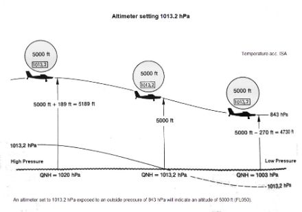
Just as the pressure at ground level varies greatly over time and from region to region, so does the true altitude of the 1,013.25 hPa pressure surface, and hence the flight levels.
• High pressure: The pressure surface of 1,013.25 hPa is higher than in the normal atmosphere and so the flight level increases.
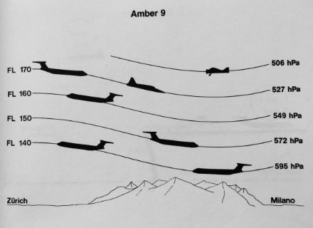
• Low pressure: The pressure surface of 1,013.25 hPa is lower than in the standard atmosphere and so the flight levels are lowered. Particular care is required when crossing mountains at very low air pressure, as the flight levels can then drop below safe altitudes. Some flight levels can therefore no longer be used in such situations, as they come too close to, or even coincide with, the terrain!
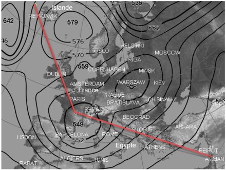
Example
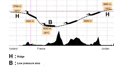
In this example, there is an area of high pressure over the British Isles and an area of low pressure over northern Italy. An aircraft flying, for example, from Reykjavik via France to Jordan would thus be exposed to correspondingly large pressure fluctuations. At the same altitude of, say, FL180 (18,000 ft above the pressure surface 1,013.25), however, the aircraft’s true altitude fluctuates while the altimeter reading remains constant.
Summary
So that the altitude measured by the altimeters during cruise flight show the same values in all aircraft and thus ensure vertical separation between them, pilots must set their altimeters as if the pressure at sea level were a constant 1,013.25 hPa.
Although flying with this reference setting ensures the vertical separation of the aircraft, the actual altitude off the ground varies. This is determined during take-off and landing below a specified transition altitude by adjusting the altimeter to the current air pressure of the airport (abbreviated as QNH). (Definition of this term on page about air pressure)
Flying at high altitudes above the ground in cruise flight does not require significant altitude accuracy, so pilots fly with the default setting of 1,013.25 hPa (QNE).
During the initial climb or approach phase, when the altitude is closer to the ground, the altimeters are set to the QNH of the airfield where they intend to take off or land. The switch between QNH and QNE occurs at a fixed transition altitude that maintains a minimum distance from the terrain. If the flight level during cruise flight is below the transition altitude, then QNH is used for the altimeter setting in cruise flight, and the altimeter is adjusted at each sector change.
Flight levels and MeteoSwiss
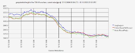
MeteoSwiss calculates the true altitudes of FL100 and FL180 in Geneva and FL140 in Zurich every three hours on the basis of measurements from the Jungfraujoch and Gütsch weather stations, and radiosondes from Payerne and Novara. The values are used by Skyguide’s air traffic controllers to determine which flight levels can be used for Alpine crossings and which are too low.
The graph below shows the development of the 700-hPa geopotential surface measured at three weather stations from 12 to 13 October 2020. We see here that the height of the geopotential surface has decreased considerably (by approximately 50 metres) as a result of a broadening of the low-pressure axis aloft. As a result of this change in atmospheric conditions, the flight levels decrease.