Service Navigation
Search
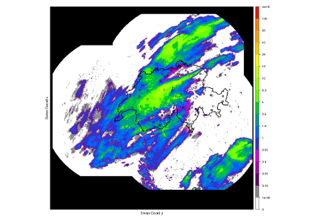
The CombiPrecip (CPC) product delivers information on hourly precipitation levels at ground level. Using a geostatistical method, radar estimates are combined with data from land-based weather stations. The CombiPrecip products cover the entire area monitored by the Swiss weather radar network, which includes Switzerland and its neighbouring regions.
CombiPrecip is particularly suitable for applications that require precipitation estimates in a high temporal and spatial resolution, such as in the field of civil protection, for flood warnings or for interventions during flooding events. The hourly CombiPrecip product has been available since 2005, and the archived data series are useful for activities in areas such as flood prevention, hydroelectric power management, agriculture, tourism and numerous fields of research.
|
Parameters |
Precipitation amounts at ground level (hourly or every few hours) in mm (l/m2) |
|
Frequency of data delivery |
Every 10 minutes/hourly/daily |
|
Spatial resolution |
Radar system with 1 km2 spatial resolution, combined with the rain-gauge stations in Switzerland. |
|
Data availability/ |
From 1 January 2005 |
|
Coordinates system |
Swiss land coordinates |
|
Data quality |
The accuracy of CombiPrecip is heavily dependent on the quality of the input data – in other words, the precipitation measurements taken at the land-based stations, along with the radar estimates. Between 2010 and 2016, the Swiss radar network was upgraded and expanded from three to five stations. In addition, the number of rain-gauge stations also rose significantly, from the 71 that were in operation between 2005 and 2010, to the over 200 stations that have been in operation since 2015. These changes have had a positive impact on the quality of the product, which should be taken into consideration when interpreting the data. A further factor that influences the quality of the product is the weather situation: Precipitation that is present in layered clouds over a large area is the ideal situation, as the measurements can then be captured by large numbers of rain gauges at ground level, thereby improving the algorithm. CombiPrecip has an integrated quality index which provides information on the quality of the data. |
|
Formats |
GIF (all of Switzerland only) NetCDF, ASCII, GeoTIFF (also individual extracts) |
|
Price |
As per individual quotation |
|
Product description |