Service Navigation
Search
On 10, 11 and 12 February, two cyclonic systems located north of the British Isles caused the succession of warm and cold fronts over Switzerland, generating precipitation as they passed over the country. The cold fronts brought polar air, inducing rather cold temperatures (snowline at approx. 700m) and, those days, the precipitation fell as snow over a large portion of the country.
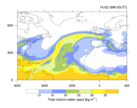
On 13 February, an atmospheric river approached western Europe from the west-north-west, bringing large amounts of moisture towards Switzerland. An atmospheric river is a narrow corridor of air located at relatively low altitude (0-2km) that transports large amounts of moisture from lower latitudes to the mid-latitudes. It is visible in the figure below where high moisture values are found, i.e. approximatively where the total column water vapor is larger than 20 kg/m2 (green and yellow colors).
At the head of the atmospheric river was a warm front, which caused an increase in temperatures as it passed over Switzerland during the night of 13 to 14 February. As the warm and moist air within the atmospheric river was forced to rise over the topography of the Jura mountains, the Prealps and the Alps, intense precipitation was produced in those regions. Since at that time the temperatures were relatively high, a large amount of precipitation fell as rain over the previously accumulated snow (see section Precipitation and temperature). The intense precipitation continued until the afternoon of 15 February, time when the atmospheric river was deviated towards the south and the transport of moist air towards Switzerland decreased.