Service Navigation
Search
What are waterspouts?
The term waterspout refers to an intense columnar or tube-like vortex of small horizontal extent that forms over water. In principle, a waterspout is simply a tornado over water.
Nevertheless, waterspouts over Swiss lakes cannot be compared to the tornadoes that occur in the USA or the Po Valley, for example, as their formation is caused by completely different conditions.
The most damaging tornadoes can be attributed to "supercells" – or to the mesocyclones of supercells – and are described as "type I tornadoes" or "supercell tornadoes".
Overview and explanation: What is a tornado? (german)
When can waterspouts be seen in Switzerland?
In Switzerland, waterspouts typically occur in late summer or early autumn, as this is when there is the greatest overlap between the basic prerequisites: on the one hand, the water in the lakes has warmed up sufficiently towards the end of summer and, on the other, autumn brings a greater likelihood of low-pressure troughs with corresponding cold air.
What a waterspout needs
For a waterspout to form, certain conditions must be present not only at the same time but also in the same place. The basic prerequisites for waterspouts in Switzerland are as follows:
- Passage of a trough/the tail end of a cold front with cold and unstably stratified air
- A lake with warm surface water -> strong vertical temperature gradient
- A humid mass of air
If these three factors are present, then the following are also required for the waterspout to form:
- Localised surface wind convergence -> horizontal wind shear (surface air flowing into an area from different directions)
- Updraft under and in a growing cumulus cloud (ideally with a low cloud base)
- Generally low-wind conditions with only weak vertical wind shear
From invisible air vortex to visible waterspout
Column-like whirlwinds form on the water surface, or rather in the lower layers of air (see diagram below).
In technical terms, a whirlwind of this kind is known as a vortex and has what is known as "vertical vorticity". These vortices are not visible to the naked eye at this stage in the process. If, at the same time, an updraft from a growing cumulus cloud happens to position itself above such a vortex, the vortex is stretched vertically and accelerated in a phenomenon analogous to the "pirouette effect". This is known in technical terms as "vortex stretching" and causes an increase in vertical vorticity.
The described process only works if the flow is relatively weak and is relatively constant with increasing altitude. If the wind is too strong at high levels or changes with altitude, the vortex will be torn apart as soon as it has formed.

Often, the only initial signs of a waterspout are a dark spot on the surface of the water and a "funnel cloud" emerging beneath the cumulus cloud. At this point, however, the vortex is already fully formed – even though it is not yet visible.
Moist air spiralling into the vortex and the pressure drop inside the waterspout cause the funnel cloud to condense from the top down. At this point, a spray ring typically forms over the water. Finally, a fully condensed waterspout develops.
We can imagine this as being like a ballet dancer: if the dancer brings their arms together while doing a pirouette, their rotation gets faster. A similar effect occurs with air in the lower layers: only a small amount of rotation is needed in the wind field over the lake. As the air rises due to warming, it is stretched out and accelerated by the pirouette effect, potentially resulting in the formation of a waterspout.
Strong winds and, in particular, wind shear (a change in wind speed and/or direction with altitude) are unfavourable conditions for waterspout formation. Wind shear can tear the vortex apart, so to speak, before it is even made visible by condensation.
Forecasting waterspouts
Wide-ranging parameters must be considered in order to forecast situations that may lead to waterspouts. One relatively old, tried-and-tested tool is the "waterspout nomogram" developed by W. Szilagyi over 20 years ago. The Szilagyi Waterspout Nomogram is based on extensive observations of vortices over the Great Lakes in the USA. The resulting graph shows which combinations of cloud depth and temperature differences between the water surface and an altitude of approximately 1,500 metres can potentially lead to waterspouts.

Waterspout over Lake Constance, 8 July 2025
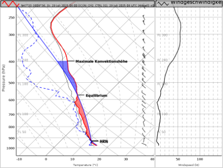
In the lower layers of air, the profile from 8 July 2025 shows a sharp decrease in temperature with altitude, which is ideal for the formation of waterspouts (see radio sounding below). Although the wind is a bit strong, the wind shear is fairly low, which also favours spout formation. Given its size, Lake Constance is a favourable location for waterspouts, and a waterspout was indeed spotted there that morning. On 9 July, slightly warmer air enters at high altitude, while the stratification remains very unstable at lower levels. Moreover, both the wind and the wind shear are slightly weaker than on the previous day. In other words, conditions are also good on the morning of 9 July. It may also help when it comes to observing waterspouts that shower activity decreases slightly due to stabilisation in the intermediate layers. This gives a better view of the developing cumulus clouds and a potential waterspout. Over the course of 9 July, warmer air then also gradually enters the lower layers, reducing the strong temperature contrast between the water and air and bringing the chance of waterspouts down again.