Service Navigation
Search
What are valley and mountain winds?
The mountain and valley wind circulation is a thermally driven local wind system found in mountainous regions. It is a diurnal wind system that mainly occurs during calm, stable high-pressure weather. The driving force behind the mountain and valley wind circulation is solar radiation, which means that valley and mountain winds are thermally driven winds, driven by temperature differences.
How do valley and mountain winds form?
The following factors occur in mountainous areas due to the topography, ultimately ensuring that the air over the mountain slopes warms up faster than in the valley:
- A more favourable angle of incidence: the slopes exposed to the sun and the adjacent air warm up faster.
- The smaller air volume in the mountain valleys (in comparison to the lowlands) that needs to be warmed (known as the ‘volume effect’).
- Lower air density at higher altitudes: correspondingly less energy is needed to heat the air (high-altitude heating surface).
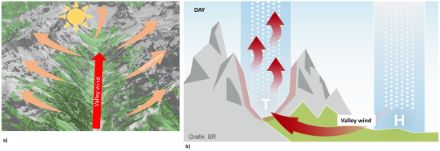
At sunrise, the mountain slopes are the first to be directly exposed to sunlight, and so they warm up quickly (see factor 1 above). Since warm air is lighter than cold air, it rises in warm air bubbles on the sunny slopes. This produces a lower air pressure on the slopes compared to the atmosphere directly above the valley. As air tends to balance out pressure differences, air flows from the valleys towards the mountains, thus creating the upslope wind (see Figure 1a). At the same time, the air above the mountains warms up more quickly on a somewhat larger scale than over the lowlands (see factors 1–3 above), causing the pressure to drop more rapidly and to a greater extent in the mountains. This creates a pressure gradient between the Alps and the lowlands, with higher pressure in the lowlands, and lower pressure over the mountains. As a result, the thermal low that forms draws in air from the lowlands (see Figure 1b). This gives rise to an additional wind that blows up the valley: the valley wind.
In the evening and at night, the conditions are reversed: The air above the mountains cools more rapidly and intensely due to stronger night-time radiation. Colder air has a higher density and is therefore heavier. Thanks to gravity, this colder, heavier air begins to flow downhill near the ground, starting on the slopes. This gives rise to a downslope wind (see Figure 2a).
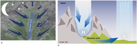
In the higher valleys, too, the air becomes colder than in the lower-lying areas and the Alpine foreland, due to the altitude. This gives rise to a (cold) high-pressure system over the Alps, and a low-pressure system, in relative terms, in the lowlands (see Figure 2b). Due to this pressure difference, the cold air begins to flow down through the valleys into the lowlands. This flow is called a mountain wind. Generally speaking, the downslope winds and mountain winds are much weaker than the upslope and valley winds.
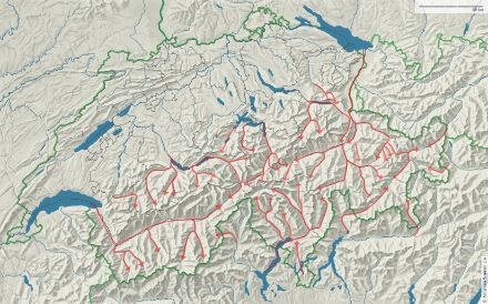
Local valley wind systems in Switzerland
In undisturbed weather conditions with good sunlight, typical valley winds develop in the Alpine valleys (see Figure 3).
When the air from the Alpine foreland is drawn (pumped) into the Alps due to warming in the daytime, this phenomenon is referred to in scientific terms as ‘Alpine pumping’. Valley winds generally blow uphill (see Figure 3).
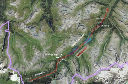
In certain cases, the valley wind system does not stop at the pass but shoots beyond it, blowing downhill for a short distance. Examples include the well-known Malojawind, which blows from Bergell over the Maloja Pass into the Upper Engadine, the valley wind from Prättigau over the Wolfgang Pass near Davos, the valley wind from Haslital over the Grimsel Pass into the Upper Goms (known as the ‘Grimseler’), and the wind from the Flüela Pass into the Lower Engadine.
Reverse valley wind – the Malojawind
On thermally active days, the valley wind in the Upper Engadine does not blow upwards as expected from the Lower Engadine into the Upper Engadine, but flows down the valley from the Maloja Pass. How does the valley wind from Bergell come to extend over the Maloja Pass into the entire Upper Engadine? The major influencing factor is the local topography. Unlike the Engadine, Bergell is a very steeply rising valley. The steep slopes heat up quickly in the morning, creating a thermal low around the Maloja Pass. As a result, a strong, ‘normal’ valley wind often forms in Bergell, which then shoots over the Maloja Pass and continues downhill into the Upper Engadine as the Malojawind. The ‘normal’ valley wind in the Engadine, the Brüscha, stands no chance against the strong ‘Maloja headwind’, which reaches gusts of about 30 to 50 km/h in the afternoon. A westerly to southwesterly upper airflow will intensify the Malojawind, while northerly to northeasterly winds curb or weaken it. The Malojawind is therefore actually an extended valley wind from Bergell that can sometimes reach as far as Samedan or Zuoz.