Service Navigation
Search
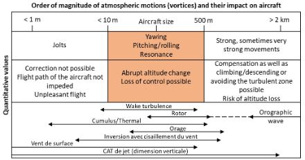
Turbulence: Scale and intensity
In aviation, the term turbulence refers both to air movements that buffet and shake an aircraft, as well as to those that can affect planes in the lowest layers of the atmosphere during take-off and landing, namely, during the most critical phases of a flight. Such air movements take place in an area covering about one metre to one kilometre, and last between one second and several minutes. Very small-scale turbulence creates jolts that cannot be compensated for. These have very little impact on the flight but may be unpleasant for passengers. In the case of much larger air movements (long wavelengths), the entire aircraft can move through these without experiencing shocks or excessive structural stress. The pilot has enough time to climb, descend, or change direction, thereby avoiding any undesirable impacts. When the turbulence is somewhere between these two extremes, rolling and pitching motions occur, increasing the risk of structural damage to the aircraft. Air movements that exert a strong and uneven force on the aircraft’s surface are about the same size as the aircraft itself. Note that in aviation, altitude is usually measured in feet (ft). The strength of turbulent movements and thermal updrafts is expressed in meters per second (m/s).
ICAO Turbulence Scale (International Civil Aviation Organization)
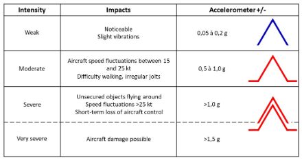
The impacts of turbulence on an aircraft depend on its size, weight and speed. The ICAO Turbulence Scale describes the perceived impacts of the turbulence, the aircraft’s speed fluctuations, and the vertical acceleration it experiences.
The causes of turbulence: General information
Atmospheric turbulence occurs suddenly and often unexpectedly when the wind speed and/or direction change abruptly. This phenomenon is known as wind shear. Wind shear generates vortices that cause turbulence for aircraft. In such situations, vertical wind components (updrafts and downdrafts) play a major role in generating turbulence. Turbulent flows typically arise at high wind speeds, especially when there are significant variations in wind speed or direction over short vertical distances, such as in the upper atmosphere near the jet stream.
Turbulent flows are also caused by obstacles such as mountain ranges (formation of orographic waves in the lee of the Alps during foehn conditions) and even by smaller obstacles such as buildings or hills.
Turbulence can also result from thermal currents: vertical movements due to convective thunderstorms can generate strong to extreme turbulence at high altitudes, within and around thunderstorms, and – in the presence of strong wind gusts – even close to the ground.
In the lower layers of the atmosphere, turbulence can occur during stormy gradient winds (such as Bise or foehn winds), and sometimes also due to sudden fluctuations in air masses (such as with a Joran wind during the passage of a cold front) or in the presence of inversions in winter.
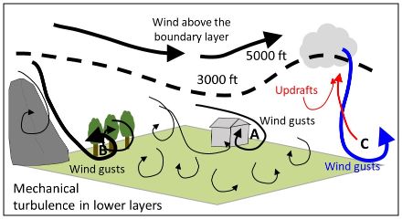
Mechanical turbulence
Mechanical turbulence occurs in the lower atmospheric layers (between the ground and 3,000 to 5,000 ft), where friction due to the roughness of the ground and instabilities caused by daytime ground heating influence the movement of air masses. This layer is known as the “boundary layer” or “friction layer”. In unstable weather conditions, the layer can often extend up to 5,000 ft, whereas in stable weather – especially in winter – it can be less than 300 ft thick due to inversion of the lower atmospheric levels.
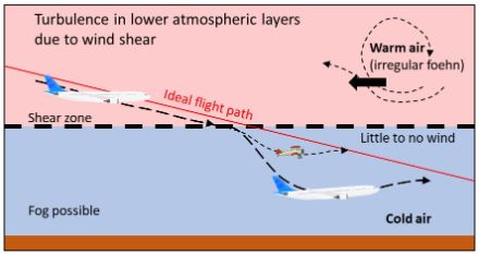
Wind shear when passing through an inversion (entering the boundary layer) causes an aircraft to lose altitude. During foehn conditions, when foehn gusts rebound off an inversion layer, this type of shear can be quite significant, and the inertia of a large aircraft can cause it to lose much more altitude than a smaller one, increasing the risk of landing short of the runway or colliding with an obstacle.
Within the boundary layer especially, wind direction and speed near the surface fluctuate from minute to minute (the direction by ±20° and speed by about 25% compared to the average). Turbulence primarily occurs in strong or stormy winds or due to friction forces at the Earth’s surface, and can be further intensified in the presence of obstacles (e.g. rugged terrain, buildings, forests, etc.). In Switzerland, this type of turbulence can occur during weather conditions with strong Bise, Joran, foehn, or stormy westerly winds.
A Bise or stormy westerly wind with gusts exceeding 60 km/h can give rise to moderate to strong turbulence in the lower atmospheric layers. The funnelling of wind between the Jura mountains and the Pre-Alps, as well as within Alpine valleys, contributes to the intensification of wind gusts, thus increasing the risk of turbulence in the lower layers.
When the Joran blows from the northwest at the southern foot of the Jura, it can cause strong turbulence, particularly at the Geneva and Granges airports, as their runways are oriented from southwest to northeast. In these circumstances, the Joran blows at a right angle to aircraft taking off or landing at these airports.
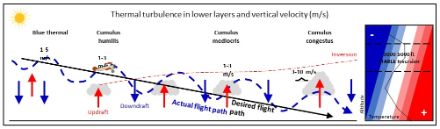
Convective or thermal turbulence
These types of turbulence occur with strong thermal updrafts and downdrafts, and are typically associated with thunderclouds (cumulonimbus, or CB for short). They can affect aircraft in mid-flight as well as during take-off and landing.
Generally speaking, at altitudes below 1,000 ft (~300 m), there is a greater risk of downdrafts than updrafts. During horizontal flight through a thunderstorm, vertical accelerations of 2 to 3 g are possible, and vertical wind speeds can reach extremes of more than 30 m/s. In tropical air masses (with a high tropopause), CB clouds can extend up to around 10 to 13 km (with a maximum of 18 km), while in polar air masses, they generally do not extend higher than about 5 to 7 km. If a thunderstorm extends above 35,000 ft (~11 km), it is considered extremely dangerous.
In isolated thunderstorm cells, convective turbulence tends to be confined to a relatively small area. However, when an aircraft is passing through multicell thunderstorm lines or thunderstorm fronts, the spatial extent of the turbulence is often larger. A gust front can sweep across an entire country like Switzerland. In severe thunderstorms (supercells), the turbulence can be extremely strong.
Turbulence near thunderstorms primarily involves downdrafts. The thunderstorm cell forms a barrier against the prevailing wind, which is then deflected, undulating and swirling. Where this type of turbulence is concerned, strong thunderstorm cells often form (front thunderstorms, supercells) with intense high-altitude winds. In the case of a severe thunderstorm, aircraft should avoid flying within at least 30 to 40 km of the thunderstorm zone.
Turbulence near the anvil cloud of thunderstorms
At higher altitudes, aircraft generally fly above the main cloud zone and can navigate around CBs (cumulonimbus clouds). Techniques to avoid them consist of visual observation and radar imagery. Strong thunderstorm cells that extend above the tropopause interact with strong winds in the stratosphere (in stable atmospheric conditions). This situation can generate gravity waves and turbulence at the upper boundary of the thunderstorm (below the overshooting top), similar to orographic waves in mountainous regions. Pilots must avoid flying near the upper edges of CBs and below the anvil cloud. For every 10 kt of wind measured at the upper edge of the CB, aircraft should fly at least 1,000 ft above the upper edge of the CB. For example, if the wind near the upper edge of the CB is 50 kt, the aircraft should maintain a flight altitude of at least 5,000 ft above the upper edge of the CB.
Downburst, microburst and macroburst
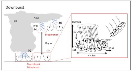
Downbursts are fast, intense downdrafts that can be generated by cumulonimbus clouds. They often occur in hot, dry regions such as Australia and the USA, and can be accompanied by precipitation. The evaporation of the precipitation (a) plays a major role in the formation of microbursts. They can also occur in Europe, especially during long hot and dry periods. Thunderstorms with a higher base, little precipitation but strong wind gusts have been found to occur in such weather conditions.
Downbursts that cover a wide area are known as macrobursts. In such cases, the zone with destructive winds extends horizontally over an area of more than 4 km. Strong macrobursts can cause damage similar to that caused by tornadoes. Winds can last from 5 to 50 minutes and reach peak speeds of up to 60 m/s (~200 km/h).
Microbursts, on the other hand, are small downbursts where the zone with the destructive winds (at least 60 kt, ~110 km/h) does not extend for more than 4 km. In spite of the limited horizontal area, the winds can reach up to 75 m/s (~270 km/h). Generally speaking, a rotor zone (horizontal vortex) forms, which moves outward in concentric circles as soon as the microburst reaches the ground. This main vortex dissolves, creating additional vortices. The phenomenon lasts around 3 to 5 minutes. A microburst can descend from a height of 10,000 ft (~3,000 m) to the ground within about 2 minutes. Microbursts primarily occur when precipitation does not reach the ground (virga).
The evaporation of precipitation (a) creates a zone of denser cold air that flows rapidly towards the ground. Microbursts can occur with CBs whose bases are close to the ground (b), with those that have higher bases (between 5,000 and 15,000 ft), and in areas beneath the anvil (c). In the latter two cases, the evaporation mechanism plays an important role.
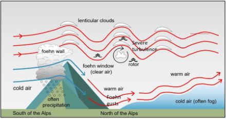
Turbulence due to orographic waves
When a strong wind meets the ridge of a mountain at a right angle, it starts to meander in the lee (the downwind side) of the mountain range. This type of atmospheric wave can extend a very long way up in the troposphere, reaching altitudes of around 10 km and even penetrating the stratosphere. The ascending and descending movements in the lee are called orographic or mountain waves, and they can cause turbulence. Orographic waves gain in intensity as the wind speed increases when passing over the Alps.
These waves become even more pronounced when the wind flow, which is perpendicular to the Alpine range, extends a long way outwards and the average wind speed at summit level is at least 25 kt, or 15 kt where smaller mountains or hills are concerned. Ideally, the wind will strengthen with increasing altitude or at least remain constant.
A stable air layer (an isothermy or inversion) near or above the terrain ensures that the air that initially rose descends again, promoting a wave formation. Such a stable air layer is often found at an altitude of 4 to 5 km (in the mid-troposphere).
In the Alps, orographic waves often develop with southerly or northerly winds (foehn conditions), but they can also occur over the Jura Mountains. Orographic waves can extend up to 200 km beyond the Alpine ridge – towards Germany in southerly wind conditions, and towards Italy in northerly wind conditions.
Clear air turbulence (CAT)
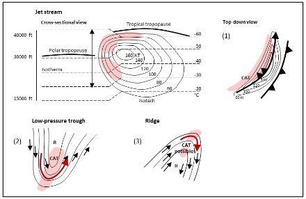
With the exception of turbulence associated with cumulonimbus clouds, all high-altitude turbulence (> 5 to 6 km / > 15,000 ft) is referred to as clear air turbulence (CAT). At high altitudes, vertical wind shears are generally caused by jet streams. The wind speed at the edge of a jet varies markedly over short vertical distances, creating strong shear that leads to CAT.
With increasing altitude, the intensity of high-altitude turbulence gradually decreases. However, turbulence tends to occur more frequently near jet streams and close to the tropopause, as these are zones with strong temperature gradients and significant vertical and horizontal wind shear. CAT at high altitudes is discontinuous and causes sudden jolts (similar to driving over cobblestones). CAT will typically extend horizontally for 80 to 100 km but can sometimes continue for 300 to 500 km. The average vertical extent is around 600 m, although it can be less than 30 m, or, in some cases, exceed 2 km in thickness. The risk of turbulence increases rapidly when vertical wind shear exceeds 5 kt per 1,000 ft of altitude difference. Thermal discontinuities and wind shear at air mass boundaries, such as during a frontal passage or near inversions, can generate CAT. CAT can also occur at lower altitudes, such as due to strong Joran gusts along the southern Jura foothills.
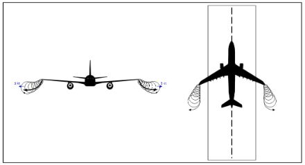
Wake turbulence (non-natural turbulence)
Turbulence is usually caused by natural phenomena, with one exception: wake turbulence is generated by the wingtips of aircraft. The intensity of wake turbulence depends on the aircraft’s weight, speed and wing design, and it is strongest when devices to enhance lift are in use. The strongest wake turbulence is produced by large, heavily loaded, slow-flying cargo planes.
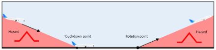
Vortices form near the ground just before landing and immediately after take-off. The danger zone during landing is just before the touchdown point; during take-off, it is just after the rotation point. An aircraft that is following on behind must be especially cautious at these points.
Wake vortices have a diameter of 70 to 150 m and can persist for several minutes (on average 2 minutes) before dissipating and no longer causing turbulence for other aircraft. The weaker the wind, the longer a vortex remains. The risk of wake turbulence can be largely eliminated by maintaining a horizontal separation between two departing or landing aircraft. This is why aircraft must take off at staggered intervals of 1 to 3 minutes.
It is sometimes possible to see a wake vortex: If the air near the ground is humid, water vapour condenses in the zone of strong wind near the vortex centre, making the vortex visible. The tangential speed of such a vortex can be extremely high, but its intensity gradually dies down as the distance from the aircraft grows.
The increase of CAT in the last four decades
A study carried out by the University of Reading found that aircraft today are flying in a more turbulent atmosphere than they were forty years ago. Scientists discovered this in a new study that shows turbulence (CAT) to be increasing in intensity along with climate change.
The study concluded that the annual total duration of severe turbulence over the North Atlantic, one of the world’s busiest air traffic zones, has increased by approximately 55%, from 17.7 hours in 1979 to 27.4 hours in 2020. Moderate turbulence has risen by about 37%, from 70.0 to 96.1 hours, and light turbulence by around 17%, from 466.5 to 546.8 hours. This trend is expected to intensify further with continued global warming.