Service Navigation
Search
MeteoSwiss operates an extensive measuring and forecasting system that paves the way for weather forecasts and warnings around the clock. In the event of an impending storm, MeteoSwiss issues warnings to authorities and the public at an early stage (generally one to two days before the event). By doing so, MeteoSwiss warns of the danger: we warn people of hazards, not risks.
How are warnings published?
On the website (hazard map), MeteoSwiss provides information about impending and current meteorological hazards such as wind, thunderstorms, rain, snow, slippery roads, heat and frost. This information is continually updated.
In the MeteoSwiss app, users can sign up for warnings for any location, type of hazard or warning level in the form of automatic (push) notifications.
The warnings are also published on the Natural Hazards Portal of all federal agencies.
Different levels of thunderstorm warnings
For thunderstorms, there are two danger levels: level 3 and level 4. In spite of state-of-the-art tools and methods, it is not currently possible to forecast heavy thunderstorms with greater precision. Accordingly, there is little sense in establishing further levels of distinction. For warnings of other hazards, a multistep scale is generally used.
A danger level describes how dangerous the impacts may be to the public and to infrastructure. You can find exact descriptions of the danger levels of thunderstorms here: explanations of danger levels for thunderstorms.

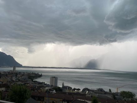
Thunderstorms are difficult weather phenomena to forecast
Thunderstorms are some of the most difficult weather phenomena to forecast. They generally develop within a very short space of time and are highly localised. They can form on the spot and only rain in that location or quickly move on. Many different atmospheric factors also play a role in thunderstorm formation. These include vertical differences in temperature, wind direction and speed, and atmospheric humidity, to name just a few. Other factors can include the extent of snow cover in the Alps, the condition of the vegetation or the nature of the orography.
It is therefore impossible to accurately predict the strength, time or location of thunderstorms several hours in advance. It is not until a thunderstorm has formed that localised thunderstorm warnings are issued at short notice (0 to 1 hours beforehand).
Sequence of a warning situation in the event of thunderstorms
In the event of increased thunderstorm potential (over 40% probability of heavy thunderstorms), a warning outlook is issued for the public and authorities. The latter are additionally informed of the hazard situation in a virtual videoconference. Extensive thunderstorm warnings are issued in the form of advance warnings and warning outlooks for major regions (e.g. the Swiss Plateau, the Jura Arc or the foothills of the Alps), although that doesn’t mean all of the small regions with warnings will actually be affected by thunderstorms. There is nevertheless a greater probability of localised heavy thunderstorms in those regions – but the precise position of the thunderstorms remains uncertain.
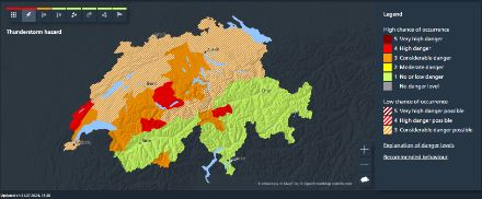
Extensive thunderstorm warning outlooks are sent to the public via the app and website and indicate a possible risk of heavy thunderstorms with a lead time of approximately 6 to 36 hours. These outlooks are shown as hatched areas on the warning map.
Acute warnings – known as “Flash Orages” – are additionally issued for emerging or approaching thunderstorm cells that are expected at a location within the next 30 to 60 minutes and which represent an imminent risk. These Flash Orages are shown in orange (level 3) or red (level 4) on the warning map. The extent and displacement of individual thunderstorm cells is updated on a fully automatic basis every five minutes and is monitored by the meteorologists around the clock within the framework of nowcasting.
Once the danger has passed, the warnings are rescinded.
Analysis and improvement of warnings
Every warning situation of level 3 or higher (not only in the case of thunderstorms) is analysed and evaluated by MeteoSwiss with regard to its accuracy. This process allows us to continually incorporate improvements in our warning procedures, learn from any incorrect estimations and improve our services. An analysis of the quality of storm warnings in 2023 is summarised in this blog post (German).
As well as this analysis and evaluation process, a public survey is also being initiated in relation to warning situations. A pilot phase of these public surveys took place between 2022 and 2025. Feedback from the public therefore also contributes to the continual improvement of warning procedures.