Service Navigation
Search
A regularly occurring weather pattern or singularity is defined as a deviation from the average annual course of meteorological elements that occurs on certain days in the annual calendar with reasonable regularity. As an example of this, the middle of June is reserved for the Schafskälte singularity. Cold snaps that occur at the beginning or end of June do not count as that particular singularity.
Mid-June cold snap
In Switzerland, incoming cold air masses in June are often accompanied by fresh snow falling onto the mountain passes or even somewhat lower. It is not a rare occurrence for Arosa, for instance, at an altitude of 1,850 m.a.s.l., to see fresh snow for one or even a few days in June. This is an illustration of how incoming cold air at higher altitudes can cause a perceptible drop in temperature and usher in winter conditions. These conditions leave their mark on the average June temperature chart.
The return to cooler conditions in mid-June can easily be identified from the daily maximum temperature. The daily minimum temperature, on the other hand, is not an indicator of Schafskälte.
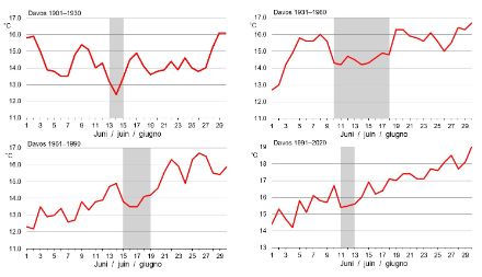
At the Davos weather station during the climate reference period of 1901‒1930, a notable decrease in the average daily maximum temperature can be seen from 13th to 15th June. In the reference period of 1931‒1960, the average daily maximum temperature was significantly lower for the period of 10th to 18th June than it was in the days before and after. In the reference period of 1961‒1990, the Schafskälte occurred slightly later, from 15th to 19th June. In the climate reference period of 1991‒2020, the Schafskälte reverted to its classical dates of 11th to 13th June, albeit in a much milder form.

Occasional absence of the Schafskälte
In an earlier analysis of the period of 1981–2007, there is no evidence of the Schafskälte occurring. On the contrary, the average summer temperature increase in June was frequently interrupted by small temperature dips of similar magnitude throughout the month.
We can conclude from this that chance, i.e. the selection of the analysis period, plays a significant role in the determination of a regularly occurring weather singularity. In other words, something that might feature very prominently in one analysis period may no longer be apparent in the next period.
Where does the name “Schafskälte” come from?
The origin of the term “Schafskälte” is explained in various ways by different authors. Many German-language sources attribute the term to the cold, damp snap in June playing havoc with newly shorn sheep. But in the Swiss Alps, sheep shearing takes place in April, and the sheep have already regrown a sufficiently warm fleece by the time June arrives. Between 15th and 20th June, however, the flocks are moved to the higher grazing in the mountains, and so it is often the case that this move coincides with cold, damp conditions, which gave rise to the term “Schafskälte”, or “sheep’s cold” (information provided by Alexander Dönz in conversation, Chur, June 2009).
References
- Scherhag R., W. Lauer, 1982: Klimatologie. (Climatology.) Das Geographische Seminar. (The Geography Seminar.) Westermann Verlag, Braunschweig.
- Schirmer H., 1987: Meyers kleines Lexikon Meteorologie. (Meyer’s Little Meteorology Dictionary.) Meyers Lexikonverlag. Mannheim, Wien, Zurich.