Service Navigation
Search
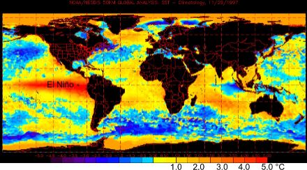
El Niño is primarily characterised by significant warming of the equatorial Pacific Ocean, originating near the South American coastline and propagating westward. Over the longer term, El Niño events can be expected to come around once every few years on average. Since around 1985, the cooler periods between two El Niño events have been known as La Niña.
The severe El Niño events are rare in comparison to the far more frequent weak occurrences of El Niño. Thanks to historical sources, the El Niño events over the last 450 years can easily be ascertained. To our knowledge, there have been 47 strong or very strong El Niño events during this period. “Strong” means an increase in sea surface temperatures of between 3°C and 5°C off the Peruvian coast, while “very strong” means a temperature increase of more than 5°C. On average, strong or very strong El Niño events have recurred every 10 years over the past 450 years, with the interim period varying between 4 and 20 years. Very strong events, or even multi-year periods of very strong El Niño activity, were recorded in 1578, 1685–88, 1728, 1789–93, 1828, 1877/1878, 1891, 1925/26, 1982/83 and 1997/98 (source: Quinn et al. 1987: El Niño occurences over the past four and a half centuries. Journal of Geophysical Research 92 (C 13): 14449-14461).
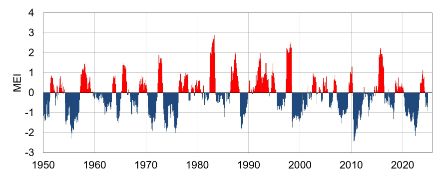
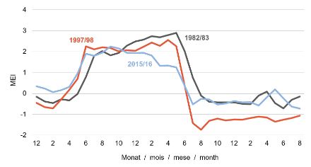
Nowadays, the MEI (multivariate El Niño Southern Oscillation Index) is often used as the measure to quantify the strength of both El Niño and La Niña events. The MEI is calculated from the ground pressure, the east-west and north-south components of the ground wind, the sea surface temperature, the air temperature at sea level and the degree of cloud cover in the equatorial Pacific.
The phenomenon – an overview
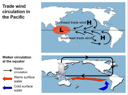
When El Niño is not active – in other words, during the cool La Niña phases – a pronounced area of high pressure (South Pacific anticyclone) gives rise to strong trade winds circulating close to the ground. As they sweep over the sea, the trade winds pick up large volumes of water vapour and transport it over long distances. Over New Guinea and Indonesia, the convergence of the southeast trade wind with the northeast trade wind results in a heavy concentration of moisture.
The constant supply of water vapour ensures its dispersal and its ascent to higher levels of the atmosphere. The warmer the sea surface of the West Pacific, and the more water vapour transported by the trade winds, the greater the concentration of moisture over the Southeast Asian islands. All of this results in a pronounced low-pressure system with intense thunderstorm activity and correspondingly heavy downpours of rain.
The powerful updraft of humid air over Indonesia triggers a flow of air masses from the east along the equator. To compensate for this east-to-west flow close to the ground, the rising air flows back eastwards at high altitudes. It then sinks when it reaches the area of the South American continent, thus creating a closed equatorial circulation, known as the Walker circulation.
Influence on ocean currents
Strong southeast trade winds are the cause of the pronounced east-west ocean current in the equatorial Pacific. These winds push the warm surface water along the equator away from the South American coastline. In Southeast Asia, this results in a surplus of warm water close to the surface of the ocean.
To compensate for the drifting of the warm surface water, cold, deep water from the Antarctic rises to the surface off South America. This then cools the air above the surface of the sea in this area, giving it a correspondingly lower capacity to absorb water vapour. In conjunction with the sinking and, consequently, drying air masses at the edge of the South Pacific anticyclone, this makes for an extremely dry climate, especially on the coasts of Peru and northern Chile.
El Niño circulation
Approximately every two to ten years, the currents in the Pacific undergo substantial change. In such situations, there is often a significant weakening of the usual high-pressure area in the South Pacific. As a result, the southeast trade wind blows only weakly for several months and sometimes collapses altogether. The movement of equatorial water towards Indonesia largely disappears. The warm water that has accumulated in the West Pacific then washes back in the form of a wave, which takes several months to cross the Pacific, usually arriving at the South American coast around Christmas time.
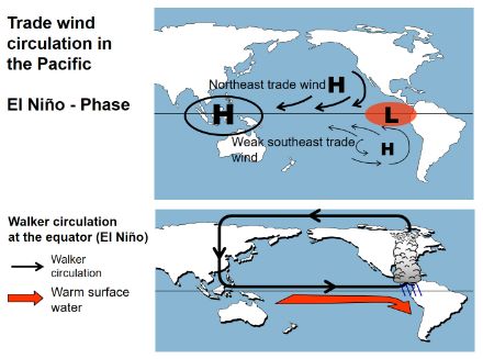
Off the South American coast, the upwelling cold Antarctic water is covered by the receding warm water over a large area. As the warm water disperses in the Southeast Pacific, the South Pacific high-pressure area weakens further, adding to the reduction in the strength of the southeast trade winds. The phenomenon of this change in circulation is called the El Niño Southern Oscillation (ENSO).
The typical course of events
A classic El Niño event lasts for just over a year. The first signs of an impending event often appear from April onwards, with its peak intensity, or maximum, often being reached in the second half of the year. The build-up can sometimes take longer and the maximum is pushed back until the first months of the following year. In fact, the 1986/87 El Niño event peaked between April and August of the following year.
The immediate effects
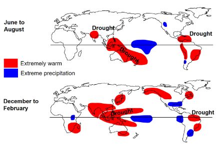
Along with the movement of warm water, the zone of low pressure also shifts from Southeast Asia towards South America. This shift results in a reversal of the Walker circulation in the equatorial Pacific. The warm and very moist air masses that consequently rise off the South American coast trigger heavy precipitation, especially in the coastal areas of Ecuador, Peru and northern Chile, often leading to devastating flooding. The warm sea water is deadly for many marine animals, and their washed-up carcasses can be found strewn along the beaches.
Meanwhile, a pronounced high-pressure system forms over Southeast Asia, and the region is subjected to prolonged drought. An intense El Niño event can destroy a large proportion of the harvest in this region as well as severely depleting the livestock. The severe drought also often leads to widespread forest and bush fires. Although these are caused by humans in many cases, they quickly become out of control due to the severe drought and can rage for months on end, as happened in Indonesia in 1997/98.
Influence on Europe
While there may be some correlations between El Niño and the precipitation regime in Europe, this teleconnection is only very weakly manifested. As a rule, precipitation behaviour in Europe is predominantly controlled by the so-called North Atlantic Oscillation (NAO).
The NAO characterises the pressure fluctuations in the North Atlantic atmosphere. The term oscillation indicates that the North Atlantic atmosphere switches between two states, namely that of a weak south-north pressure gradient to that of a strong south-north pressure gradient. The south-north pressure gradient over the North Atlantic governs the atmospheric flow regime over Europe and consequently also the migration paths of the precipitation-bearing disturbance zones.
When the NAO conditions are neutral, the influence of El Niño becomes more apparent in Europe. According to a report by the German Meteorological Service, more precipitation can be expected in winter in these circumstances, especially along the French Alps and the Jura Mountains and as far as southwest Germany. Large areas of Europe, however, remain unaffected by El Niño.
The name El Niño
El Niño (Spanish for “the boy, the child”, and symbolic of the Christ Child), got its name from Peruvian fishermen, who were often distressed by the unusually pronounced warming of the sea, which often reaches its peak around Christmas time. Fish populations reduce drastically because of the poor nutrient content of the warm water during an El Niño event, which, in former times at least, would have had devastating consequences for the fishing industry. Originally, it was only the warm ocean current that recurred at irregular intervals that was referred to as El Niño. When referring to the phenomenon as a whole, i.e. the reversal of atmospheric and oceanic circulation, the term ENSO was used. Nowadays, however, the terms El Niño and ENSO are often used interchangeably to refer to the phenomenon.