Service Navigation
Search
The winter of 1962/63 was particularly severe, even for that time, when winters were significantly colder in comparison to today. The most obvious manifestations of the extreme winter cold were the freezing of most of the lakes on the Central Plateau, and long-lasting snow cover at low altitudes.
Icy winters
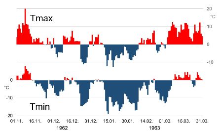
In Zurich, the daily minimum temperature dropped to between -10°C and -14°C for several days towards the end of December 1962. During the same period, even the daily maximum temperature remained very low, at around -10°C.
After a milder start to the new year, the severe and persistent cold weather began. Between 12 January and 7 February 1963, the daily minimum temperature in Zurich was almost always between -12°C and -17°C, while the daily maximum temperature usually remained several degrees below freezing. Ice days were par for the course.
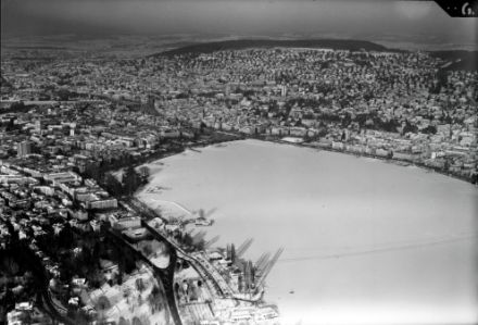
The great lake freeze
The ice sheet on Lake Zurich began to form in the middle of January 1963 at the top end of the lake, in Rapperswil. The last part of the lake basin to freeze over was the area by Zurich, which happened on 24th January 1963. The ice cover was publicly declared to be walkable on 1st February 1963.
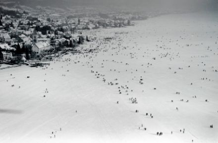
With some brief interruptions, the ice sheet on Lake Zurich basically remained safe to walk on until 7th March 1963, when the daily minimum temperature finally rose above freezing in the Zurich region. A strong southerly wind that blew across the lower half of the lake on 26th and 27th March 1963 ensured that the lake was free of ice within two days.
Smaller lakes frozen first
The smaller lakes on the north side of the Alps were the first to freeze over, with Lake Zurich following later. Lake Biel, for example, was being walked on by thousands of visitors on 27th January 1963. On the other hand, Lake Constance did not fully freeze over until some time in February, although the lower part of Lake Constance, known as the “Untersee”, had frozen over by the second half of January.
Lakes that did not freeze over
However, the low winter temperatures were not sufficient for Lakes Geneva, Neuenburg, Thun, Brienz, Lucerne and Walen to freeze over. There are few, if any, historical accounts of these lakes freezing over. When it comes to the lakes on the south side of the Alps, there are no instances of complete freezing over in recorded history.
Icy polar winds
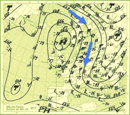
The catalyst for the lakes freezing over was the persistent, icy polar winds against a background of an extensive wave motion in the Atlantic atmosphere. This gave rise, on the American side of the Atlantic, to a strong flux of warm wind from the West Atlantic to Greenland. Over the Arctic, the direction of the flow shifted towards the south. This allowed the influx of cold polar air towards Central Europe and as far as the Mediterranean region. With a further change in direction over the Mediterranean, mild air was then carried towards the East, to Siberia. This substantial shift of air masses over a very large geographical area caused temperatures in Greenland and Siberia to rise to around 5 and 8 degrees higher, respectively, than the norms for that time of year.
The long road to the freeze
The described weather pattern that played out in the winter of 1962/63 was apparently unusual, as can be seen in the 1963 report about the frozen lakes in the annals of the Swiss Federal Office of Meteorology and Climatology. The set of conditions was just right for the lakes to freeze over: severe cold weather over a long period of time.
As the lake water cools after having warmed during the summer, the different layers of water shift around in a process of thermal stratification within a short space of time. A parcel of water that has been cooled at the lake surface now sinks due to its increase in density, settling at the layer of water with the same ambient temperature and, thus, the same density. To take its place, a warmer parcel of water rises to the surface, where it also cools and sinks. As the cooling continues, the same parcel of water rises repeatedly to the surface to be further cooled. This process continues until the entire column of water has reached a temperature of 4˚C. At this temperature, the water has reached its maximum density, and the thermal stratification process comes to an end. Water that is even colder is less dense and therefore remains on the surface. Further cooling to the point of ice formation then takes place only in the uppermost layer of water.
When does Lake Zurich freeze over?
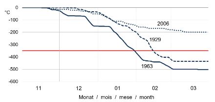
Around 350 so-called “minus-degree days” are required in order for Lake Zurich to freeze over with an ice sheet that is thick enough (12 cm) for people to walk on. To arrive at this figure, analysis of past lake-freezing events calculated the cumulative total of the average temperatures of all days with a sub-zero average temperature from 1st November onwards. Experience tells us that a total of minus 350 can be expected from the end of January onwards in sustained cold conditions.
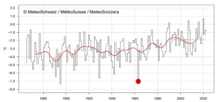
The last icy winter
Switzerland experienced its last severe icy winter in 1962/63. In the measurement period prior to that, similarly cold winters leading to walkable frozen lakes occurred from time to time, with long periods in between. However, the significant increases in winter temperatures over the last few decades have meant that
such occurrences have disappeared from Switzerland’s winter climate.
The lake ice formation in 1963, from the 1963 annals of the Swiss Federal Office of Meteorology and Climatology (Appendix 1, page 13 et seq. in german):