Service Navigation
Search
Weather forecasts with details of weather developments in individual places are currently, and for the foreseeable future, only possible a few days in advance. This is due to the chaotic nature of the atmosphere. The fact that the smallest, unpredictable perturbations can quickly spread means that weather forecasts are restricted to around ten days ahead, at the most. Forecasts for the upcoming season do not make predictions on individual weather occurrences or on the weather conditions of particular days. It is only possible to predict trends regarding average weather conditions. Forecasting in this way removes the chaotic processes from the equation, thus allowing a longer forecasting period. At the same time, however, a whole range of other factors take on a greater significance, such as the soil moisture content and snow cover of the continents, and, above all, the oceanic conditions. When these factors can be taken into consideration, it becomes possible to provide forecasts on weather trends over longer periods of time.
Model simulations on supercomputers
The long-range forecasts produced by MeteoSwiss are based on a coupled ocean-atmosphere-land model. This enables the development of conditions in the oceans and the atmosphere to be simulated with the help of complex comparisons. As in the process for monthly outlooks, all measurements from around the world available at the starting point are fed into the calculation to produce the seasonal outlook. To estimate the uncertainty level of the forecast, numerous such model simulations are carried out. This enables the probability distributions for possible climate conditions to be quantified. The final step is the calibration of the forecasts with past measurements. These comprehensive model simulations are conducted at the European Centre for Medium-Range Weather Forecasts (ECMWF). The ECMWF is jointly run by 34 countries, including Switzerland, to ensure optimum pooling of the member states' individual resources for this highly complex and costly work.
Problematical forecasting for central Europe
Even though significant advances in long-range forecasting have been made in recent years, the benefits of such forecasts are still limited in practice. The models are not equipped to reflect reality in all its complexity, but rely on a number of simplifications. In addition, not all regions of the earth are affected to the same extent by the framework conditions mentioned.
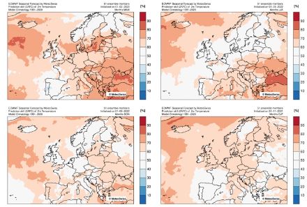
Today's models are fairly inadequate at predicting medium-range weather trends for central Europe, and seasonal forecasts for Switzerland generally do not indicate any clear trends. The maps below illustrate the quality of seasonal forecasts for average temperatures for the four seasons. Red shades represent a level of quality that is better than a simple "best guess" would be on the basis of empirical data from the past 30 years. In Switzerland, seasonal forecasts for autumn and winter offer hardly any added value over climatology, although the success rates are somewhat better for the spring and summer months.

Regions of the world with better-quality forecasts
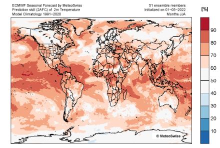
In other regions of the world, the quality of seasonal forecasts is significantly better, as is clearly demonstrated by the same quality mapping of summer forecasts (June to August) on a global scale. This is particularly the case for tropical regions, as well as for regions that are affected by the "El Niño" climate phenomena.
