Service Navigation
Search
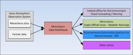
As a Federal Office, MeteoSwiss has a legal mandate to warn the population and authorities about dangerous weather events. To enable it to make more accurate forecasts, it is of the utmost importance to have temporally and spatially dense, high-quality measurement data, as such data represent a central input variable in weather models. MeteoSwiss thus supplements its own monitoring network comprising automatic ground-based stations (SwissMetNet) with measurement data from specialist cantonal departments and other institutions which operate their own monitoring networks. In total, MeteoSwiss works with around 50 domestic and international partners which operate over 2,000 monitoring stations for various fields of application. This allows for gaps in the national monitoring network to be filled and for synergies to be exploited.
Independent certification
The use of measurement data from other monitoring network operators means it is essential that MeteoSwiss, as an ISO-certified Federal Office, ensures the reliability of the measurements and the use of a uniform standard in terms of data quality. To this end, relevant monitoring stations in the SwisMetNet, and those of partners, are subjected to an on-site quality assessment. This is performed by an independent auditor. Only automatic monitoring stations are certified. Among other aspects, the measurement location and instruments, as well as their calibration and maintenance, are checked.
Warnings and forecasts
The partner data flow into MeteoSwiss's data warehouse and are used for various purposes, depending on the station type:
- Warnings
- Weather forecasts
- Verification and assimilation model data
- For combination with precipitation radar data (CombiPrecip)
- Assisting in the homogenization of MeteoSwiss climate data
- Production of grid products and extreme value analysis (e.g. for stations near the borders)
- For feeding into flood forecasting models by the Federal Office for the Environment (BAFU).
- For forwarding to the Joint Information Platform for Natural Hazards (GIN)
Examples
Föhn in the Urn Reuss valley
It is not so easy just to pick one example from the 2,000 stations. We will take a look at the Erstfeld station (INNESF) in the in-Luft measuring network of the central Swiss cantons. It lies around 5 km south of the MeteoSwiss station in Altdorf (ALT). When Föhn weather conditions are building in the south, this is typically observed several hours earlier in Erstfeld than at the MeteoSwiss station in Altdorf, near Lake Urn. This means that MeteoSwiss has a window of time in which it can send a storm warning for Lake Urn.
Verification as to whether the Föhn has actually reached the lake is then made by a different partner station: Isleten, a partner station located right next to Lake Urn, operated by surf-loving staff.
This is just one of the many examples of the benefits of partner data for MeteoSwiss!
WMO: Public-Private-Engagement (Newsletter)
Switzerland’s National Weather Service MeteoSwiss has a long history of using partner data within their own operations. Collaborations with public partners started in early 2000. In those early days, MeteoSwiss did see private weather companies as competitors and conflicts about where and how to measure or about the accuracy of forecasts transpired through the media. The situation changed in 2011 when MeteoSwiss decided to start a cooperation with the private weather company MeteoGroup, the largest operator of a network of private weather stations in Switzerland.