Service Navigation
Search
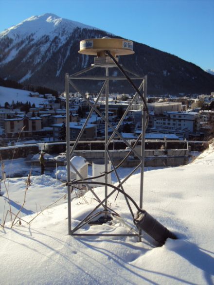
The GPS (global positioning system) is a positioning system which is based on the exchanging of information between the corresponding satellite network and the receivers on the ground. It was developed by the military during the 1970s and is increasingly also being used for civilian applications. For example, the data delivered by the GPS satellites from an altitude of around 20,000 kilometres are also used for land surveying. For this purpose, the Swiss Federal Office of Topography (Swisstopo) operates a permanent network of fixed base stations: The Automated GNSS Network for Switzerland (AGNES) receives the signals from the GPS satellites and processes these for topographic and other applications. The AGNES monitoring network includes 30 surveying devices; nine of these are positioned close to a MeteoSwiss meteorological monitoring station.
GPS and meteorology
These GPS measurements are also used in the area of meteorology. Based on the data recorded, the water vapour content in the troposphere can be estimated, with the level of accuracy being comparable to that of a radiometer or radiosondes. This important meteorological parameter is not only linked to precipitation, but also impacts atmospheric dynamics through its latent heat content.
Estimating the water vapour content
The GPS signal which is transmitted the distance between the satellite and the receiver is subject to deflection (refraction) due to the pressure, temperature and humidity of the atmosphere. This deflection is reflected in the signal's higher transmission time, on the basis of which the effect of humidity can be isolated. This allows for the total water vapour content as well as the water vapour content at the various altitudes (vertical profile) of the tropospheric column above the GPS location to be estimated.
Use of GPS data at MeteoSwiss
Swisstopo processes the GPS data to provide MeteoSwiss with an estimate of the total water vapour content. MeteoSwiss also measures the vertical profile of the water vapour content using both radiosounding and radiometers. The values measured using these instruments are compared with the figures provided by Swisstopo in order to check their accuracy.
The development of methods with which ever more precise vertical profiles can be generated on the basis of GPS data is currently the focus of a cooperation between MeteoSwiss and ETH Zurich (Swiss Federal Institute of Technology). MeteoSwiss also participates in the European E-GVAPII programme, which has the objective of keeping the European water vapour monitoring network operational as well as expanding the network through the use of GPS data.