Service Navigation
Search
An atmospheric river can be described as a long and narrow corridor of air in which intense moisture transport takes place. This transport occurs in the lower atmosphere, i.e. between 0 and 2km altitude and over a large area, since atmospheric rivers are typically longer than 2000km. They play an important role in the transport of moisture from the tropical regions towards the mid-latitudes and are in some cases responsible for large precipitation amounts.
In the case of May 2015, an atmospheric river transported moisture from the western tropical Atlantic Ocean across the ocean towards Switzerland between 30 April and 6 May. The atmospheric river was associated with several small cyclonic systems, which allowed the transport of moisture during several days and over such a long distance.
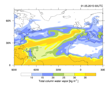
The atmospheric river is visible in the figure below over the Atlantic Ocean approximatively where the total column water vapor is larger than 20 kg/m2 (green, yellow and orange colors). It is less distinguishable over land, because the moisture is depleted out of the atmosphere through precipitation, resulting in lower values of total column water vapor than over the ocean (blue colors).
In Switzerland, the precipitation did not fall continuously between 30 April and 4 May but occurred in the affected region in three successive phases. The first phase started during the night of 30 April to 1 May, when the atmospheric river approached Switzerland from the west. The ascent of the moist air above the Swiss topography first caused precipitation over the Jura and at the foot of the Jura mountains, and then extended over the whole northern side of the Alps as the moist air travelled across Switzerland. The precipitation lasted until the morning of 2 May.
During most of the day of 2 May, the transport of moisture towards Switzerland was reduced, allowing a break in precipitation. In the afternoon, a new inflow of moist air from the atmospheric river arrived from the west-south-west, producing the second and third precipitation phases recorded in the affected region on 2 and 3 May. At the same time, a warm front passed over Switzerland, bringing warmer air from the south-west and causing a rise in temperatures.
On 4 May, the flow changed direction and switched from a westerly to a southerly flow, causing a situation of foehn and a further increase in temperatures on the northern side of the Alps, as well as a decrease in precipitation in that area.