Service Navigation
Search
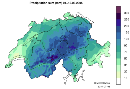
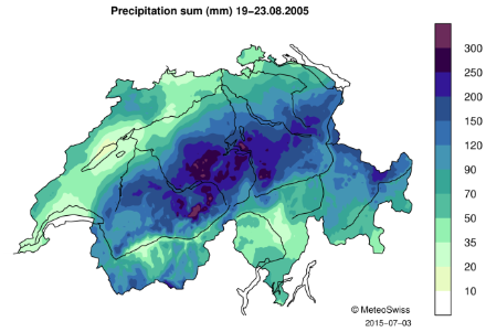
Precipitation sums
The first half of the month of August 2005 was already very wet. Between 1 and 18 August, large regions in the Prealps and in the northern part of the Alps recorded precipitation equivalent to more than 75% of the mean August precipitation in these regions.
During the event of 19-23 August 2005, precipitation fell mostly in the regions which had already received a lot of precipitation during the first half of the month (Prealps and northern part of the Alps), as well as in the north-eastern Grisons. The highest 5-day precipitation amounts were measured on the central and eastern Alpine north slope (e.g. Gersau, 297.6 mm; Weesen, 287.9 mm; Flühli, 256.7 mm; Stöckalp, 250.1 mm). The precipitation fallen in 5 days during this event represents up to 1.5 times more precipitation than what is usually measured in August at those stations (norm 1981-2010).
When considering the whole month of August 2005, the rainfall amounts were particularly high. Many stations in Switzerland recorded precipitation amounts that correspond to one and a half to two and a half times more precipitation than the amount recorded on average in August.
Daily precipitation
The precipitation event of 19-23 August 2005 consisted of two successive phases of precipitation. During the first phase (19-20 August), the precipitation, caused by the passage of a cold front over Switzerland, was not very intense (maximum of 34.1 mm and 56.3 mm measured respectively on 19 and 20 August). Taken alone, these precipitation amounts would not have had high impacts in Switzerland.
However, this first phase was followed by a second phase of intense precipitation. Because of the transport of warm and moist air from the Mediterranean and Adriatic Seas towards Switzerland from the north-east and the interaction of this air mass with the Alpine range, heavy precipitation was triggered on the northern side of the Alps and large amounts of water fell over Switzerland, especially on 21 and 22 August.
At first, the precipitation affected mostly the Plateau and the Prealps (21 August), where high rainfall amounts were measured. On 22 August, the zone of intense precipitation shifted eastwards, causing intense precipitation to fall on the northern flank of the Alps and the north-east of the Grisons. That day, the highest daily precipitation sum during the whole event was also measured (241.8 mm at station Weesen in the canton of St. Gallen).
On 23 August, rainfall amounts over Switzerland decreased considerably and only some regions in eastern Switzerland recorded precipitation.
Maximum daily precipitation measured during the event of 19-23 August 2005. Source: MeteoSwiss
| Date | Station | Maximum daily precipitation |
|---|---|---|
| 19.08.2005 | Gersau (SZ) | 34.1 |
| 20.08.2005 | Flühli (LU) | 56.3 |
| 21.08.2005 | Entlebuch (LU) | 131.4 |
| 22.08.2005 | Weesen (SG) | 241.8 |
| 23.08.2005 | Starkenbach (SG) | 31.3 |
Daily mean temperature
During this event the 0°C isotherm was located above 3000m, resulting in the precipitation falling in a liquid form over most of Switzerland.
Downloads
RhiresD is the spatial analysis of daily precipitation in Switzerland. The daily precipitation on day D corresponds to the rainfall and snowfall water equivalent accumulated from 06:00 UTC of day D to 06:00 UTC of day D+1. For more information about this data set, see the documentation given below.
TabsD is the spatial analysis of the daily mean air temperature 2m above ground level and is representative of the average from midnight to midnight UTC. For more information about this data, see the documentation given below.