Service Navigation
Search
Focus
- In Switzerland, an increase in the intensity and frequency of heavy rainfall was observed during the 20th Century. The intensity of the heaviest ten-minute precipitation in summer has increased by around 20 percent since the 1980s.
- Heavy precipitation will become even more intense in all seasons in the future, especially with global warming of 3 degrees Celsius, compared to pre-industrial times. The increase is particularly noticeable in hourly heavy precipitation events, such as those that occur during thunderstorms.
- An extreme precipitation event that occurs on average every 50 years in the reference period 1991-2020 could occur about twice as often with global warming of 3 degrees Celsius.
- A warmer atmosphere can absorb more water vapour, which can rain out during heavy precipitation. If the temperature rises by 1 degree Celsius, the air can store 6-7 percent more water. Observations, theory and climate model simulations show that intensification of heavy precipitation follows these patterns.
Heavy precipitation causes very large amounts of rain to fall in a short period of time. This is of enormous importance in Switzerland as it poses a considerable risk to the environment, society and the economy. It can trigger floods, debris flows and landslides, which can cause major damage to infrastructure and disrupt agriculture and the economy, and in serious cases it can even lead to fatalities. An intensification of heavy rainfall can already be observed today. This increasing burden makes heavy rainfall a key issue for flood protection, spatial planning and standardisation, as well as for adaptation to climate change in general.
Further information on the effects of climate change and measures in various sectors can be found on the website of the National Centre for Climate Services (NCCS).
Observed increase in heavy precipitation in Switzerland
In Switzerland, an increase in the intensity and frequency of heavy rainfall was observed during the 20th Century. This increase was particularly noticeable in summer. The intensity of short-duration events (e.g., lasting around ten minutes) increased more than longer-duration events. The intensity of the heaviest ten-minute precipitation in summer has increased by around 20 percent since the 1980s, whilst the heaviest three-hour precipitation has increased by around 10 percent.
On the north side of the Alps and in the Alps themselves, heavy precipitation is predominantly a summer phenomenon, whereas on the south side of the Alps, several consecutive days of heavy precipitation often occur in autumn as well. Long-term observations since 1901 show that heavy one-day precipitation events have become significantly more intense and more frequent throughout Switzerland.
The rise in air temperature largely explains the increasing intensity of heavy rainfall. For every degree of warming, the air can absorb 6 to 7 percent more water. Accordingly, heavy rainfall can become more intense as temperatures continue to rise.
Extreme events today, versus in the future
As temperatures continue to rise, the intensity and frequency of heavy precipitation events will increase across all seasons. With global warming of 3 degrees Celsius compared to pre-industrial times – in a so-called 3-degree world (GWL3.0) – the strongest one-day precipitation events of the year are expected to increase by around 9 percent compared to the reference period 1991–2020. The shorter the duration of precipitation events, the greater the increase in intensity. Development of heavy precipitation events varies greatly in terms of time and space and can deviate from the long-term trend over longer periods. Overall, however, the models show a consistent increase.
A single-day precipitation event that occurs once every 50 years in the reference period 1991–2020 will occur twice as often in a 3-degree world. In summer, the increasing intensity of individual precipitation events is likely to be more frequently associated with thunderstorms and hailstorms.
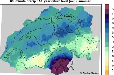
The 50-year return value of single-day precipitation describes the amount of precipitation that falls within a single day and is exceeded once every 50 years on average over a long period. It serves as a measure of extreme heavy precipitation events, which occur rarely but often cause serious damage. Return values are often used as a key figure for the design of infrastructure, such as flood protection systems or for the drainage of roads, buildings and settlements.

In summer, more intense precipitation does not rule out a simultaneous decrease in total precipitation: although it rains less frequently, individual events produce larger amounts of rain in a short period of time. Heavy precipitation can cause significant damage, for example through flooding or mudslides. In addition, the rise in the snow line in winter increases the proportion of liquid precipitation and further increases the amount of water entering rivers.
In addition to the intensity of precipitation, its frequency and annual pattern are also changing.