Service Navigation
Search
Weather type classifications provide a simplified albeit incomplete description of the atmospheric state. Classifications used throughout Europe differ widely in the classification method, the geographical domain they are tailored to, the meteorological parameters they are based on, and the number of types. This hampers a systematic comparison and evaluation. Moreover, weather types are traditionally derived manually and depend on the personal expertise of those who carry out the classification. This may introduce spurious temporal inhomogeneities in the classifications and calls into question their use in climate analyses.
The COST Action 733 is a coordinated European effort to overcome these limitations. The objectives of MeteoSwiss within COST 733 are twofold. First, automatic classifications are to be identified that represent climate variability in the Alps particularly well. This will provide the scientific basis for the planned replacement of the currently operational manual classifications by an automatic method. Second, it is examined if and how weather-types can be exploited as supplementary information for spatial precipitation analysis. This aims at improving real-time analyses from measurements at the coarse network of automatic rain gauges.
Data and methods
The COST Action 733 “Harmonisation and Applications of Weather Type Classifications for European Regions” is a coordinated effort to develop, compare, and apply numerical methods for the objective classification of weather situations in European regions.
Currently, participants from 21 European countries collaborate within COST 733. Swiss participants are the University of Berne (Institute of Geography) and MeteoSwiss.
The objectives of MeteoSwiss within COST 733 are:
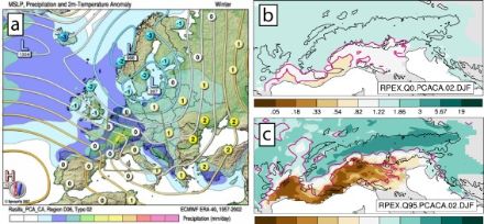
- To identify automatic classification methods[1] that could complement or substitute manual schemes currently in use at MeteoSwiss[2,3]. To this end, various schemes are compared with respect to their ability to describe surface climate variations. In these analyses, particular emphasis is put on the distribution of precipitation in the Alps ([4], Figure 1).
- To examine if and how weather type information could be exploited as supplementary real-time information for spatial precipitation analysis. These studies seek to improve real-time analyses based solely on the sparse network of automatic rain-gauges (Figure 2).
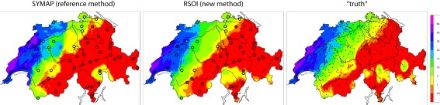
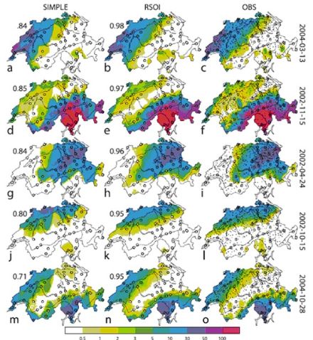
Reduced space optimal interpolation of daily rain gauge precipitation in Switzerland
Application of the reduced space optimal interpolation
The coarse spacing of automatic rain gauges complicates near-real-time spatial analyses of precipitation. We test the possibility of improving such analyses by considering, in addition to the in situ measurements, the spatial covariance structure inferred from past observations with a denser network. To this end, a statistical reconstruction technique, reduced space optimal interpolation (RSOI), is applied over Switzerland, a region of complex topography. RSOI consists of two main parts. First, principal component analysis (PCA) is applied to obtain a reduced space representation of gridded high-resolution precipitation fields available for a multiyear calibration period in the past. Second, sparse real-time rain gauge observations are used to estimate the principal component scores and to reconstruct the precipitation field. In this way, climatological information at higher resolution than the near-real-time measurements is incorporated into the spatial analysis. PCA is found to efficiently reduce the dimensionality of the calibration fields, and RSOI is successful despite the difficulties associated with the statistical distribution of daily precipitation (skewness, dry days). Examples and a systematic evaluation show substantial added value over a simple interpolation technique that uses near-real-time observations only (figure 1). The benefit is particularly strong for larger-scale precipitation and prominent topographic effects. Small-scale precipitation features are reconstructed at a skill comparable to that of the simple technique. Stratifying the reconstruction method by the types of weather type classifications yields little added skill. Apart from application in near real time, RSOI may also be valuable for enhancing instrumental precipitation analyses for the historic past when direct observations were sparse.
How to quantify the resolution of surface climate by circulation types
An example for Alpine precipitation
A novel approach is presented for the evaluation of circulation type classifications (CTCs) in terms of their capability to predict surface climate variations. The approach is analogous to that for probabilistic meteorological forecasts and is based on the Brier skill score. This score is shown to take a particularly simple form in the context of CTCs and to quantify the resolution of a climate variable by the classifications. The sampling uncertainty of the skill can be estimated by means of nonparametric bootstrap resampling.
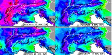
The evaluation approach is applied for a systematic intercomparison of 71 CTCs (objective and manual, from COST Action 733) with respect to their ability to resolve daily precipitation in the Alpine region. For essentially all CTCs, the Brier skill score is found to be higher for weak and moderate compared to intense precipitation, for winter compared to summer, and over the north and west of the Alps compared to the south and east (fig.1). Moreover, CTCs with a higher number of types exhibit better skill than CTCs with few types. Among CTCs with comparable type number, the best automatic classifications are found to outperform the best manual classifications. It is not possible to single out one «best» classification for Alpine precipitation, but there is a small group showing particularly high skill.
This study was carried out in the framework of ESSEM COST Action 733 and also supported by EU-FP6 Project ENSEMBLES and the ECA&D Project.
[1] Philipp, A, et al., 2010: Cost733cat - A database of weather and circulation type classifications, Physics and Chemistry of the Earth, 35, 360-373, doi:10.1016/j.pce.2009.12.010
[2] Schüepp, M, 1968: Kalender der Wetter- und Witterungslagen von 1955 bis 1967. MeteoSchweiz Veröffentlichungen, 11, 44pp.
[3] Perret, R, 1987: Une classification des situations météorologiques à l'usage de la prévision. MeteoSchweiz Veröffentlichungen, 46, 127pp.
[4] Schiemann, R. and Frei, C., 2010: How to quantify the resolution of surface climate by circulation types: An example for Alpine precipitation. Physics and Chemistry of the Earth, Vol.35, 403-410.
[5] Rasilla Álvarez, D F, 2003: Aplicación de un método de clasificación sinóptica a la Península Ibérica. Investigaciones Geográficas, 30, 27-45, Instituto Universitario de Geografía, Universidad de Alicante, in Spanish.
[6] Frei, C, and Schär, C, 1998: A precipitation climatology of the Alps from high-resolution rain-gauge observations. Int. J. Climatol., 18, 873-900.
[7] Schiemann, R, and Frei, C, 2010: How to quantify the resolution of surface climate by circulation types: An example for Alpine precipitation, Physics and Chemistry of the Earth, 35, 403-410, doi:10.1016/j.pce.2009.09.005
[8] Schiemann, R, Liniger, M A, and Frei, C, 2010: Reduced space optimal interpolation of daily rain gauge precipitation in Switzerland, J. Geophys. Res., 115, D14109, doi:10.1029/2009JD013047